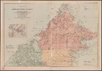
Covers Brunei, Sabah, and northern Sarawak., Includes inset location map., Land available for sale or sold indicated., Library copy accompanied by manuscript notes., and Relief shown by hachures and spot heights. Soundings in fathoms.
Publisher:
Published by Edward Stanford for the British North Borneo Company,
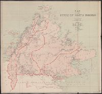
Also shows telegraph lines and cables, and railways., In lower left margin: London atlas series., Relief shown by hachures and spot heights., and Yale's copy signed in ink below scale: Matt[?] Brewer, July 1894.
Publisher:
Edward Stanford, 26 & 27 Cockspur St., Charing Cross, S.W.,
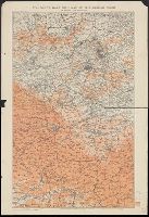
Map to illustrate the Treaty of San Stefano and Stanford's map of south-eastern Europe and Armenia illustrating the Treaty of San Stefano, the new limits of Bulgaria, Servia, Roumania, Montenegro, etc., etc., and the acquisitions of Russia
Description:
Inset: Map of Armenia to illustrate Article XIX of the Treaty of San Stefano. and Map of southeastern Europe showing existing boundaries and boundaries proposed in the Treaty of San Stefano. Relief shown by hachures.
Publisher:
Edward Stanford,
Subject (Geographic):
Balkan Peninsula--Maps
Subject (Topic):
Eastern question (Balkan)--Maps and Treaty of San Stefano--(1878)--Maps
Edward Stanford Ltd. Stanford's war maps ; no. 17. and Stanford's war maps ; no. 17
Description:
"New edition, enlarged" printed in red above upper right margin. and Shows railways, roads, canals, and approximate position of Battle Front as of June 1916 and June 1917.
Publisher:
Edward Stanford Ltd.,
Subject (Geographic):
Belgium--Maps and France--Maps
Subject (Topic):
World War, 1914-1918--Campaigns--Western Front--Maps