Bar scales given in English miles, 60 in a degree, Irish miles, 50 in a degree, and Dutch miles, 15 in a degree., Drawn from the survey made by Sr. Wm. Petty ; divided into its provinces, counties, and barronies, shewing also its bishopricks, borroughs, highwaies ... ; improved with many additions not extent in any other map., Includes inset map The sea coast of England, Scotland, and Ireland, Holland & part of France., No. 8 of 69 maps bound together in composite atlas., and Scale [ca. 1:540 000].
Publisher:
Sold by Rob. Morden at the Atlas in Corn-hil and by Christ. Brown at the Globe and Compasses in St. Pauls Churchyard
Ferro meridian., No. 38 of 43 maps bound together in composite atlas., Relief shown by hachures., Scale [1:1,750,000]., and Shows rivers and settlements.
Subject (Geographic):
Egypt --Maps --Early works to 1800 and Nile River --Maps --Early works to 1800
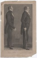
Print reproduces a pair of full-length portraits of Hyrum and Joseph Smith drawn by Maudsley from originals painted by David Rogers; an image of the Temple at Nauvoo, in reduced scale, is shown between the figures of the two men; the two men are dressed formally, hold walking sticks in their right hands, and face right in profile.
Alternative Title:
Temple of Nauvoo
Description:
Another state of this image, colored and with slightly different letters, includes the imprint, London: Moses Martin, 1847., Below image: Temple of Nauvoo., and Title from caption.
Publisher:
[Moses Martin?]
Subject (Name):
Le Blond & Co., engraver, Maudsley, Sutcliffe, 1809-1881, artist, Nauvoo Temple (Nauvoo, Ill. : 1841-1850)--Pictorial works, Smith, Hyrum, 1800-1844--Pictorial works, and Smith, Joseph, Jr., 1805-1844--Pictorial works
British & Spanish territories according to the treaty of 1784
Description:
For a description of the second and third states see Stevens and Tree, Comparative Cartography, Map Collectors' Circle (1967)., Includes historical notes and a color key., Includes text., No. 40 of 43 maps bound together in composite atlas., Prime meridian: London., Relief shown pictorially., Scale [ca. 1:6,750,000]., and Shows numerous boundary changes.
Publisher:
Willm. Faden
Subject (Geographic):
United States --Boundaries --Maps --Early works to 1800 and United States --Maps --Early works to 1800
Allan, A., Capt Beatson, Alexander, 1759-1833 Harmar, Thomas Rennell, James, 1742-1830, creator
Published / Created:
1792 February 21
Call Number:
1982 Folio 10
Image Count:
1
Description:
Compiled from the original maps, drawn by Capt. A. Beatson and Capt. A. Allan ; with some particulars added in explanation by J. Rennell ; plan work by I. Walker ; writing by T. Harmar., Map with relief shown pictorially., No. 33 of 43 maps bound together in composite atlas., and Scale [ca. 1:750,000].
Publisher:
J. Rennell
Subject (Geographic):
India, South --History, Military --Maps --Early works to 1800
Principal islands in America belonging to the English empire viz Jamaica, Barbados, Antegoa, St. Christophers & Bermudos
Description:
[Antigua and Bermuda Islands] -- A general map of the Cariby Islands -- [Saint Kitts] -- [Barbados] -- The explanation of the marks on the island of Iamaica., Bar scale given in miles., No. 62 of 69 maps bound together in composite atlas., Relief shown pictorially., and Scales differ.
Publisher:
Sold by Phillip Lea at the Atlas and Hercules in Cheapside