
- None3
You Searched For
1 - 3 of 3
Search Results

1. England [art original]
- Creator:
- Hughes, J., active 1872, artist
- Published / Created:
- [30 March 1872]
- Call Number:
- Drawings H893 no. 1 Box D128
- Image Count:
- 1
- Resource Type:
- still image
- Abstract:
- A comic map of Great Britain: an old woman is shown in profile, facing to the left, and seated on the back of a dolphin-like monster. At the top her cap is Scotland; her neck is labeled R. Tees (River Tees) and along her back is "Humber" and "The Wash" The mouth of the creature is labeled "Thames". The other points on the map are: Isle of Wight and Bristol Channel, Cardogan Bay, and Anglesea (a bird perched on the woman's out-stretched hand).
- Alternative Title:
- Britannia
- Description:
- Title supplied by artist above design., Added title supplied by cataloger, based on the Gillray print of which this is a copy., Signed and dated by the artist in lower margin., and Drawn after James Gillray's print "Britannia", published 25 June 1791. Cf. No. 8045 in the Catalogue of prints and drawings in the British Museum. Division I, political and personal satires, v. 6.
- Subject (Geographic):
- England
- Found in:
- Lewis Walpole Library > England [art original]
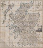
2. Scotland : drawn and engrav'd from a series of angles and astronomical observations
- Creator:
- Ainslie, John (Surveyor)
- Published / Created:
- [1800]
- Call Number:
- Folio 15 800Ai
- Image Count:
- 1
- Resource Type:
- cartographic image
- Alternative Title:
- Scotland drawn and engraved from a series of angles and astronomical observations
- Description:
- Title from cartouche., Engraved throughout., Relief shown by contour lines and pictures., Scale of miles 69 1/2 to a degree., Another imprint: "Published according to Act of Parliament Jan. 1st. 1789 by John Ainslie ... and William Faden ..." at bottom of sheet., Inset maps: "Shetland Islands laid down upon a less scale than the map ... "; "A Map of the Orkney Islands ...", Distance tables and lists of heights of hills and roads from Edinburgh to London., Edinburgh meridian, with note of degrees from Greenwich., Title cartouche shows men fishing and herding cattle, with sheep goats and foliage., Six compass roses., This issue not in Chubb, T. Printed maps in the atlases of Great Britain and Ireland., and Scotland.
- Publisher:
- Printed and sold by the proprietor Thomas Brown, North Bridge Street, Edinburgh and Publish'd according to Act of Parliament with improvements till 1800 by Thomas Brown ... Edinburgh and William Faden ... London
- Subject (Geographic):
- Scotland, Orkney (Scotland), Shetland (Scotland), Scotland., Orkney., and Shetland.
- Subject (Topic):
- Description and travel and Travel
- Found in:
- Lewis Walpole Library > Scotland : drawn and engrav'd from a series of angles and astronomical observations

3. Voornaamste gebouwen vande stadt Romen t'Amsterdam
- Creator:
- Ram, Johannes de, 1648-1693, printmaker
- Published / Created:
- [approximately 1690]
- Call Number:
- 724 690R
- Image Count:
- 59
- Resource Type:
- still image
- Abstract:
- Views of Rome (including the Vatican City), London, Amsterdam, and Tangier
- Description:
- All engraved. and Bound in full contemporary calf, spine gilt, red morocco label. For further information, consult library staff.
- Publisher:
- publisher not identified
- Subject (Geographic):
- London (England), Rome (Italy), Amsterdam (Netherlands), and Vatican City
- Found in:
- Lewis Walpole Library > Voornaamste gebouwen vande stadt Romen t'Amsterdam