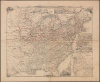
Insets: Railroad & canal routes from Albany to Buffalo -- Map showing the rail roads between the cities of New York, Boston & Albany and the Hudson R. from N. York to Albany -- Rail road route from New York to Philadelphia -- Rail road route from Philadel
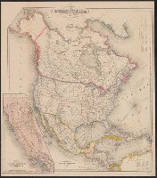
"Engraved by J.M. Atwood. N.Y.", "Showing the proposed routes to the Pacific Ocean.", Relief shown by hachures., and Shows canals, steamboat lines, finished and unfinished railroads.
Publisher:
J. Disturnell,
Subject (Geographic):
Canada--Maps and United States--Maps
Subject (Name):
Disturnell, John, 1801-1877
Subject (Topic):
Railroads--Canada--Maps and Railroads--United States--Maps
Carl I. Wheat map collection. CU-BANC and New map of the United States and Canada
Description:
Covers southern Canada, including New Brunswick, Prince Edward Island, and Nova Scotia., Inset: Map of Oregon, California, New Mexico & c. [continuation of main map, 1:10,600,000], and Main map extends west to cover most of Montana, Wyoming, Colorado, most of N
Publisher:
Published by J. Disturnell,
Subject (Geographic):
Canada--Maps and United States--Maps
Subject (Name):
Atwood, John M., b. ca. 1818 and Disturnell, John, 1801-1877
Includes tables of distances for overland routes and sea routes., Inset: Map of the gold region California. Scale [ca. 1:4,752,000]., Prime meridian: Washington, D.C., and Relief shown by hachures.
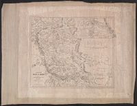
Map of the route between Vera Cruz, Alvarado & Puebla.
Description:
"Entered according to act of Congress in the year 1847 by John Disturnell in the clerks of, Includes "Profile of the route between Mexico and Vera Cruz" and "Map of the route between Vera Cruz, Alvarado & Puebla.", and Relief shown by hachures and spot heights.
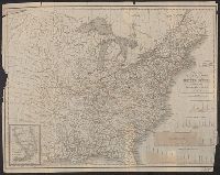
"Entered according to Act of Congress in the year 1839, by H.S. Tanner of the state of Pennsylvania.", Canals are shown in red and yellow. Railway lines shown in blue; proposed lines in green., Copy with canals, railroads colored, and borders colored., and Inclu
Publisher:
T.R. Tanner & J. Disturnell,
Subject (Geographic):
United States--Maps.
Subject (Name):
Disturnell, John, 1801-1877 and Knight, J. (Jonathan), 1787-1858
Subject (Topic):
Canals--United States--Maps. and Railroads--United States--Maps.
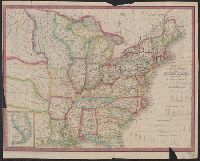
"Entered according to Act of Congress in the year 1839, by H.S. Tanner of the state of Pennsylvania.", Canals are shown in red and yellow. Railway lines shown in blue; proposed lines in green., Copy with canals and railroads colored., and Includes 4 canal cross
Publisher:
T.R. Tanner & J. Disturnell,
Subject (Geographic):
United States--Maps.
Subject (Name):
Disturnell, John, 1801-1877 and Knight, J. (Jonathan), 1787-1858
Subject (Topic):
Canals--United States--Maps. and Railroads--United States--Maps