- Creator:
- Robert Sayer and John Bennett (Firm)
- Published / Created:
- 1776
- Call Number:
- 755 1776
- Container / Volume:
- BRBL_00430
- Image Count:
- 1
- Resource Type:
- Maps, Atlases & Globes
- Alternative Title:
- Middle British colonies.
- Description:
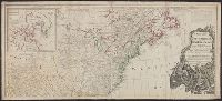
- "The seat of the war in the middle British colonies, containing Virginia, Maryland, the Delaware counties, &ca.", From the author's The American military pocket atlas. [1776], Hand colored., Inset: A sketch of the upper parts of Canada., and Relief shown pictoria
- Publisher:
- Printed for R. Sayer & J. Bennett, map, chart & printsellers,
- Subject (Geographic):
- Northeastern States--Maps--Early works to 1800
- Subject (Name):
- Pownall, Thomas, 1722-1805
- Subject (Topic):
- British--America--Maps--Early works to 1800
- Found in:
- Beinecke Rare Book and Manuscript Library > A general map of the middle British colonies, in America [cartographic material] : Containing Virginia, Maryland, the Delaware counties, Pennsylvania and New Jersey. With the addition of New York, and the greatest part of New England, as also of the borde
You Searched For
1 - 10 of 10
Search Results
- Creator:
- Delarochette, L. (Louis), 1731-1802
- Published / Created:
- 1765
- Call Number:
- 71 1765
- Container / Volume:
- BRBL_00364
- Image Count:
- 1
- Resource Type:
- Maps, Atlases & Globes
- Description:
- "Longit. west from Ferro I.", "Printed for John Bowles at the Black Horse in Cornhill & Carington Bowles in St. Pauls Church yard, London.", and Differs from other copy in coloration. Only boundaries are colored, emphasis is on showing the internal boundaries o
- Publisher:
- Printed for John Bowles,
- Subject (Geographic):
- North America--Maps--Early works to 1800
- Subject (Name):
- Bowles, Carington, 1724-1793, Bowles, John, 1701-1779, and Palairet, Jean, 1697-1774
- Subject (Topic):
- British--America--Maps--Early works to 1800
- Found in:
- Beinecke Rare Book and Manuscript Library > A map of North America / by J. Palairet, with considerable alterations & improvements from d'Anville, Mitchell & Bellin, by L. Delarochette.
3.
- Creator:
- Mitchell, John, 1711-1768
- Published / Created:
- [1773]
- Call Number:
- 71 1773
- Container / Volume:
- BRBL_00365
- Image Count:
- 4
- Resource Type:
- Maps, Atlases & Globes
- Description:
- "Longitude west from London.", First impression of 3d ed., Includes text and inset "A new map of Hudson's Bay and Labrador from the late surveys of those coasts.", and Relief shown pictorially.
- Publisher:
- Printed for Jefferys and Faden, geographers to the King,
- Subject (Geographic):
- North America--Maps--Early works to 1800
- Subject (Name):
- Jefferys and Faden, London and Kitchin, Thomas, d. 1784
- Subject (Topic):
- British--America--Maps--Early works to 1800
- Found in:
- Beinecke Rare Book and Manuscript Library > A map of the British and French dominions in North America : with the roads, distances, limits, and extent of the settlements, humbly inscribed to the Right Honourable the Earl of Halifax, and the other Right Honourable the Lords Commissioners for Trade &
4.
- Creator:
- Mitchell, John, 1711-1768
- Published / Created:
- [1775?]
- Call Number:
- 71 1755A
- Container / Volume:
- BRBL_00363
- Image Count:
- 8
- Resource Type:
- Maps, Atlases & Globes
- Description:
- Fourth ed., In bottom margin: Publish'd by the author Febry 13th 1755 according to act of Parliament., Includes text and inset "A new map of Hudson's Bay and Labrador from the late surveys of those coasts.", Relief shown pictorially., and Yale's copy stamped on b
- Publisher:
- Printed for Jefferys and Faden, geographers to the King,
- Subject (Geographic):
- North America--Maps--Early works to 1800
- Subject (Name):
- Jefferys and Faden, London and Kitchin, Thomas, d. 1784
- Subject (Topic):
- British--America--Maps--Early works to 1800
- Found in:
- Beinecke Rare Book and Manuscript Library > A map of the British colonies in North America : with the roads, distances, limits, and extent of the settlements, humbly inscribed to the Right Honourable the Earl of Halifax, and the other Right Honourable the Lords Commissioners for Trade & Plantations
5.
- Creator:
- Pownall, Thomas, 1722-1805
- Published / Created:
- 1777
- Call Number:
- 71 1777B
- Container / Volume:
- BRBL_00365
- Image Count:
- 1
- Resource Type:
- Maps, Atlases & Globes
- Description:
- Includes historical notes, insets of "A particular map of Baffin and Hudson's Bay" and "The passage by land to California," and articles 4-7, 9, 12, 13, and 20 of the "definitive treaty.", Prime meridian: London and Ferro., Relief shown pictorially., and Stamped
- Publisher:
- Printed for Robt. Sayer and Jno. Bennett,
- Subject (Geographic):
- North America--Maps--Early works to 1800
- Subject (Name):
- Robert Sayer and John Bennett (Firm)
- Subject (Topic):
- British--America--Maps--Early works to 1800
- Found in:
- Beinecke Rare Book and Manuscript Library > A new and correct map of North America, with the West India Islands : divided according to the last treaty of peace, concluded at Paris. 10th. Feby. 1763, wherein are particularly distinguished, the several provinces and colonies, which compose the Britis
- Creator:
- Pownall, Thomas, 1722-1805
- Published / Created:
- [1783?]
- Call Number:
- 71 1783B
- Container / Volume:
- BRBL_00366
- Image Count:
- 2
- Resource Type:
- Maps, Atlases & Globes
- Description:
- Date in printer statement, in lower right margin: 15th July 1779., Includes notes and insets of "A particular map of Baffin and Hudson's Bay" and "The passage by land to California ....", Prime meridian: London and Ferro., and Relief shown pictorially.
- Publisher:
- Printed for Robt. Sayer and Jno. Bennett,
- Subject (Geographic):
- North America--Maps--Early works to 1800
- Subject (Name):
- Robert Sayer and John Bennett (Firm)
- Subject (Topic):
- British--America--Maps--Early works to 1800
- Found in:
- Beinecke Rare Book and Manuscript Library > A new and correct map of North America, with the West India Islands : divided according to the preliminary articles of peace, concluded at Versailles, 20 Jan. 1783, wherein are particularly distinguished, the United States & the several provinces and colo
- Creator:
- Pownall, Thomas, 1722-1805
- Published / Created:
- 1794 May 12
- Call Number:
- 71 1794
- Container / Volume:
- BRBL_00367
- Image Count:
- 2
- Resource Type:
- Maps, Atlases & Globes
- Description:
- Insets: A particular map of Baffin and Hudson's Bay -- The passage by land to California., Prime meridians: London and Ferro., Relief shown pictorially., and Yale's copy 1 joined on 2 sheets, 54 x 121 cm. and 54 x 120 cm.; coloring differs from copy 2; and stamp
- Publisher:
- Published by Laurie & Whittle, No. 53 Fleet Street,
- Subject (Geographic):
- North America--Maps--Early works to 1800
- Subject (Name):
- Robert Laurie and James Whittle
- Subject (Topic):
- British--America--Maps--Early works to 1800
- Found in:
- Beinecke Rare Book and Manuscript Library > A new map of North America with the West India Islands : divided according to the preliminary articles of peace, signed at Versailles, 20 Jan. 1783, wherein are particularly distinguished the United States, and the several provinces, governments &ca which
- Creator:
- Pownall, Thomas, 1722-1805
- Published / Created:
- 1794 May 12
- Call Number:
- 71 1794
- Container / Volume:
- BRBL_00367
- Image Count:
- 1
- Resource Type:
- Maps, Atlases & Globes
- Description:
- Insets: A particular map of Baffin and Hudson's Bay -- The passage by land to California., Prime meridians: London and Ferro., Relief shown pictorially., and Yale's copy 1 joined on 2 sheets, 54 x 121 cm. and 54 x 120 cm.; coloring differs from copy 2; and stamp
- Publisher:
- Published by Laurie & Whittle, No. 53 Fleet Street,
- Subject (Geographic):
- North America--Maps--Early works to 1800
- Subject (Name):
- Robert Laurie and James Whittle
- Subject (Topic):
- British--America--Maps--Early works to 1800
- Found in:
- Beinecke Rare Book and Manuscript Library > A new map of North America with the West India Islands : divided according to the preliminary articles of peace, signed at Versailles, 20 Jan. 1783, wherein are particularly distinguished the United States, and the several provinces, governments &ca which
- Creator:
- Bowen, Emanuel, -1767
- Published / Created:
- 2d. July 1772.
- Call Number:
- 71 1763
- Container / Volume:
- BRBL_00364
- Image Count:
- 4
- Resource Type:
- Maps, Atlases & Globes
- Alternative Title:
- Particular map of Baffin and Hudson's Bay and Passage by land to California discover'd by Father Eusebius Francis Kino ...
- Description:
- "Longit. w. from Ferro.", Hand colored., Includes historical notes, notes on territorial claims, and insets of "A particular map of Baffin and Hudson's Bay" and "The passage by land to California.", and Relief shown pictorially.
- Publisher:
- Printed for Robert Sayer, no 53 Fleet Street ...,
- Subject (Geographic):
- North America--Maps--Early works to 1800
- Subject (Name):
- Gibson, J. (John), active 1750-1792 and Sayer, Robert, 1725-1794
- Subject (Topic):
- British--America--Maps--Early works to 1800
- Found in:
- Beinecke Rare Book and Manuscript Library > An accurate map of North America [cartographic material] : Describing and distinguishing the British and Spanish dominions on this great continent; according to the definitive treaty concluded at Paris 10th Feby. 1763. Also all the West India Islands belo
- Creator:
- Overton, Henry, 1675 or 6-1751
- Published / Created:
- [1755?]
- Call Number:
- 755 1756F
- Container / Volume:
- BRBL_00428
- Image Count:
- 1
- Resource Type:
- Maps, Atlases & Globes
- Description:
- 2nd state. Distinguishing feature of 2nd state: "Title changed slightly to read 'An accurate map of the British Colonies...'" (McCorkle 111)., 755 1756F: Verso: Stamped "Oct 23 1959"., Printed text in left and right margins., and Published separately as broadsid
- Publisher:
- printed for and sold by H. Overton,
- Subject (Geographic):
- North America--Maps--Early works to 1800 and United States--History--French and Indian War, 1755-1763--Maps--Early works to 1800
- Subject (Topic):
- British--America--Maps--Early works to 1800
- Found in:
- Beinecke Rare Book and Manuscript Library > An accurate map of the British colonies in North America bordering on the river Ohio.