Search
You Searched For
Search Results
- Creator:
- Frere, Thomas, engraver
- Published / Created:
- [ca. 1860?]
- Call Number:
- Shirley +285
- Collection Title:
- Funny leaves for the younger branches / by Baron Krakemsides of Burstenoudelafen
- Image Count:
- 2
- Resource Type:
- Books, Journals & Pamphlets
- Found in:
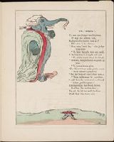
- Beinecke Rare Book and Manuscript Library > "The Verdict"
- Creator:
- Frere, Thomas, engraver
- Call Number:
- Shirley +285
- Collection Title:
- Funny leaves for the younger branches / by Baron Krakemsides of Burstenoudelafen
- Image Count:
- 2
- Resource Type:
- Books, Journals & Pamphlets
- Found in:
- Beinecke Rare Book and Manuscript Library > "They try him"
- Creator:
- Berger, D. (Daniel), 1744-1825
Chodowiecki, Daniel, 1726-1801
- Call Number:
- Zm Sp79
- Collection Title:
- Allgemeines historisches Taschenbuch, oder, Abriss der merkwurdigsten neuen Welt-Begebenheiten
- Image Count:
- 1
- Found in:
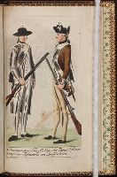
- Beinecke Rare Book and Manuscript Library > 1. Americanischer Scharffschuetz oder Faeger, (rifleman)
- Published / Created:
- 1808-14
- Call Number:
- Sy13 U2 +808W
- Collection Title:
- American ornithology; or, The natural history of the birds of the United States : illustrated with
- Image Count:
- 1
- Found in:
- Beinecke Rare Book and Manuscript Library > 1. Corcus Cristatus, Blue jay
- Published / Created:
- 1850
- Call Number:
- 1976 Folio 96
- Collection Title:
- A new universal atlas containing maps of the various empires, kingdoms, states and republics of the
- Image Count:
- 1
- Resource Type:
- Maps, Atlases & Globes
- Found in:
- Beinecke Rare Book and Manuscript Library > 10. Map of Connecticut
- Creator:
- Bodmer, Karl, 1809-1893
- Published / Created:
- 1841
- Call Number:
- ZZc20 839wig
- Collection Title:
- Illustrations to Maximilian Prince of Wied's Travels in the interior of North America
- Image Count:
- 1
- Found in:
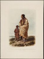
- Beinecke Rare Book and Manuscript Library > A Dacota Woman. Tab. 9
- Published / Created:
- 1776
- Call Number:
- Cb23 27
- Collection Title:
- The American military pocket atlas : being an approved collection of correct maps, both general and
- Image Count:
- 1
- Found in:
- Beinecke Rare Book and Manuscript Library > A General map of the northern British colonies in America. which comprehends the province of Quebec, the government of Newfoundland, Nova-Scotia, New-England and New-York. From the maps published by the Admiralty and Board of Trade regulated by the astronomic and trigonometric observations of M. von Holland and corrected from Governor Pownall's late map 1776.
- Creator:
- Romans, B
- Published / Created:
- 1776
- Call Number:
- Cb23 27
- Collection Title:
- The American military pocket atlas : being an approved collection of correct maps, both general and
- Image Count:
- 1
- Found in:
- Beinecke Rare Book and Manuscript Library > A General map of the southern British colonies, in America, comprehending North and South Carolina, Georgia, east and west Florida, with the neighbouring Indian countries. From the modern surveys of engineer de Brahm, Capt. Collet, Mouzon & others; and from the large hydrographical survey of the coasts of east and west Florida
- Creator:
- Brasier, William
- Published / Created:
- 1776
- Call Number:
- Cb23 27
- Collection Title:
- The American military pocket atlas : being an approved collection of correct maps, both general and
- Image Count:
- 1
- Found in:
- Beinecke Rare Book and Manuscript Library > A Survey of Lake Champlain, including Lake George, Crown Point and St. John. Surveyed by order of His Excellency Major General Sr. Jeffery Amherst, knight of the most honble. Order of the Bath, Commander in Chief of His Majesty's forces in North America (now Lord Amherst) by William Brassier, draughtsman, 1762
- Published / Created:
- 1776
- Call Number:
- Cb23 27
- Collection Title:
- The American military pocket atlas : being an approved collection of correct maps, both general and
- Image Count:
- 1
- Found in:
- Beinecke Rare Book and Manuscript Library > A general map of the middle British colonies in America. Containing Virginia, Maryland, the Delaware counties, Pennsylvania and New Jersey. With the addition of New York, and of the greatest part of New England, as also of the bordering parts of the province of Quebec, improved from several surveys made after the late war, and corrected from Governor Pownall's late map 1776.