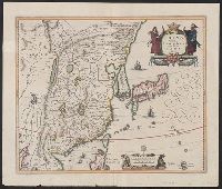
"Cum privil.", "I. Bormeester, eccu.", Bar scales given in "Gemene Duÿtsche Mÿlen 15 in een Graedt" and "Uren gaens de 4 maken 3 Mÿlen"., BEIN 1973 Folio 18: Backed with paper. Ms. no. "41" in upper-right corner. Sheet measures 53.6 x 62.7 cm. No. 40 of 87 maps bound together., Inset: De resterende Eÿlanden van Hollant alhier bÿgevoecht., North oriented to the upper-right., Prime meridian: Ferro., Relief shown pictorially., and Title in Latin; place names in Dutch.
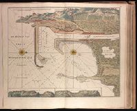
"Aende nieuwe-brug met previlegie"., Backed with paper. Ms. no. "10" in upper right-hand corner. Sheet measures 53.5 x 62.5 cm. No. 9 of 87 maps bound together., Bar scale given in "Duytsche Myl"., Relief shown pictorially; depths shown by soundings., Watermark., and With north oriented towards upper left.
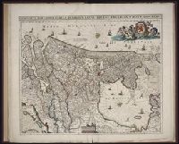
Publisher:
By Gerard van Keulen,
Subject (Geographic):
Wismar (Germany)--Maps--Early works to 1800.
Subject (Topic):
Nautical charts--Germany--Wismar Bay--Early works to 1800.
"Aen de nieuwen brugh met previlegi"., Backed with paper. Ms. no. "58" in upper right-hand corner. Sheet measures 53.7 x 62.3 cm. No. 53 of 87 maps bound together., Bar scale given in "Duytsche Myl"., Relief shown pictorially; depths shown by soundings., With north oriented towards the right., and With two inset maps at bottom: "Caap Cette N W ten N4" and "Caap Cette N W ten W 3."
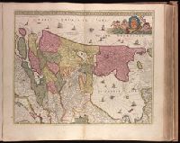
Publisher:
By Gerard van Keulen,
Subject (Geographic):
Sète (France)--Maps--Early works to 1800.
Subject (Topic):
Nautical charts--France--Sète--Early works to 1800.
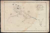
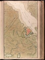
Backed with paper. Ms. no. "13" in upper right-hand corner. Sheet measures 53.6 x 35.5 cm. No. 13 of 87 maps bound together., Bar scale given in "Duytsche Mylen"., Relief shown pictorially; depths shown by soundings., Shows troop positions during siege of Stralsund during the Northern War, ca. 1715., and Title derived from place locations on map.
Publisher:
By Gerard van Keulen ...,
Subject (Geographic):
Rügen Island (Germany)--Maps--Early works to 1800. and Stralsund (Germany)--Maps--Early works to 1800.
Subject (Name):
Anse, Luggert van, fl. 1690-1716, engraver.
Subject (Topic):
Nautical charts--Baltic Sea--Early works to 1800. and Northern War, 1700-1721--Maps.
From Augustin Calmet's Byvoegzel tot het algemeen groot historisch, oordeelkundig, chronologisch, geografisch, en letterlyk naam- en woord-boek (1731). and Watermark.
Publisher:
[Samuel Luchtmans],
Subject (Geographic):
Antioch (Turkey)--Pictorial works--Early works to 1800.
Subject (Name):
Calmet, Augustin, 1672-1757. Byvoegzel tot het algemeen groot historisch, oordeelkundig, chronologisch, geografisch, en letterlyk naam- en woord-boek. and Luchtmans, Samuel, 1685-1757