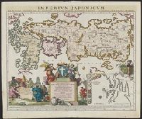
A variant of second state of the latinized atlas version of "Le Japon divisé en soissante et six provinces ...," with date "1715" below imprint. See: Lutz Walter, Japan: a cartographic vision, entry OAG 73 and Includes inset of Nagasaki and its surroundings.
Subject (Geographic):
Japan--Maps--Early works to 1800
Subject (Name):
Ottens, Joachim, 1663-1719, publisher and Ruyter, Balthasar, engraver
Uytenbogaart, J. W. H. (Johannes Wilhelmus Huybert) Wit, Frederik de., creator
Published / Created:
[1680?]
Call Number:
1973 Folio 10
Image Count:
1
Resource Type:
Maps, Atlases & Globes
Description:
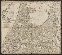
Appears in the Wit's Atlas from 1680., Dedication: Amplissimo Doctissimoque Viro Domino Do. Joanni Uytenbogaert Jcto. nomine Illustrium et praepotent. DD. ordinum Hollandiae et Westvrisiae Aerary Publici Amstelodamensis Tribuno., Includes color illustrated views of Messina, Catania, and Trapano, and ancillary maps of Milazzo and Palermo., No. 21 of 69 maps bound together in composite atlas., Oriented with north toward the upper left., Relief shown pictorially., Scale indeterminable., and Urbibus praecipuis exornatum et novissime editum per F. de Wit.
Publisher:
Gedruckt tot Amsterdam by Frederik de Wit inde Kalverstraet by den Dam inde Witte Paskaert
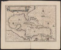
Insulae Americanae in Oceano Septentrionali cum terris adjacentibus and Insvlae Americanae in Oceano Septentrionali cum terris adiacentibus
Description:
Appears in various Dutch eds. of Jansson's Nieuwen atlas., Includes scales in milliaria germanica and mill, and Shows southeast coast of North America from Virginia to north coast of South America to east of Trinidad, west coast of Central America, West Indies.
Publisher:
Apud Ioannem Ianssonium,
Subject (Geographic):
Caribbean Area--Maps--Early works to 1800, Mexico, Gulf of--Maps--Early works to 1800, and West Indies--Maps--Early works to 1800
Subject (Name):
Jansson, Jan, 1588-1664. Atlas novus. Dutch
Subject (Topic):
Coasts--North America--Maps--Early works to 1800 and Coasts--South America--Maps--Early works to 1800
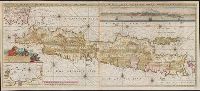
Also shows p, Includes text, col. view of Jakarta, inset of Jakarta, and some cities are marked with gilt., Library copy joined to form 1 sheet., Pars occidentalis --, Prime meridian: Ferro., and Title and notes in Latin. Place-names and scale statements in Dutch.
Publisher:
by Gerard van Keulen aan de Nieuwe brug met previlegie,
Subject (Geographic):
Jakarta (Indonesia)--Maps--Early works to 1800 and Java (Indonesia)--Maps--Early works to 1800
East West Greenland, Scoresby 1822, 1:2,800,000., Insets: Straat of Waaigat 1:100,000., Mauritius of Jan Mayen Eil. 1611, 1:533,000., and Siberia to Cape Chelyuskin.