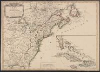
Delarochette, L. (Louis), 1731-1802, cartographer.
Call Number:
23 1794A
Image Count:
1
Resource Type:
Maps, Atlases & Globes
Alternative Title:
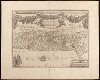
Chart of the northwest coast of America and the northeast coast of Asia, explored in the years 1778 and 1779
Description:
Below title: Advertisement, the interesting discoveries made by British and American ships since the first publication of this chart in 1784, together with the hydrographical materials lately procured from St. Petersburg and other places , have enabled Mr. De la Rochette to lay down the numerous improvements which appear in the present edition, Charing Cross, January 1st, 1794, W. Faden., Includes notes., Relief shown pictorially. Depths shown by soundings., and With watermark dated 1801.
Subject (Geographic):
Bering Strait Region--Discovery and exploration--Maps--Early works to 1800., North America--Discovery and exploration--Maps--Early works to 1800., Pacific Coast (North America)--Discovery and exploration--Maps--Early works to 1800., and Russian Far East (Russia)--Discovery and exploration--Maps--Early works to 1800.
Subject (Name):
Cook, James,--1728-1779., Faden, William, 1749-1836, publisher., Palmer, W. (William), 1739-1812, engraver., and Roberts, Henry, 1757-1796.
Subject (Topic):
Discoveries in geography. and Discoveries in geography--Maps--Early works to 1800.
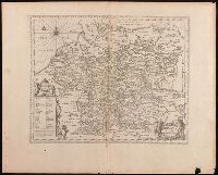
Keere, Pieter van den, 1571-approximately 1646, cartographer.
Published / Created:
[between 1652 and 1684]
Call Number:
BrSides Double Folio 2019 103
Image Count:
1
Resource Type:
Maps, Atlases & Globes
Description:
Appears in Jansson's historical atlas editions from 1652-1684., Manuscript number in upper left corner: 13., and Relief shown pictorially.
Publisher:
Apud Joannem Janssonium,
Subject (Geographic):
Benelux countries--Historical geography--Maps--Early works to 1800., Benelux countries--Maps--Early works to 1800., Europe, Central--Historical geography--Maps--Early works to 1800., and Europe, Central--Maps--Early works to 1
Subject (Name):
Jansson, Jan, 1588-1664, publisher.
Subject (Topic):
Ethnology--Europe--Maps--Early works to 1800. and Germanic peoples--Maps--Early works to 1800.
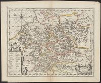
Appears in Jansson's historical atlas editions from 1652-1684., Hand colored., and Relief shown pictorially.
Publisher:
Apud Joannem Janssonium,
Subject (Geographic):
Benelux countries--Historical geography--Maps--Early works to 1800., Benelux countries--Maps--Early works to 1800., Europe, Central--Historical geography--Maps--Early works to 1800., Europe, Central--Maps--Early works to 1800., Europe, Eastern--Historical geography--Maps--Early works to 1800., Europe, Eastern--Maps--Early works to 1800., Germany--Historical geography--Maps--Early works to 1800., and Germany--Maps--Early works to 1800.
Subject (Name):
Jansson, Jan, 1588-1664
Subject (Topic):
Ethnology--Europe--Maps--Early works to 1800. and Germanic peoples--Maps--Early works to 1800.
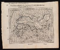
I haue heere added for the readers profit and delight this map of Iapan, published by I. Hondivs, I have heere added for the readers profit and delight this map of Iapan, published by I. Hondius, and Japan I.
Description:
Relief shown pictorially., Removed from Samuel Purchas's Purchas his Pilgrimage (1625)., and Text in English on verso with signature 3M3 at foot of map.
Publisher:
[Printed by William Stansby for Henrie Fetherstone],
Subject (Geographic):
Japan--Maps--Early works to 1800.
Subject (Name):
Featherstone, Henry, -1647, bookseller., Purchas, Samuel, 1577?-1626. Purchas his Pilgrimage. 1625., and Stansby, William, active 1597-1638, printer.
Imperatorskai︠a︡ akademīi︠a︡ nauk (Russia), cartographer, publisher.
Call Number:
23 1773
Image Count:
1
Resource Type:
Maps, Atlases & Globes
Description:
Includes title in embellished cartouche., Map of northwestern North America and the Russian Far East including the Bering Strait region showing the exploration routes of Bering, Chirikov, and other Russian explorers., and Relief shown pictorially.
Subject (Geographic):
Bering Strait Region--Discovery and exploration--Russian--Maps--Early works to 1800., North America--Discovery and exploration--Russian--Maps--Early works to 1800., and Russian Far East (Russia)--Discovery and exploration--Russian--Maps--Early works to 1800.
Subject (Topic):
Discoveries in geography--Maps--Early works to 1800. and Discovery and exploration, Russian.
Adrichem, Christiaan van, 1533-1585, cartographer.
Published / Created:
[between 1652 and 1684]
Call Number:
BrSides Double Folio 2019 97
Image Count:
1
Resource Type:
Maps, Atlases & Globes
Description:
Coordinates not present on map and are approximated., Manuscript number in upper left corner: 42., Oriented with north to the lower left., Relief shown pictorially., and Verso blank.
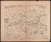
Tribus Ruben, et Gad et partes orientales tribuum Benjamin, Ephraim, et dimidiae Manasse intra Jordanem
Description:
Appears in Jansson's historical atlas editions from 1652-1684 and in his Accuratissima orbis antiqui delineatio. From 1653 on, this work is known under the name of Hornius, who wrote the text and compiled all the maps for the atlases--(Koeman-Krogt. 1:601-1:607)., Coordinates not present on map and are approximated., Includes many biblical scenes and notes., Manuscript number in upper left corner: 47. No. 1 of 6 maps housed together., Map indexed with grid lines and alphabet letters J-O at top of map under title., Map of the Hebrew tribes of Reuben and Gad, with the eastern parts of the tribes of Benjamin, Ephraim, and half of Manasseh beyond the Jordan River., Oriented with north to the left., Relief shown pictorially., and The first map drawn of a series of six sheets that form an enlarged adaptation of Andrichom's "Sitius Terrae Promissionis". This map is the sheet positioned at top, center.
Publisher:
[Jan Jansson],
Subject (Geographic):
Middle East--Palestine. and Palestine--History--To 70 A.D.--Maps--Early works to 1800.
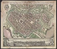
Breslau die uhralte u[nd] hochberühmte Haupt Statt des Herzogth. Schlesien auch vortrefflicher aufenthalt der Musen u[nd] florisanter Handels Plaz an dem Oder Strom and Breslau die uhralte und hochberühmte Haupt Statt des Herzogth. Schlesien auch vortrefflicher aufenthalt der Musen und florisanter Handels Plaz an dem Oder Strom
Description:
"Cum gratia et privil. S.R.I. Vicariat[us] in partib[us] Rheni, Svevice, et Juris Franconici.", Ancillary view: Breslaw. Not drawn to scale., Buildings shown pictorially., Includes index, text, and illustrations., Latin and German., and Sheet measures 56 x 40 cm.
Subject (Geographic):
Wrocław (Poland)--Aerial views--Early works to 1800. and Wrocław (Poland)--Maps--Early works to 1800.
Subject (Name):
Karpinski, Louis Charles,--1878-1956--Ownership., Karpinski-von Wieser Map Collection., and Wieser, Franz,--Ritter von,--1848-1923--Ownership.