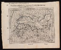
I haue heere added for the readers profit and delight this map of Iapan, published by I. Hondivs, I have heere added for the readers profit and delight this map of Iapan, published by I. Hondius, and Japan I.
Description:
Relief shown pictorially., Removed from Samuel Purchas's Purchas his Pilgrimage (1625)., and Text in English on verso with signature 3M3 at foot of map.
Publisher:
[Printed by William Stansby for Henrie Fetherstone],
Subject (Geographic):
Japan--Maps--Early works to 1800.
Subject (Name):
Featherstone, Henry, -1647, bookseller., Purchas, Samuel, 1577?-1626. Purchas his Pilgrimage. 1625., and Stansby, William, active 1597-1638, printer.
"Entered according to acts of Congress in the year 1863 by J. H. Colton in the Clerks Office of the District Court of the United States for the Southern District of New York.", Insets: Southern part of Florida ; Proposed railroad routes to the Pacific Ocean., Prime meridian: Washington, D.C., Prime meridian: Washington., Printed by Lang & Cooper., and Relief shown by hachures.
Publisher:
J.H. Colton, 172 William Street,
Subject (Geographic):
Confederate States of America--History--Civil War, 1861-1865--Maps. and Southern States--Maps.
Subject (Name):
Colton, J. H. (Joseph Hutchins), 1800-1893., Lang & Cooper, printer., and Rusling, James Fowler, 1834-1918.
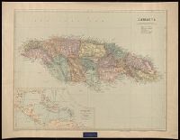
"2827.", "BCM/Stanfordmaps.", "Printed in Great Britain.", Includes ancillary map, "The West Indies and Central America.", Label: International Map Company ... New York, N.Y. Backed with linen., and Relief shown by shading and spot heights.
Publisher:
Edward Stanford Ltd., 12, 13, & 14 Long Acre W.C.,
Subject (Geographic):
Jamaica--Maps.
Subject (Name):
Edward Stanford Ltd. and International Map Company Bookplate.
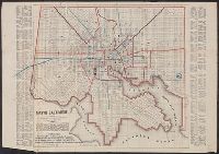
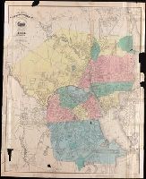
Above neat line at bottom left: Wm. Sides surveyor Balto., Identifies street names, major buildings, wards, and street railways., Lithographed by: A. Hoen & Co. Second St. Balto., Printed label of J.F. Weishampel pasted over title. Printed labels, and Street inde
Map of Cook's tours in Ireland. and Map of Cook's tours in Scotland & England.
Description:
Coordinates not present on map and are approximated., Imperfect: brittle and chipped, with some loss of text., Inset: Portion of Norway and Sweden., On verso: Map of Cook's tours in Ireland; Map of Cook's tours in Scotland & England., and Shows railroads, "Railways over which Cook's tickets are available," and steamship routes.
Map of Texas :, Map of Texas ; Seat of war, and Seat of war
Description:
Hand-colored boundary line., Imperfect: Mutilated with loss of information., Inset map has title: Seat of war., Relief shown by hachures., and Text in box below title begins: The present boundaries of Texas are defined by an act of the Texian Congress ...
Map of the Northern Pacific Railroad, showing the intercontinental routes, oceanic currents and steamboat lines around the world. and Profiles of the Northern Pacific and the Central and Union Pacific Railroads, showing the difference in configuration of the country along the respective routes.
Description:
Imperfect: chipped along folds, with some loss of text. Backed with paper., Includes inset of "Map of the Northern Pacific Railroad, showing the intercontinental routes, oceanic currents and steamboat lines around the world," text, and "Profiles of the Northern Pacific and the Central and Union Pacific Railroads, showing the difference in configuration of the country along the respective routes.", Prime meridians: Greenwich and Washington., and Relief shown by hachures and spot heights.
Subject (Geographic):
North America--Maps.
Subject (Name):
Northern Pacific Railroad Company--Maps.
Subject (Topic):
Railroads--Canada--Maps. and Railroads--United States--Maps.
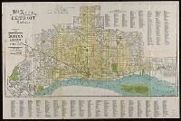
"Compliments of the Burton Abstract and Title Co.", Coordinates not present on map and are approximated., Illegible manuscript note., and Includes street index.