Astronomy--Study and teaching--Early works to 1800--Facsimiles., Celestial globes--Early works to 1800--Facsimiles., Globes--Early works to 1800--Facsimiles., and Navigation--Study and teaching--Early works to 1800--Facsimiles
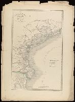
Appears in Giuseppe La Farina's history of Italy published 1851-1852 by Societa editrice italiana. and In lower left: La-Farina : Storia d'Italia dal 1815 al 1850.
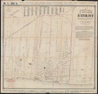
Guide map of the city of Detroit showing location of hotels, churches, schools, railroad depots and all places of interest
Description:
Advertisements on verso., Arc distances measured from Campus Martius., Coordinates not present on map and are approximated., Includes text on rates of fare for public carriages., Inset: Junction of Grand Trunk, Michigan Central, and Michigan Southern railroads., North oriented toward upper right., and Shows ferry lines to Windsor, railroad lines, points of interest.
Appeared in Valk and Schenk's Atlantis sylloge compendiosa, ca. 1702., Backed with paper. Ms. no. "29" in upper left-hand corner. Sheet measures 53.5 x 62.5 cm. No. 29 of 87 maps bound together., Includes five bar scales., Prime meridian: Ferro., Relief shown pictorially., and Watermark.
Publisher:
Gerard Valk,
Subject (Geographic):
Switzerland--Maps--Early works to 1800.
Subject (Name):
Schenk, Peter, 1660-1718 or 1719. Atlantis sylloge compendiosa. and Valck, G. (Gerard), 1651 or 1652-1726. Atlantis sylloge compendiosa.
I haue heere added for the readers profit and delight this map of Iapan, published by I. Hondivs, I have heere added for the readers profit and delight this map of Iapan, published by I. Hondius, and Japan I.
Description:
Relief shown pictorially., Removed from Samuel Purchas's Purchas his Pilgrimage (1625)., and Text in English on verso with signature 3M3 at foot of map.
Publisher:
[Printed by William Stansby for Henrie Fetherstone],
Subject (Geographic):
Japan--Maps--Early works to 1800.
Subject (Name):
Featherstone, Henry, -1647, bookseller., Purchas, Samuel, 1577?-1626. Purchas his Pilgrimage. 1625., and Stansby, William, active 1597-1638, printer.
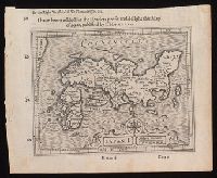
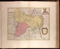
Backed with paper. Ms. no. "70" in upper right corner. Sheet measures 53.6 x 63.3 cm. No. 65 of 87 maps bound together., Bar scale given in "miglia cinque.", and Relief shown pictorially.
Publisher:
Joan Blaeu,
Subject (Geographic):
Belluno (Italy : Province)--Maps--Early works to 1800.
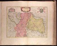
Backed with paper. Ms. no. "69" in upper right corner. Sheet measures 53.5 x 62.5 cm. No. 64 of 87 maps bound together., Bar scale given in "miglia cinque.", and Relief shown pictorially.
Publisher:
Joan Blaeu,
Subject (Geographic):
Italy, Northern--Maps--Early works to 1800. and Veneto (Italy)--Maps--Early works to 1800.
From: Atlas national illustre / V. Levasseur., In bottom left margin: Impie. Lemercier, rue de Seine 57 - Paris., In bottom right margin: La geographie gravee par A. Piat., In top right margin: Emisphere Austral no. 88., Insets: Parny -- Bertin., and Map of Reunion showing major rivers. Relief shown by hachures and spot heights.
Publisher:
Chez l'Editeur Rue de la Parcheminerie, 15,
Subject (Geographic):
Réunion--Maps.
Subject (Name):
Lemercier, active 1838-1875., Levasseur, V. (Victor). Atlas national illustre., and Piat, A.
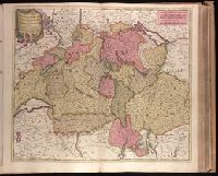
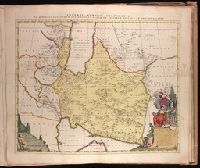
Appeared in Peter Schenk's Atlas contractus., Backed with paper. Ms. no. "90" in upper right-hand corner. Sheet measures 53.6 x 62.7 cm. No. 82 of 87 maps bound together., Bar scale given in "milliaria Germanica.", Prime meridian: Ferro., Relief shown pictorially., Watermark., and With dedication to
Publisher:
Ex formis [Pe]tri Schenk,
Subject (Geographic):
Iran--Maps--Early works to 1800. and Middle East--Maps--Early works to 1800.
Subject (Name):
Schenk, Peter, 1660-1718 or 1719. Atlas contractus. and Witsen, Nicolaas, 1641-1717.