Skip to search
Skip to main content
Skip to first result
Search
You Searched For
Extent of Digitization
Completely digitized
Format
cartographic
Language
Polish
New Search
Search Results
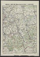
Published / Created:
[1930?]
Call Number:
356 1930
Container / Volume:
BRBL_00114
Image Count:
1
Resource Type:
Maps, Atlases & Globes
Publisher:
Drukarnia Grafia J. Nowak i Ska,
Subject (Geographic):
Cieszyn (Poland : Powiat)--Maps
Found in:
Beinecke Rare Book and Manuscript Library > Cieszyn i Zaolzie (mapa samochodowa i turystyczna) / rysował i wydał Bronisław Stlasny.
Creator:
Published / Created:
1775
Call Number:
1983 Folio 23
Collection Title:
[Atlas factice of 50 maps, primarily by Johann Baptist Homann and/or issued by the Homann Erben
Image Count:
1
Publisher:
Impensis Homannianorum Haeredum
Subject (Geographic):
Bohemia (Czech Republic) --Maps --Early works to 1800, Galicia (Poland and Ukraine) --Maps --Early works to 1800, and Ukraine --Maps --Early works to 1800
Collection Created:
[Nuremberg : Homann Erben, 1710-1786]
Found in:
Beinecke Rare Book and Manuscript Library > Lubomeriae et Galliciae regni tabula geographica / [cartographic material] / F.I.G
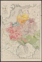
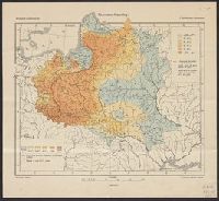
Published / Created:
[1919?].
Call Number:
11hcf 1919B-1
Image Count:
1
Resource Type:
Maps, Atlases & Globes
Description:
Legend indicates ethnic groups and political frontiers.
Publisher:
Wydawnictwo Biura Pracy Spolecznej,
Subject (Geographic):
Europe, Central--Maps
Subject (Topic):
Ethnology
Found in:
Beinecke Rare Book and Manuscript Library > Ludność Ziem Polskich / Lit. W. Główczewski.
Creator:
Published / Created:
1931
Call Number:
356cb L98 1931
Container / Volume:
BRBL_00115
Image Count:
1
Resource Type:
Maps, Atlases & Globes
Description:
Relief shown by contours and spot heights.
Publisher:
Ksi*a*znica-Atlas S.A.,
Subject (Geographic):
Lʹviv Region (Ukraine)--Maps
Found in:
Beinecke Rare Book and Manuscript Library > Mapa okolic Lwowa = [Map of the environs of Lwow] / Instytut kartograficzny Prof. E. Romera.
Published / Created:
1936
Call Number:
30gmm 1936
Container / Volume:
BRBL_00038
Image Count:
1
Resource Type:
Maps, Atlases & Globes
Description:
List of radio stations on border of map.
Publisher:
Wojskowego Inst. Geograficznego
Subject (Geographic):
Europe--Maps
Found in:
Beinecke Rare Book and Manuscript Library > Mapa radjokomunikacyjna Europy
Creator:
Published / Created:
c1923.
Call Number:
356 1923
Container / Volume:
BRBL_00114
Image Count:
1
Resource Type:
Maps, Atlases & Globes
Description:
"Made in USA.", Sep. into two sheets., and Text: "Podział Administracyjny Rzeczypospolitej Polskiej na Województwa i Powiaty."
Publisher:
Geographical Pub. Co.,
Subject (Geographic):
Poland--Administrative and political divisions--Maps
Found in:
Beinecke Rare Book and Manuscript Library > Rzeczpospolita Polska : w granicach obecnych z Podziałem na Województwa i z Wyszczególnieniem Wszystkich miast Powiatowych.
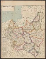
Published / Created:
[1919?]
Call Number:
11hcf 1919B-23
Container / Volume:
BRBL_00010Q
Image Count:
1
Resource Type:
Maps, Atlases & Globes
Description:
Indicates the percentages of Roman Catholics and Jews in the area covered by modern-day Poland, Belarus, and the Ukraine.
Publisher:
G. Freytag & Berndt,
Subject (Geographic):
Europe, Eastern--Maps
Subject (Topic):
Ethnology--Europe, Eastern--Maps and Religions--Europe, Eastern--Maps
Found in:
Beinecke Rare Book and Manuscript Library > Rzymsko-Katolicy = Römisch-Katholische = Catholiques Romains / Opracował E. Romer.
Creator:
Published / Created:
1945
Call Number:
3562 1945
Container / Volume:
BRBL_00115
Image Count:
1
Resource Type:
Maps, Atlases & Globes
Description:
Imperfect: mutilated on left side, with some loss of text. and Includes three inset maps.
Publisher:
Wydawnictwa Instytutu Śląskiego,
Subject (Geographic):
Silesia--Maps and Wrocław Region (Poland)--Maps
Found in:
Beinecke Rare Book and Manuscript Library > Śląsk : mapa fizyczna-administracyjna ... / opracowli Józef Szaflarski i Antoni Wrzosek.
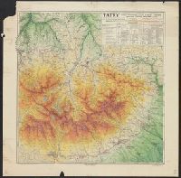
Creator:
Published / Created:
c1931.
Call Number:
356 T18 1931
Container / Volume:
BRBL_00114
Image Count:
1
Resource Type:
Maps, Atlases & Globes
Alternative Title:
Tatry
Description:
"12.31"--Lower right margin., "Nakład i druk Ski Akc."--Lower right border., and Major towns/cities/resorts shown on the map include Zakopane, Jaworzyna, Podspady, Żar czyli Żdziar, Jaskinie Bielskie, Matlary, Lomnica Tatrazanska, Stary Smokowiec, Nowy Smokow
Publisher:
Ksia̜żnica-Atlas, Zjednoczone Zakłady Kartograficzne i Wydawnicze T.N.S.W.,
Subject (Geographic):
Tatra Mountains (Slovakia and Poland)--Maps
Subject (Topic):
Skis and skiing--Tatra Mountains (Slovakia and Poland)--Maps
Found in:
Beinecke Rare Book and Manuscript Library > Tatry Cze̜ść Wschodnia, Tatry Wysokie i Bielskie / opracowal Tadeusz Zwoliński w Zakopanem.
Creator:
Published / Created:
1993
Call Number:
356 W249 1993
Container / Volume:
BRBL_00114
Image Count:
2
Resource Type:
Maps, Atlases & Globes
Alternative Title:
Warszawa, city map, Warszawa, Plan de la ville, Warszawa, plan goroda, and Warszawa, Stadtplan
Description:
No. on panel: 33-192-03.
Subject (Geographic):
Warsaw (Poland)--Maps
Found in:
Beinecke Rare Book and Manuscript Library > Warszawa, plan miasta = Warszawa, city map = Warszawa, Stadtplan = Warszawa, Plan de la ville = Warszawa, plan goroda.
Branch:v1.61.6 ,Deployed:2024-06-12T09:55:33-04:00