Skip to search
Skip to main content
Skip to first result
Search
You Searched For
Publication Place
London :
New Search
Search Results
Creator:
Published / Created:
30th Septr. 1780.
Call Number:
27 1780
Container / Volume:
BRBL_00683
Image Count:
1
Resource Type:
Maps, Atlases & Globes
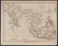
Description:
"Jn. Lodge, sculp." and Mounted on linen. Cross Collection 70.
Publisher:
Published ... by J. Bew, Pater Noster Row,
Subject (Geographic):
East Indies--Maps--Early works to 1800
Subject (Name):
Bew, John, -1793
Found in:
Beinecke Rare Book and Manuscript Library > A map of the East Indies [cartographic material] : from the best authorities.
Published / Created:
1788
Call Number:
367 1788
Container / Volume:
BRBL_00145
Image Count:
1
Resource Type:
Maps, Atlases & Globes
Publisher:
Robert Sayer,
Subject (Geographic):
Brandenburg--Maps--Early works to 1800
Found in:
Beinecke Rare Book and Manuscript Library > A map of the Electorate of Brandenburg, including Western Pomerania and the greatest part of the Dutchies of Mecklenburg and Magdeburg.
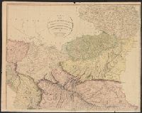
Published / Created:
1804
Call Number:
53 1804
Container / Volume:
BRBL_00284
Image Count:
4
Resource Type:
Maps, Atlases & Globes
Publisher:
A. Arrowsmith,
Subject (Geographic):
Middle East--Maps
Found in:
Beinecke Rare Book and Manuscript Library > A map of the Environs of Constantinople ... A. Arrowsmith 1801 and 1804.
Published / Created:
[1794?]
Call Number:
36 1794
Container / Volume:
BRBL_00119
Image Count:
1
Resource Type:
Maps, Atlases & Globes
Publisher:
Bowles & Carver,
Subject (Geographic):
Germany--Maps--Early works to 1800
Found in:
Beinecke Rare Book and Manuscript Library > A map of the German Empire divided into its circles to which is added the Kingdom of Prussia ... By L. de la Rochette.
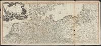
Creator:
Published / Created:
[1759]
Call Number:
1977 Folio 177
Image Count:
2
Resource Type:
Maps, Atlases & Globes
Alternative Title:
Electorate of Brunswick-Luneburg with its dependencies
Description:
Imperfect: torn along fold, with some loss of text. Sheet measures 75.0 x 62.4 cm. No. 30 of 34 maps bound together., Inset map: Plan of the battle of Minden on the 1st of August 1759., Prime meridian: Ferro., and Relief shown pictorially.
Publisher:
Thos. Jefferys,
Subject (Geographic):
Lower Saxony (Germany)--Maps--Early works to 1800
Subject (Topic):
Minden, Battle of, Germany, 1759--Maps
Found in:
Beinecke Rare Book and Manuscript Library > A map of the King of Great Britain's Dominions in Germany, or, The Electorate of Brunswick-Lunenburg with its dependencies [cartographic material] : containing the Dutchies of Lunenburg, Calenberg, Grunbenhagen, Lauenburg, Bremen & Verden, and the countie
Published / Created:
1783
Call Number:
38 1783
Container / Volume:
BRBL_00151
Image Count:
2
Resource Type:
Maps, Atlases & Globes
Publisher:
J. Bew,
Subject (Geographic):
France--Maps--Early works to 1800
Found in:
Beinecke Rare Book and Manuscript Library > A map of the Kingdom of France, ... Jno. Lodge sculp.
Published / Created:
[1802?]
Call Number:
39 1802
Container / Volume:
BRBL_00186
Image Count:
2
Resource Type:
Maps, Atlases & Globes
Publisher:
John Bowles and Carington Bowles,
Subject (Geographic):
Spain--Maps
Found in:
Beinecke Rare Book and Manuscript Library > A map of the Kingdoms of Spain and Portugal according to DeLisle ...
Creator:
Published / Created:
March 1st 1785.
Call Number:
49 1785
Container / Volume:
BRBL_00267
Image Count:
2
Resource Type:
Maps, Atlases & Globes
Description:
Also appeared in Faden's General atlas. London : William Faden, 1811?., Includes ornamental cartouche., Prime meridians: Ferro and London., Relief shown pictorially., and Sheets fit together with overlap.
Publisher:
Printed for Wm. Faden, Charing Cross,
Subject (Geographic):
Mediterranean Sea--Maps--Early works to 1800
Subject (Name):
Abbot, Charles,--Baron Colchester,--1757-1829--Bookplate and Faden, William, 1749-1836. General atlas
Found in:
Beinecke Rare Book and Manuscript Library > A map of the Mediterranean Sea, with the adjacent regions and seas in Europe, Asia, and Africa / by William Faden.
Published / Created:
1793
Call Number:
38 1793
Container / Volume:
BRBL_00153
Image Count:
1
Resource Type:
Maps, Atlases & Globes
Publisher:
William Faden,
Subject (Geographic):
France--Maps--Early works to 1800
Found in:
Beinecke Rare Book and Manuscript Library > A map of the Northern part of France ... to facilitate the knowledge of the operations ... by the Allied Armies against the French ...
Published / Created:
1793
Call Number:
38 1793A
Container / Volume:
BRBL_00153
Image Count:
1
Resource Type:
Maps, Atlases & Globes
Publisher:
William Faden,
Subject (Geographic):
France--Maps--Early works to 1800
Found in:
Beinecke Rare Book and Manuscript Library > A map of the Northern part of France [and part of Belgium] to facilitate the knowledge ... by the Allied Armies against the French ...
Branch:v1.61.6 ,Deployed:2024-06-12T09:55:31-04:00