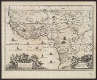
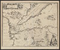
Covers coastal western and central Africa from Sierra Leone to Gabon., From Ogilby's Africa, being an accurate description of the regions, Includes ill. and decorative cartouche., Relief shown pictorially., and Verso: stamped "Map Collection Yale Univ. Library".
Publisher:
Printed by T. Johnson for the author,
Subject (Geographic):
Africa, Central--Maps--Early works to 1800 and Africa, West--Maps--Early works to 1800
Subject (Name):
Ogilby, John, 1600-1676. Africa, being an accurate description of the regions of Egypt, Barbary, Lybia and Billedulgerid
Subject (Topic):
Coasts--Africa, Central--Maps--Early works to 1800 and Coasts--Africa, West--Maps--Early works to 1800
"Iohan. Senex scu, Imprint derived from other maps in the same atlas., London meridian., Ms. no. on verso: 34. Sheet measures 53 x 68 cm. Cross Collection no. 96., Relief shown pictorially., and Shows boundaries, forests, rivers, roads and settlements, with notes.
Publisher:
John Senex,
Subject (Geographic):
Mediterranean Region--Historical geography--Early works to 1800--Maps
Subject (Name):
Senex, John, d. 1740. New general atlas
Subject (Topic):
Ecclesiastical geography--Africa, North--Maps--Early works to 1800
Ogilby, John, 1600-1676 Ogilby, John, 1600-1676. Africa, being an accurate description of the regions of Egypt, Barbary
Published / Created:
1670]
Call Number:
299 1670
Container / Volume:
BRBL_00028
Image Count:
1
Resource Type:
Maps, Atlases & Globes
Description:
From Ogilby's Africa, being an accurate description of the regions of Egypt, Barbary, Lybia and Billedulgerid. 1670., Has watermarks., Includes ill. and decorative cartouche., and Relief shown pictorially.
Ogilby, John, 1600-1676 Ogilby, John, 1600-1676. Africa, being an accurate description of the regions of Egypt, Barbary
Published / Created:
1670]
Call Number:
214 1670
Image Count:
1
Resource Type:
Maps, Atlases & Globes
Description:
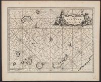
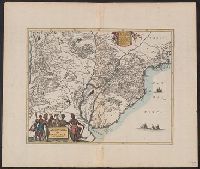
Covers the Canary Islands and Madeira Islands., From Ogilby's Africa, being an accurate description of the regions of Egypt, Barbary, Lybia and Billedulgerid. 1, Has watermarks., Includes ill., rhumb lines, and decorative cartouche., and Relief shown pictorially.
Publisher:
Printed by T. Johnson for the author,
Subject (Geographic):
Canary Islands--Maps--Early works to 1800 and Madeira Islands--Maps--Early works to 1800
Subject (Topic):
Nautical charts--Canary Islands--Early works to 1800 and Nautical charts--Madeira Islands--Early works to 1800
Ogilby, John, 1600-1676 Ogilby, John, 1600-1676. Africa, being an accurate description of the regions of Egypt, Barbary
Published / Created:
1670]
Call Number:
213 1670
Image Count:
1
Resource Type:
Maps, Atlases & Globes
Description:
From Ogilby's Africa, being an accurate description of the regions of Egypt, Barbary, Lybia and Billedulgerid. 1670., Has watermarks., Includes ill. and decorative cartouche., and Relief shown pictorially.
From Ogilby's Africa, being an accurate description of the regions of Egypt, Barbary, Lybia and Billedulgerid. 1670., Has watermarks., Includes ill. and decorative cartouche., and Relief shown pictorially.
Publisher:
Printed by T. Johnson for the author,
Subject (Geographic):
Africa, Central--Maps--Early works to 1800 and Africa, West--Maps--Early works to 1800
Subject (Name):
Ogilby, John, 1600-1676. Africa, being an accurate description of the regions of Egypt, Barbary, Lybia and Billedulgerid
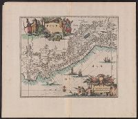
From Ogilby's Africa, being an accurate description of the regions of Egypt, Barbary, Lybia and Billedulgerid. 1670., Has watermarks., Includes ill. and decorative cartouche., Oriented with north to the left., and Relief shown pictorially.
Publisher:
Printed by T. Johnson for the author,
Subject (Geographic):
Egypt--Maps--Early works to 1800
Subject (Name):
Ogilby, John, 1600-1676. Africa, being an accurate description of the regions of Egypt, Barbary, Lybia and Billedulgerid
Another copy in Ogilby's America, call no. EDg. 671, in RBR., Copper engraving, shows central South America, modern Uruguay, Paraguay, most of Bolivia, parts of Chile, Peru, Argentina, Brazil; settlements of various types, towns, cities; forests, mountains shown by pictorial hachuring., Decorative title cartouche, natives, animals, ect. Secondary cartouche contains explanatory notes. Single vessel off the coast with a naval battle below it. Decorative features have been colored by hand recently. Wide margins show provenance. Copies from mountains usually trimmed., From Ogilby, John, America, London, 1671. Originally published in Montanus, Arnoldus, Die Nieuwe en Onbekende Weereld, Amsterdam, Jacob van Meurs, 1671., and Protoype map with same title in Blaeu, Jan, Le Gran Atlas, ou Cosmographie Blaviane, Amsterdam, 1663, vol. 12, ... L'Amérique.
From Ogilby, John, America, London 1671. Originally published in Montanus, Arnoldus, Die Nieuwe en Onbekende Weereld, Amsterdam, Jacob van Meurs, 1671.