Les voyages de la Novvelle France occidentale, dicte Canada / faits par le Sr. de Champlain
Image Count:
1
Alternative Title:
Carte de la Nouuelle France.
Description:
Housed and classed separately as BrSides Folio 2008 15., In pencil on verso: Beinecke / Library / Broadsides / Folio / 2008 / 15 [(not digitized)]., Map formerly bound in facing p. 310 of Z6 14., Map formerly mounted on linen and folded., Scale [ca. 1:1,000,000]., and Teaching resource: Professor John Mack Faragher, History 141: The American West.
Subject (Geographic):
America--Discovery and exploration--French, Canada--Discovery and exploration, and Canada--Maps
Subject (Topic):
Indians of North America and Navigation--Early works to 1800
Collection Created:
A Paris : Chez Pierre LeMvr, dans la grand' salle du Palais, M.DC.XXXII. [1632]
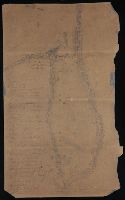
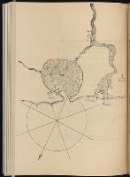
An atlas of Korea. This is an atlas of Chosŏn dynasty, and can be considered a follow-up version of the Tongguk chido (東國地圖), or the Map of Korea, drawn by Chŏng Sang-gi (鄭尚驥, 1678-1752), which has been evaluated as an outstanding accomplishment in the history of cartography. The atlas consists of a complete map of Korea, and eight maps for the provinces. The complete map of Korea is a down-scaled version in smaller size. As to the maps of each province, Kyŏnggi Province and Ch'ungch'ŏng Province were drawn in one piece, while Hamgyŏng Province, larger in area, was rendered in two pieces; northern and southern Hamgyŏng Province. A scale of one hundred ri (里) to one cha (尺) was applied and marked accurately on each of the provincial maps. The introduction of accurate scale to the map was one of the most striking features of Chŏng Sang-gi's Map of Korea. Also noteworthy are the elaborate rendering of the demarcation lines of the northern borders, and the detailed representation of the land and the sea routes, which are also the characteristics of Chŏng Sang-gi's maps. This atlas is presumed to be a copy of one that was produced before 1767 because the town names of Anŭm (安陰) and Sanŭm (山陰) of Kyŏngsang Province are given using earlier names instead of the new names adopted in that year. Other distinguishing features are that Paegyagot (白也串) in the east of Hŭngyang (興陽), Chŏlla Province is represented as an island instead of a promontory, that there is a lake near Sŏgwip'o in Cheju Island, and that the place names are marked on the northern banks across the Amnok River (鴨綠江) and Tuman River (豆滿江), which had previously been left blank. These attest to the fact that this atlas was produced or at least is a copy of one that was produced in between the original version of Chŏng Sang-gi's Map of Korea and its revised version. and 전도와8도의지도를엮음.
Alternative Title:
Chidoch'ŏp, Jido cheop, 지도첩, and 地圖帖, [Late Chosŏn i.e. 18th century].
Description:
In Korean (Hanmun)., Manuscript, in an unidentified hand., and Yale Association of Japan Collection original call number: Db11.
Subject (Topic):
Korean manuscripts and Yale Association of Japan Collection
This collection documents the establishment and early years of the Puget Mill Company, which manufactured lumber. The bulk of the papers are letters from Josiah Keller to his partner, Charles Foster. They discuss building plans, business development, ships and cargoes, and accounts. There are occasional mentions of Keller's personal affairs and one letter describes his voyage around Cape Horn in the schooner L. P. Foster. Two charts show Hood's Canal, the harbor, and location of the mill.
Alternative Title:
Puget Mill Company, 2 charts
Description:
Capt. Josiah P. Keller, of East Machias, Maine, was a founder of the Puget Mill Company. He sailed on the Julius Pringle from San Francisco to Puget Sound where he chose Port Gamble as a site for the mill. Keller became superintendent of the mill and in 1853 moved his family to Port Gamble.
Subject (Geographic):
Port Gamble (Wash.), Puget Sound (Wash.), and Washington (State)--Economic conditions
Subject (Name):
Foster, Charles,--d. 1876, Julius Pringle (Ship), Keller, Josiah P.,--1812-1862, L. P. Foster (Schooner), Pope, Andrew J, Puget Mill Company, and Talbot, William C
Alpagot, Haydar Ayasofya Kütüphanesi. Manuscript. 2612 Kurtoğlu, Fevzi Pekol, Fehmi Pirı̂ Reis, d. 1554? Türk ve İslâm Eserleri Müzesi. Manuscript. Turkish 403
Published / Created:
1935
Call Number:
1977 +68
Image Count:
2
Resource Type:
Maps, Atlases & Globes
Alternative Title:
Türk Tarihi Arastirma Kurumu yayinlarindan, no. 2
Description:
"Bahriye kitabinin metni, Istanbulda Ayasofya kitapsarayinda 2612 sayida kayitli nüshasindan faksimile edilmiştir. Onsöz ... Fevzi Kurdoglu ve Haydar Alpagot tarafindan yazilmis ve indeks ... Fehmi Pekol tarafindan yapilmiştir." -- from verso of t.p., "Bakilan kitablar": p. [lvii], "Bu kitabin kabi için, 1617 yilinda hattat Halit tarafindan yazilmiş ve Ahmet I. in türbesine konulmus olan yazma bir kuranin kabi örnek utulmuştur. Bu örnek simdi Istanbulda Türk Islâm eserleri müzesinde 403 numarada kayitlidir." -- from verso of leaf [1] following page f., and "Indeks": 72 p. at end.
Publisher:
Devlet Basimevi,
Subject (Geographic):
Marmara, Sea of (Turkey), Mediterranean Region--Description and travel, and Mediterranean Sea--Navigation
Subject (Name):
Columbus, Christopher
Subject (Topic):
Manuscripts, Turkish--Facsimiles and Nautical charts--Mediterranean Sea
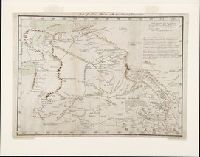
Manuscript map, in color, drawn by Bernardo Miera y Pacheco in San Felipe, Chihuahua, Mexico, in 1778. It reveals Spain's northernmost efforts to explore the interior of western North America on the Domínguez-Escalante Expedition, including present day New Mexico, Colorado, Utah, and Arizona.
Description:
Bernardo Miera y Pacheco was the cartographer on the Domínguez-Escalante Expedition. The expedition of ten men, led by Franciscan Fathers Francisco Atanasio Domínguez and Silvestre Vélez de Escalante, departed Sante Fe in late July 1776 and returned there on 2 January 1777., Note in later hand at upper edge of map: "Map of New Mexico with the latest discoveries.", and Scale [ca. 1:3,250,000] (W 112⁰ W 105⁰/N 40⁰ N 34⁰). Bar scale given in "leguas reguladas las marchas por tierra." Coordinates on map as: W260 W273/N42 N35.
Subject (Geographic):
Arizona--Maps--Early works to 1800, Colorado--Maps--Early works to 1800, New Mexico--Maps--Early works to 1800, Southwest, New--Maps--Early works to 1800, and Utah--Maps--Early works to 1800
Subject (Name):
Domínguez, Francisco Atanasio, active 1776, Domínguez-Escalante Expedition (1776), Miera y Pacheco, Bernardo de, and Vélez de Escalante, Silvestre, -1792
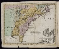
A new map of North America: shewing the advantages obtain'd therein to England, by the peace. and Gentleman's monthly companion
Description:
Includes essays, songs, poetry, British and foreign news, bankrupts, translations and reprints on various subjects., Individual issues lack imprint., Title vignettes (royal coat of arms)., Two vols. a year, 1759-1767; 1 vol. a year, 1768-1771; ceased publication with v. 21, 1771., Vols. 1-2 include supplements., and Volumes have numerical designation only.
Publisher:
Printed for J. Coote,
Subject (Geographic):
America--Maps--Early works to 1800, East (U.S.)--Maps--Early works to 1800, Great Britain--Description and travel--Periodicals--Early works to 1800, Louisiana Purchase--Maps, and United States--Maps--Early works to 1800
Subject (Topic):
English literature--Periodicals--Early works to 1800 and Periodicals--England
Charts and title pages in English, text in Dutch., Map oriented with North at bottom left., and Volvelle on p. [17].
Publisher:
Jodocus Hondius excudit,
Subject (Geographic):
Europe --Maps --Early works to 1800, Great Britain --Maps --Early works to 1800, Netherlands --Maps --Early works to 1800, and North Sea --Maps --Early works to 1800
Des Barres, Joseph F. W. (Joseph Frederick Wallet), 1722-1824
Published / Created:
1775?-1781?]
Call Number:
1983 Folio 25
Image Count:
3
Resource Type:
Maps, Atlases & Globes
Abstract:
A made-up collection of charts, plans and views, partly hand colored, from the Atlantic Neptune comprising [v. 1]: the charts of the South East Coast of Nova Scotia, with the title page of The charts of the coast and harbors of New England, 1781 bound in front (31 items, dated between 1777 and 1781). [v. 2]: Charts of the coast and harbours in the Gulph and river of St. Lawrence, 1780, including the charts of the coast of New England (36 items, dated between 1775 and 1781). [v. 3]: Charts of several harbours and divers parts of the coast of North America from New York south westwards to the Gulph of Mexico, 1780, including some 16 charts belonging to the New England part of the work (35 items, dated between 1776 and 1781). General title page wanting.
Description:
Includes indexes.
Publisher:
The Admiralty,
Subject (Geographic):
North America--Maps and North America--Pictorial works