Search
You Searched For
Search Results
- Creator:
- Sanborn Map Company, issuing body
- Published / Created:
- 1931
- Call Number:
- 766 N472 1931
- Image Count:
- 11
- Resource Type:
- Maps, Atlases & Globes
- Found in:
- Beinecke Rare Book and Manuscript Library > New Milford, Litchfield County, Connecticut.
- Creator:
- Geo. W. Stadly & Co
- Published / Created:
- [186-?]
- Call Number:
- 754hc 1862C
- Container / Volume:
- BRBL_00421
- Image Count:
- 13
- Resource Type:
- Maps, Atlases & Globes
- Found in:
- Beinecke Rare Book and Manuscript Library > [13 maps showing positions of the Union and Confederate armies during the year 1862] / drawn and printed by Geo. W. Stadly & Co.
- Published / Created:
- [1920?]
- Call Number:
- 515 1920
- Container / Volume:
- BRBL_00707
- Image Count:
- 13
- Resource Type:
- Maps, Atlases & Globes
- Found in:
- Beinecke Rare Book and Manuscript Library > [Manuscript maps showing ruin sites etc. in the Transjordan and adjacent areas].
- Published / Created:
- 1888
- Call Number:
- 32 Ox1 1768
- Container / Volume:
- BRBL_00052A
- Image Count:
- 20
- Resource Type:
- Maps, Atlases & Globes
- Found in:
- Beinecke Rare Book and Manuscript Library > Sixteen Old Maps of Properties in Oxfordshire (with one in Berkshire) ... Illustrating the open field system. 1605-1768.
- Creator:
- Assam (India). Survey Office
- Published / Created:
- [1943?]
- Call Number:
- 59gm As72 1943
- Container / Volume:
- BRBL_00319
- Image Count:
- 21
- Resource Type:
- Maps, Atlases & Globes
- Found in:
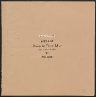
- Beinecke Rare Book and Manuscript Library > Map of Assam showing roads & railways
- Creator:
- Dripps, M. (Matthew)
- Published / Created:
- 1868
- Call Number:
- 771 N49 1868D
- Container / Volume:
- BRBL_00487
- Image Count:
- 21
- Resource Type:
- Maps, Atlases & Globes
- Found in:
- Beinecke Rare Book and Manuscript Library > Plan of New York City from the Battery to Spuyten Duyvil Creek : showing every lot and building thereon; old farm lines, street numbers at the corners of blocks, railroads, steamboat landings, bulkhead and pier lines, etc., etc., etc. / based on the surve
- Creator:
- King, Nicholas, d. 1812
- Published / Created:
- [1888]
- Call Number:
- 779 W27 1803
- Container / Volume:
- BRBL_00505
- Image Count:
- 19
- Resource Type:
- Maps, Atlases & Globes
- Found in:
- Beinecke Rare Book and Manuscript Library > The King plats of the city of Washington in the District of Columbia 1803.
- Creator:
- Maury, Matthew Fontaine, 1806-1873
- Published / Created:
- [1847?]-1853.
- Call Number:
- 11cfk 1850A-3
- Container / Volume:
- BRBL_00768
- Image Count:
- 4
- Resource Type:
- Maps, Atlases & Globes
- Found in:
- Beinecke Rare Book and Manuscript Library > Wind and current chart of the South Atlantic [cartographic material] / by M.F. Maury, L.L.D.U.S. Navy, Superindt. of U.S.N. Observatory ; compiled from materials in the Bureau of Ordnance and Hydrography, Commodore Charles Morris, Chief of Bureau.
- Creator:
- Maury, Matthew Fontaine, 1806-1873
- Published / Created:
- 1852
- Call Number:
- 11cfk 1850D-2
- Container / Volume:
- BRBL_00773
- Image Count:
- 4
- Resource Type:
- Maps, Atlases & Globes
- Found in:
- Beinecke Rare Book and Manuscript Library > Wind and current chart of the South Atlantic [cartographic material] / by M.F. Maury, L.L.D. Lieut. U.S. Navy, Superint'dt. of U.S.N. Observatory ; compiled from materials in the Bureau of Ordnance and Hydrography, Commodore Charles Morris, Chief of Bureau.
- Creator:
- Walling, Henry Francis, 1825-1888
- Published / Created:
- 1858, c1856.
- Call Number:
- 763 Or1 1858
- Container / Volume:
- BRBL_00452
- Image Count:
- 4
- Resource Type:
- Maps, Atlases & Globes
- Found in:
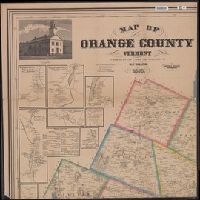
- Beinecke Rare Book and Manuscript Library > Map of Orange County, Vermont / from surveys under the direction of H.F. Walling ; engraved, printed, colored & mounted at H.F. Walling's map establishment.