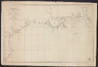
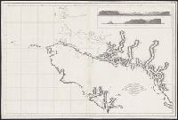
"Juan Moreno Tejada la grabó.", From Atlas marítimo español. 1789-1814., In upper right margin: Numo. Io., Includes text and inset of "Canal de la salida de las goletas, visto al este.", and Shows area around Vancouver Island (B.C.) and Strait of Juan de Fuca.
Publisher:
s.n.,
Subject (Geographic):
Juan de Fuca, Strait of (B.C. and Wash.)--Maps--Early works to 1800, Pacific Coast (B.C.)--Maps--Early works to 1800, Pacific Coast (Wash.)--Maps--Early works to 1800, and Vancouver Island (B.C.)--Maps--Early works to 1800
Subject (Name):
Arnold, Robert M.--Ownership, Moreno Tejada, Juan, Spain. Dirección de Hidrografía. Atlas marítimo español, and Valdés Flores Bazán y Peón, Cayetano, 1767-1835
"Juan Moreno Tejada la grabó.", From Atlas marítimo español. 1789-1814., From the collection of Robert M. Arnold., In upper right margin: Numo. Io., Includes text and inset of "Canal de la salida de las goletas, visto al este.", and Shows a
Publisher:
s.n.,
Subject (Geographic):
Juan de Fuca, Strait of (B.C. and Wash.)--Maps--Early works to 1800, Pacific Coast (B.C.)--Maps--Early works to 1800, Pacific Coast (Wash.)--Maps--Early works to 1800, and Vancouver Island (B.C.)--Maps--Early works to 1800
Subject (Name):
Arnold, Robert M.--Ownership, Moreno Tejada, Juan, Spain. Dirección de Hidrografía. Atlas marítimo español, and Valdés Flores Bazán y Peón, Cayetano, 1767-1835
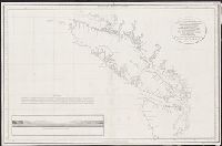
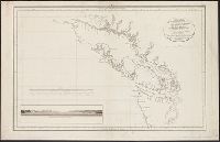
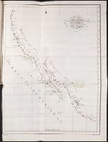
Vista de la entrada de Nutka, demorando la Pta. A. al N. 27⁰ E. del mundo distancia 21 millas. and Vista del Cabo Frondoso, demorando el Yslote A al N. 37⁰ O. distancia 12 1/2 millas, B. Cabo Frondoso.
Description:
Includes inset of "Vista de la entrada de Nutka, demorando la Pta. A. al N. 27⁰ E. del mundo distancia 21 millas ... " and "Vista del Cabo Frondoso, demorando el Yslote A al N. 37⁰ O. distancia 12 1/2 millas, B. Cabo Frondoso.", Relief shown pictorially., and S
Publisher:
s.n.,
Subject (Geographic):
Pacific Coast (B.C.)--Maps--Early works to 1800 and Vancouver Island (B.C.)--Maps--Early works to 1800
Subject (Name):
Alcalá-Galiano, Dionisio, 1760-1805, Arnold, Robert M.--Ownership, Ballester, Joaquin, Spain. Dirección de Hidrografía. Atlas marítimo español, and Valdés Flores Bazán y Peón, Cayetano, 1767-1835
Vista de la entrada de Nutka, demorando la Pta. A. al N. 27⁰ E. del mundo distancia 21 millas. and Vista del Cabo Frondoso, demorando el Yslote A al N. 37⁰ O. distancia 12 1/2 millas, B. Cabo Frondoso.
Description:
Includes inset of "Vista de la entrada de Nutka, demorando la Pta. A. al N. 27⁰ E. del mundo distancia 21 millas ... " and "Vista del Cabo Frondoso, demorando el Yslote A al N. 37⁰ O. distancia 12 1/2 millas, B. Cabo Frondoso.", Relief shown pictorially., and W
Publisher:
s.n.,
Subject (Geographic):
Pacific Coast (B.C.)--Maps--Early works to 1800 and Vancouver Island (B.C.)--Maps--Early works to 1800
Subject (Name):
Alcalá-Galiano, Dionisio, 1760-1805, Arnold, Robert M.--Ownership, Ballester, Joaquin, Spain. Dirección de Hidrografía. Atlas marítimo español, and Valdés Flores Bazán y Peón, Cayetano, 1767-1835
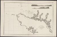
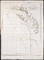
Relacion del viage hecho por las goletas Sutil y Mexicana en el ano de 1792, para reconocer el
Image Count:
1
Subject (Geographic):
California --Maps and Spain --Exploring expeditions
Subject (Name):
Alcala-Galiano, Dionisio, 1760-1805, Mexicana (Ship), Navarrete, Martin Fernandez de, 1765-1844, Sutil (Ship), and Valdes Flores Bazan y Peon, Cayetano, 1767-1835
Relacion del viage hecho por las goletas Sutil y Mexicana en el ano de 1792, para reconocer el
Image Count:
1
Subject (Geographic):
British Columbia --Description and travel, Juan de Fuca, Strait of (B.C. and Wash.), Northwest Coast of North America, Northwest Passage, Spain --Exploring expeditions, and Vancouver Island (B.C.)
Subject (Name):
Alcala-Galiano, Dionisio, 1760-1805, Mexicana (Ship), Navarrete, Martin Fernandez de, 1765-1844, Sutil (Ship), and Valdes Flores Bazan y Peon, Cayetano, 1767-1835