Skip to search
Skip to main content
Skip to first result
Search
You Searched For
Date
-
Repository
Beinecke Rare Book and Manuscript Library
Genre
Maps
Creator
United States. Army Map Service
Found In
Beinecke Rare Book and Manuscript Library
New Search
Search Results
Creator:
Published / Created:
1945
Call Number:
56 F73 1945
Container / Volume:
BRBL_00296
Image Count:
1
Resource Type:
Maps, Atlases & Globes
Alternative Title:
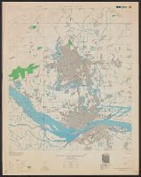
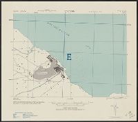
Fu-chou (Foochow) and Nan-t'ai, China, Fukien Province, Fu-chou and Nan-ta̓i, and L901
Description:
"Compiled in 1945 from China 1:50,000 Army Map Service 8833 II (Type C) 1945. Planimetric detail intensifie, Marginal maps: Coverage diagram -- Index to boundaries., Military grid., and Some streets and buildings are named; wooded and cultivated areas are shown.
Publisher:
U.S. Army Map Service,
Subject (Geographic):
Fuzhou (Fujian Sheng, China)--Maps and Nan-t'ai Shi (Fujian Sheng, China)--Maps
Found in:
Beinecke Rare Book and Manuscript Library > China city plans 1:12,500. Fu-chou and Nan-ta̓i / prepared under the direction of the Chief of Engineers by the Army Map Service (AM) ... 1945 [cartographic material].
Creator:
Published / Created:
1942
Call Number:
6547 C74 1945
Container / Volume:
BRBL_00344
Image Count:
1
Resource Type:
Maps, Atlases & Globes
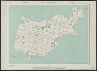
Alternative Title:
Its A.M.S. G941, Senegal 1:5 000 [cartographic material], and Series (Standard map series designation system) ; G941.
Description:
Important streets and buildings are named. and In upper left corner: Senegal 1:5,000.
Publisher:
The Service,
Subject (Geographic):
Conakry (Guinea)--Maps
Found in:
Beinecke Rare Book and Manuscript Library > City plan of Conakry.
Creator:
Published / Created:
1943
Call Number:
38 C71 1943
Container / Volume:
BRBL_00157
Image Count:
1
Resource Type:
Maps, Atlases & Globes
Alternative Title:
France 1:15,000 and Series M961
Description:
"3-43.", "Copied from French map, 1:50,000, Colmar F 37-18, revised to 1926.", "First edition 1943.", A few buildings are named., Military grid., Place names and buildings in French., and Relief show by spot heights.
Publisher:
Army Map Service,
Subject (Geographic):
Colmar (France)--Maps
Found in:
Beinecke Rare Book and Manuscript Library > Colmar [cartographic material] : city plan / prepared under the direction of the Chief of Engineers, U.S. Army, 1943.
Creator:
Published / Created:
[1945]
Call Number:
3897gm 1945
Image Count:
1
Resource Type:
Maps, Atlases & Globes
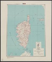
Alternative Title:
Series 6201
Description:
"3/45 ED.", Includes inset defining strategic area., Relif shown by hachures and spot heights., and Shows roads and railroads.
Publisher:
Army Map Service,
Subject (Geographic):
Corsica (France)--Maps
Subject (Topic):
Transportation--France--Corsica--Maps
Found in:
Beinecke Rare Book and Manuscript Library > Corsica [cartographic material] : special strategic map / compiled by the Army Map Service.
Creator:
Published / Created:
1943
Call Number:
39 C812 1943
Container / Volume:
BRBL_00189
Image Count:
1
Resource Type:
Maps, Atlases & Globes
Alternative Title:
[Series] M981 and A.M.S. M981
Description:
"Copied from I. S. I. S. report, 1:2,400, La Coruna, CB 1811, no. 12, 1942.", At head of title: Spain 1:10,000., and Some streets and buildings are named.
Subject (Geographic):
La Coruña (Spain)--Maps
Found in:
Beinecke Rare Book and Manuscript Library > Coruna [cartographic material] : city plan.
Creator:
Published / Created:
1943
Call Number:
4891gmb 1943
Container / Volume:
BRBL_00266
Image Count:
1
Resource Type:
Maps, Atlases & Globes
Alternative Title:
Its A.M.S. ; 6201 and Series (Standard map series designation system) ; 6201.
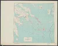
Description:
"Conical orthomorphic projection (Lambert conformal conic projection).", Elevations are shown by hachures and spot heights in meters., Inset shows area with detailed transportation information., and Principal roads, trails and railroads are shown.
Publisher:
Army Map Service,
Subject (Geographic):
Kyklades (Greece)--Maps
Subject (Topic):
Transportation--Greece--Kyklades--Maps
Found in:
Beinecke Rare Book and Manuscript Library > Cyclades [cartographic material] : special strategic map / compiled by the Army Map Service.
Creator:
Published / Created:
1943
Call Number:
4891gmb 1943
Container / Volume:
BRBL_00266
Image Count:
1
Resource Type:
Maps, Atlases & Globes
Alternative Title:
Its A.M.S. ; 6201 and Series (Standard map series designation system) ; 6201.
Description:
"Conical orthomorphic projection (Lambert conformal conic projection).", Elevations are shown by hachures and spot heights in meters., Inset shows area with detailed transportation information., and Principal roads, trails and railroads are shown.
Publisher:
Army Map Service,
Subject (Geographic):
Kyklades (Greece)--Maps
Subject (Topic):
Transportation--Greece--Kyklades--Maps
Found in:
Beinecke Rare Book and Manuscript Library > Cyclades [cartographic material] : special strategic map / compiled by the Army Map Service.
Creator:
Published / Created:
1943
Call Number:
509gm 1943
Container / Volume:
BRBL_00277
Image Count:
1
Resource Type:
Maps, Atlases & Globes
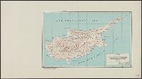
Description:
"6/43RM.", "Polyconic projection.", Elevations are shown by hachures and spot heights in feet., and Principal roads and railroads are shown.
Publisher:
Army Map Service,
Subject (Geographic):
Cyprus--Maps
Subject (Topic):
Transportation--Cyprus--Maps
Found in:
Beinecke Rare Book and Manuscript Library > Cyprus : special strategic map -- Asia / prepared under the direction of the chief of Engineers.
Creator:
Published / Created:
1947
Call Number:
509gm 1947
Container / Volume:
BRBL_00277
Image Count:
1
Resource Type:
Maps, Atlases & Globes
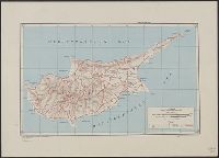
Description:
"11-47.", "5207.", "Polyconic projection.", Elevations are shown by hachures and spot heights in feet., Previous issue included in series AMS 6201., and Principal roads and railroads are shown.
Publisher:
Army Map Service,
Subject (Geographic):
Cyprus--Maps
Subject (Topic):
Transportation--Cyprus--Maps
Found in:
Beinecke Rare Book and Manuscript Library > Cyprus [cartographic material] : special strategic map -- Asia / prepared under the direction of the chief of Engineers.
Creator:
Published / Created:
1943
Call Number:
39 D41 1943
Container / Volume:
BRBL_00189
Image Count:
1
Resource Type:
Maps, Atlases & Globes
Alternative Title:
[Series] M981 and A.M.S. M981
Description:
"Copied from Spanish map 1:50,000, Gandia no. 796, 1938, revised in part.", At head of title: Spain 1:10,000., and Military grid.
Subject (Geographic):
Denia (Spain)--Maps
Found in:
Beinecke Rare Book and Manuscript Library > Denia [cartographic material] : city plan.
Branch:v1.61.6 ,Deployed:2024-06-12T09:55:33-04:00