
1.
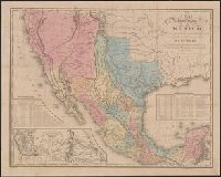
- Creator:
- Tanner, Henry Schenck, 1786-1858
- Published / Created:
- 1846
- Call Number:
- 88 1846C
- Container / Volume:
- BRBL_00645
- Image Count:
- 1
- Resource Type:
- Maps, Atlases & Globes
- Alternative Title:
- Map of the roads &c from Vera Cruz & Alvarado to Mexico., Tanner's travelling map of Mexico, and Travelling map of Mexico
- Description:
- "Entered according to act of Congress, in the year 1846, by H.S. Tanner in the clerks office of the district court for the southern district of New York.", Copy 2 without cover, mounted on linen., Includes distance and statistical tables and inset of "Map of the roads &c from Vera Cruz & Alvarado to Mexico" (scale [ca. 1:1,160,000])., Prime meridian: Washington., and Relief shown by hachures.
- Publisher:
- H.S. Tanner,
- Subject (Geographic):
- Mexico--Maps and Southwest, New--Maps
- Found in:
- Beinecke Rare Book and Manuscript Library > A map of the United States of Mexico : as organized and defined by the several acts of the Congress of that Republic / constructed from a great variety of printed and manuscript documents by H.S. Tanner.