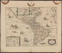
Appears in various eds. of Jan Jansson's Nouvel atlas., French text on verso., Includes ill. of ships and sea monsters, and insets showing "Polus Arcticus" region and "Terra Australis inc, and Sheet measures 50 x 59 cm. Stamp on verso: Yale, Horace Brown, 1900S.
Below title in cartouche: "Met privilegio voor 15 iaaren ao 1687.", Depths shown by soundings., Dutch and French., Inset map: Le partie du Carolina grand point., and Sheet measures 44.3 x 56.7 cm. Cross Collection no. 220.
Publisher:
s.n.],
Subject (Geographic):
Atlantic Coast (South Atlantic States)--Nautical charts--Early works to 1800 and South Carolina--Nautical charts--Early works to 1800
Subject (Topic):
Nautical charts--Atlantic Coast (South Atlantic States)--Early works to 1800 and Nautical charts--South Carolina--Early works to 1800
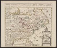
Insets: Les environs de Quebec -- Veüe de Quebec -- Les costes de la Louisiane., Relief shown pictorially., Same title appears in description of Chatelain's Atlas historique, 1732-39 ed., in Phillips' A list of geographical atlases ..., 579., and Yale's copy st
Publisher:
Châtelain?,
Subject (Geographic):
New France--Maps--Early works to 1800 and North America--Maps--Early works to 1800