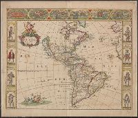
Includes decorative cartouche showi, Sheet measures 20.3 x 29.3 cm. Ms. no. in upper right corner: 61. Ms. no. in lower left corner: 18:29. Cross Collection no. 236., and Shows southern North America, Central America, northern South America and the West Indies.
Publisher:
s.n.,
Subject (Geographic):
Caribbean Area--Maps--Early works to 1800, Mexico, Gulf of--Maps--Early works to 1800, and West Indies--Maps--Early works to 1800
Subject (Topic):
Coasts--North America--Maps--Early works to 1800 and Coasts--South America--Maps--Early works to 1800
Appears in Jan Jansson's Atlas novus?, Cross Collection no. 310., Includes ill., index, and text., No text on verso., Pasted over map "Totius Hispaniae nova descriptio." Hand col., and Relief shown pictorially.
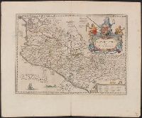
Dutch text of verso, with caption title "Nieuvv Spanien" and signature 2G., From Jansson's Nieuwen atlas ... Amstelodami : Apud Ioannem Ianssonium, 1647., Includes ill., index, and text., and Relief shown pictorially.
Includes ill., Library's copy stamped on backing: Yale University Library, Karpinski-Von Wieser Map Collection., Relief shown pictorially., and State 3, 1660, according to McLaughlin (date erased from cartouche and with "2" or "3" in top right). State 2, c. 1666
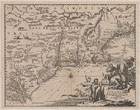
1st state. Cross collection no. 20. No. 3 of 3 maps mounted on linen., Appeared in Arnoldus Montanus's De Nieuwe en onbekende weereld., Includes ill., and Relief shown pictorially.
Publisher:
Jacob von Meurs?,
Subject (Geographic):
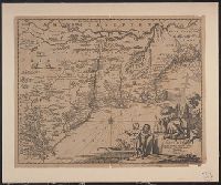
Middle Atlantic States--Maps--Early works to 1800 and New England--Maps--Early works to 1800
Subject (Name):
Montanus, Arnoldus, 1625?-1683. Nieuwe en onbekende weereld
Appeared in Arnoldus Montanus's De Nieuwe en onbekende weereld., Copy 2: 1st state. Uncolored. Mounted on linen. Dimensions: 29 x 37 cm., on sheet 36 x 44 cm. Verso: Stamped "Yale"., Includes ill., and Relief shown pictorially.
Publisher:
Jacob von Meurs?,
Subject (Geographic):
Middle Atlantic States--Maps--Early works to 1800 and New England--Maps--Early works to 1800
Subject (Name):
Montanus, Arnoldus, 1625?-1683. Nieuwe en onbekende weereld
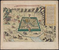
Has watermarks., Includes text and ill. of Noah's ark on Mount Ararat, angels, animals, Adam and Eve, and Cain slaying Abel., Oriented with north to the upper right., Perspective map., Relief shown pictorially., and Shows the Garden of Eden between the Tigris and
Publisher:
s.n.,
Subject (Topic):
Geographical myths--Maps--Early works to 1800, Noah's ark, and Paradise