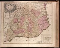
"Cum Privil.", Appeared in Peter Schenk's Atlas contractus., Backed with paper. Ms. no. "47" in lower-right corner. Sheet measures 62.5 x 53.7 cm. No. 44 of 87 maps bound together., Includes four bar scales., Prime meridian: Ferro., and Relief shown pictorially.
Publisher:
Peter Schenk],
Subject (Geographic):
Scotland--Maps--Early works to 1800.
Subject (Name):
Schenk, Peter, 1660-1718 or 1719. Atlas contractus.
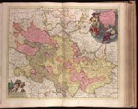
"Cum Privil. Ordin. Gen. Belg. Foed.", Appeared in Peter Schenk's Atlas contractus [ca. 1700]., Backed with paper. Ms. no. "33" in upper-right corner. Sheet measures 53.5 x 62.7 cm. No. 32 of 87 maps bound together., Bar scales given in "milliaria Germanica" and "milliaria Gallica"., Dedication: Sereniss. ac Potentissimo Dn. Dn. Iohanni Guilielmo Dg. Com. Palat. Rhen. S. R. I. Archithesaur. et Elect. Bavar. Iul. Cliv. ac Mont. Duc. etc. etc. Princ. ac Domino suo clementissimo hanc Palatinatus Rhen. Tabulam submisse dicat et consecrat., Prime meridian: Ferro., Relief shown pictorially., and Watermark.
Publisher:
Peter Schenk,
Subject (Geographic):
Baden-Württemberg (Germany)--Maps--Early works to 1800., Hesse (Germany)--Maps--Early works to 1800., and Rhineland-Palatinate (Germany)--Maps--Early works to 1800.
Subject (Name):
Schenk, Peter, 1660-1718 or 1719. Atlas contractus.
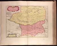
Petrocorivm comitatvs vulgo la comtée de Périgort
Description:
Backed with paper. Ms. no. "56" in upper-right corner. Sheet measures 53.8 x 63.4 cm. No. 51 of 87 maps bound together., Bar scales given in "lieues Francoises" and "milliaria Germanica communia"., Prime meridian: Ferro., Relief shown pictorially., and Watermark.
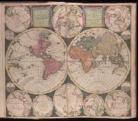
Vlakke aard-kloot gemeenlyk genaamd de geheele waereld
Description:
Backed with paper. Sheet measures 53.6 x 61.9 cm. No. 1 of 87 maps bound together., Includes twelve ancillary maps., Relief shown pictorially., Scale determined by using graticule method., and Watermark.
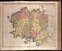
Appeared in Valk and Schenk's Atlantis sylloge compendiosa, ca. 1702., Backed with paper. Ms. no. "60" in upper right-hand corner. Sheet measures 53.6 x 62.8 cm. No. 55 of 87 maps bound together., Bar scales given in "milliaria Gallica" and "milliaria Germanica.", Prime meridian: Ferro., Relief shown pictorially., and Variation of Koeman, C. Atlantes Neerlandici, III, p. 138 (map 23); with addition of "Leo. Valk."
Publisher:
Gerard and Valk,
Subject (Geographic):
Brittany (France)--Maps--Early works to 1800.
Subject (Name):
Schenk, Peter, 1660-1718 or 1719. Atlantis sylloge compendiosa., Valck, G. (Gerard), 1651 or 1652-1726. Atlantis sylloge compendiosa., and Valck, Leonard, 1675-1746.
Appeared in Valk and Schenk's Atlantis sylloge compendiosa, ca. 1702., Backed with paper. Ms. no. "83" in upper right-hand corner. Sheet measures 53.5 x 62.0 cm. No. 77 of 87 maps bound together., Bar scales given in "milliaria Hungarica" and "milliaria Germanica.", Prime meridian: Ferro., and Relief shown pictorially.
Publisher:
Gerard and Leonard Valk,
Subject (Geographic):
Romania--Maps--Early works to 1800.
Subject (Name):
Schenk, Peter, 1660-1718 or 1719. Atlantis sylloge compendiosa. and Valck, G. (Gerard), 1651 or 1652-1726. Atlantis sylloge compendiosa.
Appears in Valk and Schenk's Atlantis sylloge compendiosa, ca. 1702., Backed with paper. Ms. no. "64" in upper right corner. Sheet measures 53.7 x 62.1 cm. No. 59 of 87 maps bound together., Includes 5 bar scales., Prime meridian: Ferro., Relief shown pictorially., and Watermark.
Publisher:
Gerard Valck,
Subject (Geographic):
Catalonia (Spain)--Maps--Early works to 1800.
Subject (Name):
Schenk, Peter, 1660-1718 or 1719. Atlantis sylloge compendiosa., Valck, G. (Gerard), 1651 or 1652-1726. Atlantis sylloge compendiosa., and Valck, Leonard, 1675-1746.
"C. privi.", Appeared in Peter Schenk's Atlas contractus [ca. 1700]., Backed with paper. Ms. no. "38" in upper-right corner. Sheet measures 53.7 x 62.4 cm. No. 37 of 87 maps bound together., Bar scales given in "milliaria Germanica," "milliaria Francica," and "milliaria geometrica sive Italica"., Prime meridian: Ferro., Relief shown pictorially., and Watermark.
Publisher:
Peter Schenk],
Subject (Geographic):
Benelux countries--Maps--Early works to 1800.
Subject (Name):
Schenk, Peter, 1660-1718 or 1719. Atlas contractus.
Backed with paper. Ms. no. "67" in upper-right corner. Sheet measures 53.7 x 62.3 cm. No. 62 of 87 maps bound together., Bar scales given in "milliaria Italica" and "milliaria Germanica.", and Prime meridian: Ferro.
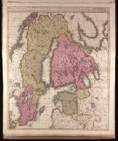
Appeard in Gerard Valck and Peter Schenk's Atlantis sylloge, ca. 1702., Backed with paper. Ms. no. "5" in upper left-hand corner. Sheet measures 62.8 x 53.4 cm. No. 4 of 87 maps bound together., Bar scales given in "milliaria Germanica" and "milliaria Suecia sive Danica"., Prime meridian: Ferro., and Relief shown pictorially.
Publisher:
Gerard Valck,
Subject (Geographic):
Baltic States--Maps--Early works to 1800. and Scandinavia--Maps--Early works to 1800.
Subject (Name):
Schenk, Peter, 1660-1718 or 1719. Atlantis sylloge compendiosa. and Valck, G. (Gerard), 1651 or 1652-1726.. Atlantis sylloge compendiosa.