Search
You Searched For
Search Results
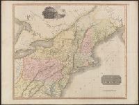
- Published / Created:
- 1817
- Call Number:
- 755 1817
- Container / Volume:
- BRBL_00439
- Image Count:
- 1
- Resource Type:
- Maps, Atlases & Globes
- Found in:
- Beinecke Rare Book and Manuscript Library > Northern Provinces of the United States. Hewitt Sc., London.
- Published / Created:
- 1817
- Call Number:
- 755 1817
- Container / Volume:
- BRBL_00439
- Image Count:
- 1
- Resource Type:
- Maps, Atlases & Globes
- Found in:
- Beinecke Rare Book and Manuscript Library > Northern Provinces of the United States. Hewitt Sc., London.
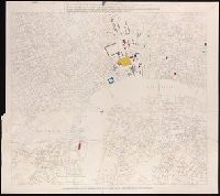
- Published / Created:
- [between 1860 and 1869?]
- Call Number:
- BrSides Double Folio 2019 87
- Image Count:
- 1
- Resource Type:
- Maps, Atlases & Globes
- Found in:
- Beinecke Rare Book and Manuscript Library > Map of London showing the present and future sites of law courts and offices.
- Creator:
- Royal Geographical Society (Great Britain)
- Published / Created:
- 1911
- Call Number:
- 26912 1911
- Container / Volume:
- BRBL_00023A
- Image Count:
- 1
- Resource Type:
- Maps, Atlases & Globes
- Found in:
- Beinecke Rare Book and Manuscript Library > New Guinea, central Papua, route and explorations of the expedition of D. Mackay and W.S. Little, 1908-9.
- Creator:
- Royal Geographical Society (Great Britain)
- Published / Created:
- 1908
- Call Number:
- 26912 1908A
- Container / Volume:
- BRBL_00023A
- Image Count:
- 1
- Resource Type:
- Maps, Atlases & Globes
- Found in:
- Beinecke Rare Book and Manuscript Library > Part of British New Guinea.
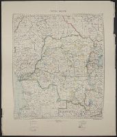
- Creator:
- Great Britain. War Office. General Staff. Geographical Section
- Published / Created:
- 1921
- Call Number:
- 652 1921
- Container / Volume:
- BRBL_00342
- Image Count:
- 1
- Resource Type:
- Maps, Atlases & Globes
- Found in:
- Beinecke Rare Book and Manuscript Library > Congo Belge.
- Creator:
- Great Britain. War Office. General Staff. Geographical Section
- Published / Created:
- 1909
- Call Number:
- BrSides Double Folio 2018 95
- Image Count:
- 1
- Resource Type:
- Maps, Atlases & Globes
- Found in:
- Beinecke Rare Book and Manuscript Library > Cable map of the world [cartographic material].
- Published / Created:
- 1817
- Call Number:
- 755 1817
- Container / Volume:
- BRBL_00439
- Image Count:
- 1
- Resource Type:
- Maps, Atlases & Globes
- Found in:
- Beinecke Rare Book and Manuscript Library > Northern Provinces of the United States. Hewitt Sc., London.
- Creator:
- Canning, Alfred Wernam, 1860-1936
- Published / Created:
- 1911
- Call Number:
- 2651 W713 1911
- Container / Volume:
- BRBL_00023
- Image Count:
- 1
- Resource Type:
- Maps, Atlases & Globes
- Found in:
- Beinecke Rare Book and Manuscript Library > The Wiluna-Kimberley stock route [cartographic material] / by A.W. Canning.
- Published / Created:
- 1916
- Call Number:
- 304ed 1916
- Container / Volume:
- BRBL_00034A
- Image Count:
- 1
- Resource Type:
- Maps, Atlases & Globes
- Found in:
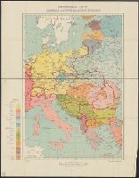
- Beinecke Rare Book and Manuscript Library > Ethnographical Map of Central & South Eastern Europe.
- Published / Created:
- [1910?]
- Call Number:
- 344 1910
- Container / Volume:
- BRBL_00093
- Image Count:
- 1
- Resource Type:
- Maps, Atlases & Globes
- Found in:
- Beinecke Rare Book and Manuscript Library > Norway.
- Creator:
- Phillips, R. (Richard), Sir, 1767-1840
- Published / Created:
- [1806]
- Call Number:
- BrSides Folio 2017 61
- Image Count:
- 1
- Resource Type:
- Maps, Atlases & Globes
- Found in:
- Beinecke Rare Book and Manuscript Library > A map of the country from Rariton River in East Jersey, to Elk Head in Maryland [cartographic material] : shewing the several operations of the American & British armies, in 1776 & 1777 / Neele sc., Strand.
- Published / Created:
- 1931
- Call Number:
- 11hc 1918E
- Container / Volume:
- BRBL_00010E
- Image Count:
- 2
- Resource Type:
- Maps, Atlases & Globes
- Found in:
- Beinecke Rare Book and Manuscript Library > Earl Haig's war map refutes General Pershing.
- Published / Created:
- 1918
- Call Number:
- 11hc 1918D
- Container / Volume:
- BRBL_00010E
- Image Count:
- 2
- Resource Type:
- Maps, Atlases & Globes
- Found in:
- Beinecke Rare Book and Manuscript Library > Three Months of Victory on the Western Front.
- Published / Created:
- 1918
- Call Number:
- 11hc 1918D-2
- Container / Volume:
- BRBL_00010E
- Image Count:
- 2
- Resource Type:
- Maps, Atlases & Globes
- Found in:
- Beinecke Rare Book and Manuscript Library > The Position of the Western Front.
- Creator:
- Des Barres, Joseph F. W. (Joseph Frederick Wallet), 1722-1824
- Published / Created:
- Aug. 1 1781.
- Call Number:
- 734cea G214 1781
- Container / Volume:
- BRBL_00380
- Image Count:
- 2
- Resource Type:
- Maps, Atlases & Globes
- Found in:
- Beinecke Rare Book and Manuscript Library > [A chart of the Bay of Gaspey &c. / surveyed by Samuel Holland].
- Published / Created:
- 1766
- Call Number:
- 786gmg P838 1766
- Container / Volume:
- BRBL_00516
- Image Count:
- 1
- Resource Type:
- Maps, Atlases & Globes
- Found in:
- Beinecke Rare Book and Manuscript Library > A draught of Port Royal Harbour in South Carolina with the marks for going in. By JAmes Cook.
- Creator:
- Great Britain. War Office. General Staff. Geographical Section
- Published / Created:
- [1918?]
- Call Number:
- 36 K54 1918
- Container / Volume:
- BRBL_00124
- Image Count:
- 1
- Resource Type:
- Maps, Atlases & Globes
- Found in:
- Beinecke Rare Book and Manuscript Library > Kiel Canal and Heligoland.
- Creator:
- Royal Geographical Society (Great Britain)
- Published / Created:
- 1921
- Call Number:
- 53 1921
- Container / Volume:
- BRBL_00285
- Image Count:
- 1
- Resource Type:
- Maps, Atlases & Globes
- Found in:
- Beinecke Rare Book and Manuscript Library > Map of eastern Turkey in Asia, Syria and western Persia [cartographic material].
- Creator:
- Great Britain. War Office. General Staff. Geographical Section
- Published / Created:
- 1905
- Call Number:
- 4894 1905A
- Container / Volume:
- BRBL_00267
- Image Count:
- 1
- Resource Type:
- Maps, Atlases & Globes
- Found in:
- Beinecke Rare Book and Manuscript Library > Map of Crete [cartographic material].
- Published / Created:
- [1750?]
- Call Number:
- 615 32
- Container / Volume:
- BRBL_00332
- Image Count:
- 2
- Resource Type:
- Maps, Atlases & Globes
- Found in:
- Beinecke Rare Book and Manuscript Library > Aegyptus et Cyrenaica.
- Published / Created:
- 1776
- Call Number:
- 32 1776
- Container / Volume:
- BRBL_00044
- Image Count:
- 2
- Resource Type:
- Maps, Atlases & Globes
- Found in:
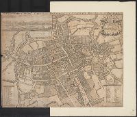
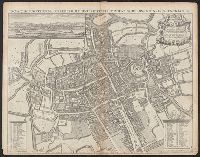
- Beinecke Rare Book and Manuscript Library > A new travelling map of the country round London ...
- Published / Created:
- 1719
- Call Number:
- 11 1719A
- Container / Volume:
- BRBL_00004
- Image Count:
- 1
- Resource Type:
- Maps, Atlases & Globes
- Found in:
- Beinecke Rare Book and Manuscript Library > A new and correct map of the whole world ... / by Herman Moll ...
- Published / Created:
- 1719
- Call Number:
- 11 1719B
- Container / Volume:
- BRBL_00004
- Image Count:
- 1
- Resource Type:
- Maps, Atlases & Globes
- Found in:
- Beinecke Rare Book and Manuscript Library > A new and correct map of the whole world ... / by Herman Moll ...
- Published / Created:
- 1755
- Call Number:
- 21 1755
- Container / Volume:
- BRBL_00014
- Image Count:
- 1
- Resource Type:
- Maps, Atlases & Globes
- Found in:
- Beinecke Rare Book and Manuscript Library > A New Chart of the Vast Atlantic Ocean; Exhibiting the Seat of War, both in Europe and America ...
- Published / Created:
- 1855
- Call Number:
- 26cea 1843B
- Container / Volume:
- BRBL_00023
- Image Count:
- 1
- Resource Type:
- Maps, Atlases & Globes
- Found in:
- Beinecke Rare Book and Manuscript Library > Australia, East Coast Sheet XIX. Cape Flattery to Cape Sidmouth and the Barrier Reefs, surveyed by Capt. F. Blackwood, C.B. Yule, Mr. F.I. Evans; Master, Mr. D. Aird, Mate H.M.S. Fly, and Capt. Owen Stanley, Lieuts. C.B. Yule, J. Dayman, H.G. Simpson and
- Published / Created:
- 1916
- Call Number:
- 11hcf 1919B-3
- Container / Volume:
- BRBL_00010Q
- Image Count:
- 1
- Resource Type:
- Maps, Atlases & Globes
- Found in:
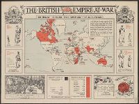
- Beinecke Rare Book and Manuscript Library > The British Empire at War : the men of the empire; their homes and their battlefields.
- Published / Created:
- 1814
- Call Number:
- 26cea 1799
- Container / Volume:
- BRBL_00023
- Image Count:
- 1
- Resource Type:
- Maps, Atlases & Globes
- Found in:
- Beinecke Rare Book and Manuscript Library > Chart of Terra Australis by M. Flinders, Commr. of H.M. Sloop Investigator 1799-1803. East Coast sheet III ...
- Creator:
- Geological Survey (U.S.)
- Published / Created:
- 1916
- Call Number:
- 304ed 1916
- Container / Volume:
- BRBL_00034A
- Image Count:
- 1
- Resource Type:
- Maps, Atlases & Globes
- Found in:
- Beinecke Rare Book and Manuscript Library > Ethnographical Map of Central & South Eastern Europe.
- Creator:
- Compton, Henry, 1632-1713, dedicatee
Loggan, David, 1635-1700?
Loggan, David, 1635-1700? Oxonia illustrata, 1714
Overton, Henry, 1675 or 6-1751, publisher
- Published / Created:
- 1675 [i.e., 1714?]
- Call Number:
- 32 Ox1 1675A
- Container / Volume:
- BRBL_00052A
- Image Count:
- 1
- Resource Type:
- Maps, Atlases & Globes
- Found in:
- Beinecke Rare Book and Manuscript Library > Nova et accuratissima celeberrimæ universitatis civitatisque Oxoniensis scenographia / Dav. Loggan delin. et sculp.
- Published / Created:
- [1845?]
- Call Number:
- 32 L84 1845
- Container / Volume:
- BRBL_00050
- Image Count:
- 1
- Resource Type:
- Maps, Atlases & Globes
- Found in:
- Beinecke Rare Book and Manuscript Library > Payne's Illustrated Plan of London.
- Creator:
- Compton, Henry, 1632-1713, dedicatee
Loggan, David, 1635-1700?
Loggan, David, 1635-1700? Oxonia illustrata, 1714
Overton, Henry, 1675 or 6-1751, publisher
- Published / Created:
- 1675 [i.e., 1714?]
- Call Number:
- 32 Ox1 1675A
- Container / Volume:
- BRBL_00052A
- Image Count:
- 1
- Resource Type:
- Maps, Atlases & Globes
- Found in:
- Beinecke Rare Book and Manuscript Library > Nova et accuratissima celeberrimæ universitatis civitatisque Oxoniensis scenographia / Dav. Loggan delin. et sculp.
- Creator:
- Great Britain. War Office. General Staff. Geographical Section
- Published / Created:
- 1919
- Call Number:
- 399 1919
- Container / Volume:
- BRBL_00195
- Image Count:
- 1
- Resource Type:
- Maps, Atlases & Globes
- Found in:
- Beinecke Rare Book and Manuscript Library > Straits of Gibraltar [cartographic material].
- Creator:
- Neele, Samuel John, 1758-1824
- Published / Created:
- 1790
- Call Number:
- 400 1790
- Container / Volume:
- BRBL_00233
- Image Count:
- 1
- Resource Type:
- Maps, Atlases & Globes
- Found in:
- Beinecke Rare Book and Manuscript Library > The northern part of ancient Italy / engrav'd by Samuel John Neele.
- Published / Created:
- 1943
- Call Number:
- 507 N159 1943
- Container / Volume:
- BRBL_00277
- Image Count:
- 1
- Resource Type:
- Maps, Atlases & Globes
- Found in:
- Beinecke Rare Book and Manuscript Library > South Levant 1:50,000. Naoua.
- Creator:
- Royal Geographical Society (Great Britain)
- Published / Created:
- [1915?]
- Call Number:
- 53 1915
- Container / Volume:
- BRBL_00285
- Image Count:
- 1
- Resource Type:
- Maps, Atlases & Globes
- Found in:
- Beinecke Rare Book and Manuscript Library > Map of eastern Turkey in Asia, Syria and western Persia [cartographic material].
- Creator:
- Great Britain. War Office. General Staff. Geographical Section
- Published / Created:
- 1945
- Call Number:
- 5855 1945
- Container / Volume:
- BRBL_00315
- Image Count:
- 1
- Resource Type:
- Maps, Atlases & Globes
- Found in:
- Beinecke Rare Book and Manuscript Library > Malaya 1:380,160 : Kota Bharu Sheet No.2.
- Creator:
- Great Britain. Directorate of Colonial Surveys
- Published / Created:
- 1954
- Call Number:
- 63 1954 Sheet 3
- Container / Volume:
- BRBL_00335
- Image Count:
- 1
- Resource Type:
- Maps, Atlases & Globes
- Found in:
- Beinecke Rare Book and Manuscript Library > East Africa. Population, tsetse fly and rainfall [cartographic material] / drawn by Directorate of Colonial Surveys from information supplied by the Royal Commision to East Africa.
- Creator:
- Great Britain. Directorate of Colonial Surveys
- Published / Created:
- 1954
- Call Number:
- 63 1954 Sheet 1
- Container / Volume:
- BRBL_00335
- Image Count:
- 1
- Resource Type:
- Maps, Atlases & Globes
- Found in:
- Beinecke Rare Book and Manuscript Library > East Africa. General [cartographic material] / drawn by Directorate of Colonial Surveys from information supplied by the Royal Commision to East Africa.
- Creator:
- Great Britain. War Office. General Staff. Geographical Section
- Published / Created:
- 1910
- Call Number:
- 631 1910
- Container / Volume:
- BRBL_00335
- Image Count:
- 1
- Resource Type:
- Maps, Atlases & Globes
- Found in:
- Beinecke Rare Book and Manuscript Library > Africa 1:1 000 000. Lake Victoria [cartographic material] / drawn at the War Office ; engraved by W. & A.K. Johnson, Limited.
- Creator:
- Great Britain. Directorate of Colonial Surveys
- Published / Created:
- 1954
- Call Number:
- 63 1954 Sheet 4
- Container / Volume:
- BRBL_00335
- Image Count:
- 1
- Resource Type:
- Maps, Atlases & Globes
- Found in:
- Beinecke Rare Book and Manuscript Library > Kenya. Boundaries, land units, population, tsetse fly and rainfall [cartographic material] / drawn by Directorate of Colonial Surveys from information supplied by the Royal Commision to East Africa.
- Creator:
- Great Britain. Directorate of Colonial Surveys
- Published / Created:
- 1954
- Call Number:
- 63 1954 Sheet 2
- Container / Volume:
- BRBL_00335
- Image Count:
- 1
- Resource Type:
- Maps, Atlases & Globes
- Found in:
- Beinecke Rare Book and Manuscript Library > East Africa. Population, tsetse fly and rainfall [cartographic material] / drawn by Directorate of Colonial Surveys from information supplied by the Royal Commision to East Africa.
- Creator:
- Great Britain. War Office. General Staff. Geographical Section
- Published / Created:
- 1921
- Call Number:
- 652 1921
- Container / Volume:
- BRBL_00342
- Image Count:
- 1
- Resource Type:
- Maps, Atlases & Globes
- Found in:
- Beinecke Rare Book and Manuscript Library > Congo Belge.
- Creator:
- Royal Geographical Society (Great Britain)
- Published / Created:
- 1911
- Call Number:
- 652 Ar86 1911A
- Container / Volume:
- BRBL_00343
- Image Count:
- 1
- Resource Type:
- Maps, Atlases & Globes
- Found in:
- Beinecke Rare Book and Manuscript Library > Belgian Congo. Chart of the River Aruwimi : from a survey by Robt. L. Reid, 1908-10.
- Creator:
- Great Britain. War Office. General Staff. Geographical Section
- Published / Created:
- 1910
- Call Number:
- 6551 1910
- Container / Volume:
- BRBL_00346
- Image Count:
- 1
- Resource Type:
- Maps, Atlases & Globes
- Found in:
- Beinecke Rare Book and Manuscript Library > Northern and southern Nigeria / Comp. in the Geog. Section, Gen. Staff.
- Creator:
- Great Britain. War Office. General Staff. Topographical Section
- Published / Created:
- 1905
- Call Number:
- 658 1905
- Container / Volume:
- BRBL_00346
- Image Count:
- 1
- Resource Type:
- Maps, Atlases & Globes
- Found in:
- Beinecke Rare Book and Manuscript Library > Africa 1:1,000,000. Liberia.
- Creator:
- Thornton, John, fl. 1652-1701
- Published / Created:
- [ca. 1673?]
- Call Number:
- 71 1673
- Container / Volume:
- BRBL_00360
- Image Count:
- 1
- Resource Type:
- Maps, Atlases & Globes
- Found in:
- Beinecke Rare Book and Manuscript Library > A new mapp of the north part of America : from Hudson Straights commanly call'd the Norwest Passage, including Newfoundland, New Scotland, New England, Virginia, Maryland & Carolena / made and sold by John Thornton at the signe of England, Scotland & Irel
- Creator:
- Des Barres, Joseph F. W. (Joseph Frederick Wallet), 1722-1824
- Published / Created:
- Sept. 1 1781.
- Call Number:
- 733cea R49 1781
- Container / Volume:
- BRBL_00379
- Image Count:
- 1
- Resource Type:
- Maps, Atlases & Globes
- Found in:
- Beinecke Rare Book and Manuscript Library > The harbours of Rishibucto & Buctush on the west shore of the Gulph of St. Lawrence.
- Creator:
- Des Barres, Joseph F. W. (Joseph Frederick Wallet), 1722-1824
- Published / Created:
- Aug. 1 1781.
- Call Number:
- 734cea C35 1781
- Container / Volume:
- BRBL_00380
- Image Count:
- 1
- Resource Type:
- Maps, Atlases & Globes
- Found in:
- Beinecke Rare Book and Manuscript Library > [A chart of Chaleurs Bay / surveyed by Samuel Holland].