Ferro meridian., No. 38 of 43 maps bound together in composite atlas., Relief shown by hachures., Scale [1:1,750,000]., and Shows rivers and settlements.
Subject (Geographic):
Egypt --Maps --Early works to 1800 and Nile River --Maps --Early works to 1800
British & Spanish territories according to the treaty of 1784
Description:
For a description of the second and third states see Stevens and Tree, Comparative Cartography, Map Collectors' Circle (1967)., Includes historical notes and a color key., Includes text., No. 40 of 43 maps bound together in composite atlas., Prime meridian: London., Relief shown pictorially., Scale [ca. 1:6,750,000]., and Shows numerous boundary changes.
Publisher:
Willm. Faden
Subject (Geographic):
United States --Boundaries --Maps --Early works to 1800 and United States --Maps --Early works to 1800
Allan, A., Capt Beatson, Alexander, 1759-1833 Harmar, Thomas Rennell, James, 1742-1830, creator
Published / Created:
1792 February 21
Call Number:
1982 Folio 10
Image Count:
1
Description:
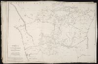
Compiled from the original maps, drawn by Capt. A. Beatson and Capt. A. Allan ; with some particulars added in explanation by J. Rennell ; plan work by I. Walker ; writing by T. Harmar., Map with relief shown pictorially., No. 33 of 43 maps bound together in composite atlas., and Scale [ca. 1:750,000].
Publisher:
J. Rennell
Subject (Geographic):
India, South --History, Military --Maps --Early works to 1800