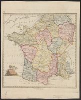
From the Atlantic Neptune, Vol.3, ,,, the coast and harbours of New England ... From the surveys ... by Samuel Holland, Esq. Part II. Plate "9". and Stipple engraved sailing chart, land col. pale brown by hand, modified for individual holdings, cities red. Hi
Des Barres, Joseph F. W. (Joseph Frederick Wallet), 1722-1824
Published / Created:
Augt. 1st, 1781.
Call Number:
734 S46 1781
Container / Volume:
BRBL_00380
Image Count:
1
Resource Type:
Maps, Atlases & Globes
Description:
Appears in the author's Atlantic neptune., Has watermark., Oriented with north to the right., Relief shown by hachures and shading. Depths shown by soundings., and Title supplied by cataloger.
Publisher:
J.F.W. Des Barres,
Subject (Geographic):
Sept-Iles (Québec)--Maps--Early works to 1800 and Seven Islands Bay (Québec)--Maps--Early works to 1800
Subject (Name):
Des Barres, Joseph F. W. (Joseph Frederick Wallet), 1722-1824. Atlantic neptune
Subject (Topic):
Harbors--Québec--Sept-Iles--Maps--Early works to 1800
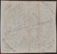
The earth's eastern planisphere., The earth's western planisphere., The eastern planisphere of the heavens., and The western planisphere of the heavens.
Description:
2 astronomical charts, 2 hemispherical maps, 1 untitled slider sheet. and Imperfect: Sheet 5 trimmed, with some loss of text.
Publisher:
Published ... by S. Dunn & W. Owen,
Subject (Geographic):
Eastern Hemisphere--Maps--Early works to 1800 and Western Hemisphere--Maps--Early works to 1800
Subject (Name):
Dunn, Samuel, d. 1794, publisher
Subject (Topic):
Constellations--Charts, diagrams, etc.--Early works to 1800