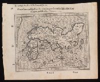
I haue heere added for the readers profit and delight this map of Iapan, published by I. Hondivs, I have heere added for the readers profit and delight this map of Iapan, published by I. Hondius, and Japan I.
Description:
Relief shown pictorially., Removed from Samuel Purchas's Purchas his Pilgrimage (1625)., and Text in English on verso with signature 3M3 at foot of map.
Publisher:
[Printed by William Stansby for Henrie Fetherstone],
Subject (Geographic):
Japan--Maps--Early works to 1800.
Subject (Name):
Featherstone, Henry, -1647, bookseller., Purchas, Samuel, 1577?-1626. Purchas his Pilgrimage. 1625., and Stansby, William, active 1597-1638, printer.
"Plate XXXVI" in upper right corner., Bar scale given in "British statute miles.", Coordinates not present on map and are approximated., and North oriented towards bottom of map.
Publisher:
Published Jany 1st, 1803, by Cadell & Davies, Strand,
Appeared in Thomas Stackhouse's Universal atlas., Imperfect: right edge of map trimmed, with some loss of text. Backed with linen., Prime meridians: London and Ferro., and Relief shown pictorially.
Publisher:
Publish'd by T. Stackhouse,
Subject (Geographic):
Belarus--Maps--Early works to 1800., Lithuania--Maps--Early works to 1800., Poland--Maps--Early works to 1800., Prussia (Germany)--Maps--Early works to 1800., and Ukraine--Maps--Early works to 1800.
"Humbly dedicated to Elihu Yale, esq., of Place Grove in Denbyshire by his obliged humble servants, Cha. Price, Ion. Senex, Ion. Maxwell, Geographers to the Queen.", Imperfect: chipped along edges, with some loss of text. Mounted on cardboard., and Relief shown pictorially.
Publisher:
[John Senex],
Subject (Geographic):
Netherlands--Maps--Early works to 1800.
Subject (Name):
Maxwell, John, active 1708-1712, dedicator., Price, Charles, active 1700-1707, dedicator., and Yale, Elihu, 1649-1721, dedicatee.
Engravers: Emanuel Bowen, C. Moore, and G. Child., From Jean-Baptiste Du Halde's Description géographique, historique, chronologique, politique, et physique de l'empire de la Chine (English edition, 1738)., From maps originally drawn in 1709-1710 by Jean Baptiste, Pierre Jartoux, Xavier Ehrenbert Fridelli, and Guillaume Bonjour., Prime meridians: Paris and Peking [Beijing]., Relief shown pictorially., and Watermarks.
Publisher:
[T. Gardner for Edward Cave],
Subject (Geographic):
Asia, Central--Maps--Early works to 1800.
Subject (Name):
Bonjour, Guillaume, 1670-1714, cartographer., Bowen, Emanuel, 1693 or 1694-1767, engraver., Child, G., engraver., and Du Halde, J.-B. (Jean-Baptiste), 1674-1743. Description géographique, historique, chronologique, politique,