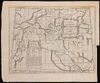
"Longitude taken from the Iron Island.", From "An Universal History, from the Earliest Account of Time" (1747)., In upper right corner, "Vol. 1, facing page 1.", Relief shown pictorially., and Watermark.
Publisher:
[Thomas Osborne],
Subject (Geographic):
Middle East--Historical geography--Maps--Early works to 1800.
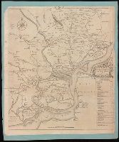
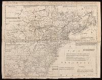
Coordinates not present on map and are approximated., From Gentleman's Magazine, vol. 23, 1753 p. 373., Includes table of distances "The distances of particular places in this map, from the court house.", and Manuscript "(G)" at top of sheet. Mounted on blue paper.
Publisher:
[publisher not identified],
Subject (Geographic):
Philadelphia (Pa.)--Maps--Early works to 1800. and Philadelphia Region--Maps--Early works to 1800.
Subject (Name):
Heap, George, active 1715-1760
Subject (Topic):
Landowners--Pennsylvania Region--Philadelphia--Maps--Early works to 1800. and Landowners--Pennsylvania--Philadelphia--Maps--Early works to 1800.
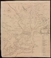
Coordinates not present on map and are approximated., From Gentleman's Magazine, vol. 23, 1753 p. 373., Includes table of distances "The distances of particular places in this map, from the court house.", and Manuscript annotation at bottom [partially trimmed].
Publisher:
[publisher not identified],
Subject (Geographic):
Philadelphia (Pa.)--Maps--Early works to 1800. and Philadelphia Region--Maps--Early works to 1800.
Subject (Name):
Heap, George, active 1715-1760
Subject (Topic):
Landowners--Pennsylvania Region--Philadelphia--Maps--Early works to 1800. and Landowners--Pennsylvania--Philadelphia--Maps--Early works to 1800.
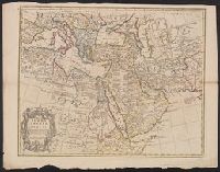
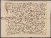
Map of Turkey, Arabia & Persia and Map of Turkey, Arabia and Persia
Description:
Appears in Senex's A new general atlas ... London: Printed for Daniel Browne ... [etc.], 1721., Relief shown pictorially., and Sheet measures 53 x 69 cm. Cross Collection no. 104.
Publisher:
Sold by John Senex at the Globe against St. Dunstans Church Fleetstreet,
Subject (Geographic):
Africa--Maps--Early works to 1800, Arabian Peninsula--Maps--Early works to 1800, Iran--Maps--Early works to 1800, and Middle East--Maps--Early works to 1800
Dated from other maps in the atlas., Decorative title cartouche., From Senex's A new general atlas ... London: Printed for Daniel Browne ... [etc.], 1721., Hand col. Mounted on linen. Sheet measures 50 x 67 cm. Cross Collection no. 93., London meridian., Relief shown pictorially., and Shows boundaries, rivers, roads, and settlements.
Publisher:
Sold by John Senex ...,
Subject (Geographic):
Castile (Spain)--Early works to 1800--Maps
Subject (Name):
Méndez Silva, Rodrigo, 1607-1675, Senex, John, d. 1740, and Senex, John, d. 1740. New general atlas
From General magazine of arts and sciences (London, England : 1755), Prime meridian: London., pt. the first. Containing Canada, Nova scotia, Newfoundland, New England, part of New York, with the Lakes, Six Nations, and all the countries westward in the same parallels so far as discover'd; exhibiting the just boundaries, and the French encroachments: laid down from authentic surveys -- pt. the second. Containing part of New York, Pensilvania, New Jersey, Mary Land, Virginia, North & South Carolina, Georgia, Louisiana, and all the countries westward in the same parellels so far as discovered, shewing the course of the Rivers Ohio, Missisipi &c. exhibiting the just boundaries & the French encroachments laid down from authentic surveys., Relief shown pictorially., Sheets pasted together to form one sheet. Watermark., and Shows boundaries, rivers, forests, principal settlements and notes.
Publisher:
[publisher not identified],
Subject (Geographic):
France--Colonies--America--Maps--Early works to 1800., Great Britain--Colonies--America--Maps--Early works to 1800., and North America--Maps--Early works to 1800.
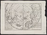
"Vol. I. p. 805" in upper left corner., Appears in: Atlas minor, or, A new and curious set of sixty-two maps. [London] : Printed for Tho: Bowles next ye Chapter House in St. Pauls Church Yard, & John Bowles at the Black Horse in Cornhill ..., [1736?], Cross collection no. 53., From: Thomas Salmon's Modern history. London : Printed for Messrs. Bettesworth and Hitch, J. Clarke, S. Birt, Tho. Wotton, and J. Shuckburgh, and T. Osborne, 1739., Includes text., and Relief shown pictorially.
Publisher:
Printed for Tho. Bowles next the Chapter house in St. Pauls church yard & Iohn Bowles at the Black Horse in Cornhill,
Subject (Geographic):
Arctic Regions--Maps--Early works to 1800 and North Pole--Maps--Early works to 1800
Subject (Name):
Bowles, John, 1701-1779, bookseller, Bowles, Thomas, -1767, bookseller, and Salmon, Thomas, 1679-1767. Modern history
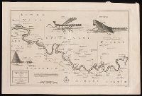
"No. 58" at bottom left; "Plate XLII. Vol. 2 page 159" at bottom right., Coordinates not present on map and are approximated., Relief shown pictorially and by soundings., Shows topography, waterways, routes, settlements., and Watermark.
Publisher:
[publisher not identified],
Subject (Geographic):
Gambia River--Maps--Early works to 1800. and Gambia--Maps--Early works to 1800.