Search
You Searched For
Search Results
- Creator:
- Kitchin, Thomas, d. 1784
- Published / Created:
- [1782]
- Call Number:
- 755 1760A
- Container / Volume:
- BRBL_00428
- Image Count:
- 1
- Resource Type:
- Maps, Atlases & Globes
- Found in:
- Beinecke Rare Book and Manuscript Library > A new map of the British Empire in Nth. America / drawn from the latest authorities by Thos. Kitchin, geor., hydrographer to His Majesty.
- Creator:
- Moll, Herman, -1732
- Published / Created:
- 1720
- Call Number:
- 71 1720C
- Container / Volume:
- BRBL_00687
- Image Count:
- 1
- Resource Type:
- Maps, Atlases & Globes
- Found in:
- Beinecke Rare Book and Manuscript Library > A new map of the north parts of America claimed by France under ye names of Louisiana, Mississipi, Canada and New France with ye adjoyning territories of England and Spain ... : the projection of this map is call'd Mercator's, and it is laid down accordin
- Creator:
- Moll, Herman, -1732
- Published / Created:
- 1720
- Call Number:
- 71 1720C
- Container / Volume:
- BRBL_00361
- Image Count:
- 1
- Resource Type:
- Maps, Atlases & Globes
- Found in:
- Beinecke Rare Book and Manuscript Library > A new map of the north parts of America claimed by France under ye names of Louisiana, Mississipi, Canada and New France with ye adjoyning territories of England and Spain ... : the projection of this map is call'd Mercator's, and it is laid down accordin
- Creator:
- Armstrong, John, d. 1758
- Published / Created:
- 1756
- Call Number:
- 3969 SA25 1756
- Container / Volume:
- BRBL_00194
- Image Count:
- 1
- Resource Type:
- Maps, Atlases & Globes
- Found in:
- Beinecke Rare Book and Manuscript Library > A plan of St. Philips Castle on the island of Minorca : with its fortifications & the entrance of the harbour of Port Mahon / by Jno. Armstrong, Surveyor General to the Honble. Board of Ordnance.
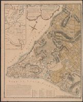
- Published / Created:
- 1766
- Call Number:
- 771 N49 1766
- Container / Volume:
- BRBL_00484
- Image Count:
- 1
- Resource Type:
- Maps, Atlases & Globes
- Found in:
- Beinecke Rare Book and Manuscript Library > A plan of the City of New York and its environs ... John Montresor Engineer.
- Published / Created:
- 1766
- Call Number:
- 771 N49 1766
- Container / Volume:
- BRBL_00484
- Image Count:
- 1
- Resource Type:
- Maps, Atlases & Globes
- Found in:
- Beinecke Rare Book and Manuscript Library > A plan of the City of New York and its environs ... John Montresor Engineer.
- Creator:
- Jefferys, Thomas, d. 1771
- Published / Created:
- 1758
- Call Number:
- 7325 L93 1758
- Container / Volume:
- BRBL_00377
- Image Count:
- 1
- Resource Type:
- Maps, Atlases & Globes
- Found in:
- Beinecke Rare Book and Manuscript Library > A plan of the city and fortifications of Louisburg / from a survey made by Richard Gridley, Lieut. Coll. of the Train of Artillery in 1745.
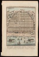
- Creator:
- Harris, John, 1667?-1719.
- Published / Created:
- [1744]
- Call Number:
- BrSides Folio 2017 33
- Image Count:
- 1
- Resource Type:
- Maps, Atlases & Globes
- Found in:
- Beinecke Rare Book and Manuscript Library > A plan of the city of Canton on the river Ta ho [cartographic material].
- Published / Created:
- 1777
- Call Number:
- 764 B65 1777A
- Container / Volume:
- BRBL_00455
- Image Count:
- 1
- Resource Type:
- Maps, Atlases & Globes
- Found in:
- Beinecke Rare Book and Manuscript Library > A plan of the town of Boston, with the intrechments &c. of His Majestys Forces in 1775: from the observations of Lieut. Page of His Majesty's Corps of Engineers: and from the plans of other Gentlemen.
- Published / Created:
- 1802
- Call Number:
- 34 1802
- Container / Volume:
- BRBL_00091
- Image Count:
- 1
- Resource Type:
- Maps, Atlases & Globes
- Found in:
- Beinecke Rare Book and Manuscript Library > A sketch of the North of Sweden, of Norway, Finland, and Lapland. Describing the rout of J. Acerbis travels to the North Cape.