Search
You Searched For
Search Results
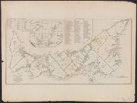
- Creator:
- Jefferys, Thomas, d. 1771
- Published / Created:
- April 6, 1775.
- Call Number:
- 7311 1775
- Container / Volume:
- BRBL_00688
- Image Count:
- 1
- Resource Type:
- Maps, Atlases & Globes
- Found in:
- Beinecke Rare Book and Manuscript Library > A map of the island of St. John in the Gulf of St. Laurence [cartographic material] : divided into counties & parishes and the lots as granted by government : to which are added the soundings round the coast & harbours / improv'd from the late survey of C
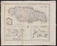
- Creator:
- Bowen, Emanuel, d. 1767
- Published / Created:
- 1747]
- Call Number:
- 8555 1747
- Container / Volume:
- BRBL_00642
- Image Count:
- 1
- Resource Type:
- Maps, Atlases & Globes
- Found in:
- Beinecke Rare Book and Manuscript Library > A new & accurate map of the Island of Jamaica [cartographic material] : divided into its principal parishes / drawn from surveys, and regulated by astronl. observatns. by Eman. Bowen.
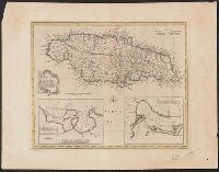
- Creator:
- Bowen, Emanuel, d. 1767
- Published / Created:
- 1747]
- Call Number:
- 8555 1752A
- Container / Volume:
- BRBL_00695
- Image Count:
- 1
- Resource Type:
- Maps, Atlases & Globes
- Found in:
- Beinecke Rare Book and Manuscript Library > A new & accurate map of the Island of Jamaica [cartographic material] : divided into its principal parishes / drawn from surveys, and regulated by astronl. observatns. by Eman. Bowen.
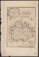
- Creator:
- Bowen, Emanuel, d. 1767
- Published / Created:
- 1747]
- Call Number:
- 8612 1747
- Container / Volume:
- BRBL_00696
- Image Count:
- 1
- Resource Type:
- Maps, Atlases & Globes
- Found in:
- Beinecke Rare Book and Manuscript Library > A new and accurate map of the island of Antigua or Antego [cartographic material] : taken from surveys, and adjusted by astronl. observations : containing all the towns, parish churches, forts, castles, windmills, roads &c. / by Eman. Bowen.
- Published / Created:
- 1762]
- Call Number:
- 855 1762A
- Container / Volume:
- BRBL_00695
- Image Count:
- 1
- Resource Type:
- Maps, Atlases & Globes
- Found in:
- Beinecke Rare Book and Manuscript Library > A new chart of the seas surrounding the island of Cuba with the soundings, currents, ships, courses &c. and a map of the island itself lately made by an officer in the Navy [cartographic material].
- Creator:
- Seller, John, fl. 1658-1698
- Published / Created:
- 1677]
- Call Number:
- 40 V55 1680A
- Image Count:
- 1
- Resource Type:
- Maps, Atlases & Globes
- Found in:
- Beinecke Rare Book and Manuscript Library > A sea chart of the Gulph of Venice : describing all the sea coasts and islands contained therein.
- Creator:
- Ogilby, John, 1600-1676
Ogilby, John, 1600-1676. Africa, being an accurate description of the regions of Egypt, Barbary
- Published / Created:
- 1670]
- Call Number:
- 214 1670
- Image Count:
- 1
- Resource Type:
- Maps, Atlases & Globes
- Found in:
- Beinecke Rare Book and Manuscript Library > Insulae Canariae alias Fortunatae dictae.