Map of the roads &c from Vera Cruz & Alvarado to Mexico., Tanner's travelling map of Mexico, and Travelling map of Mexico
Description:
"Entered according to act of Congress, in the year 1846, by H.S. Tanner in the clerks office of the district court for the southern district of New York.", Copy 2 without cover, mounted on linen., Includes distance and statistical tables and inset of "Map of the roads &c from Vera Cruz & Alvarado to Mexico" (scale [ca. 1:1,160,000])., Prime meridian: Washington., and Relief shown by hachures.
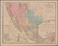
Harbor of Vera Cruz., Map of the roads &c from Vera Cruz & Alvarado to Mexico., Tanner's travelling map of Mexico, and Travelling map of Mexico
Description:
"Entered according to act of Congress, in the year 1846, by H.S. Tanner in the clerks office of the district court for the southern district of New York.", Copy 2 mounted on linen and without cover., Includes statistical and distance tables., Insets: Map of the roads &c from Vera Cruz & Alvarado to Mexico. Scale [ca. 1:1,160,000] -- Harbor of Vera Cruz. Scale [ca. 1:72,500]., Prime meridian: Washington., and Relief shown by hachures.