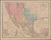
Map of the roads &c from Vera Cruz & Alvarado to Mexico., Tanner's travelling map of Mexico, and Travelling map of Mexico
Description:
"Entered according to act of Congress, in the year 1846, by H.S. Tanner in the clerks office of the district court for the southern district of New York.", Copy 2 without cover, mounted on linen., Includes distance and statistical tables and inset of "Map of the roads &c from Vera Cruz & Alvarado to Mexico" (scale [ca. 1:1,160,000])., Prime meridian: Washington., and Relief shown by hachures.
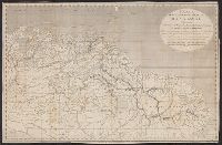
Harbor of Vera Cruz., Map of the roads &c from Vera Cruz & Alvarado to Mexico., Tanner's travelling map of Mexico, and Travelling map of Mexico
Description:
"Entered according to act of Congress, in the year 1846, by H.S. Tanner in the clerks office of the district court for the southern district of New York.", Copy 2 mounted on linen and without cover., Includes statistical and distance tables., Insets: Map of the roads &c from Vera Cruz & Alvarado to Mexico. Scale [ca. 1:1,160,000] -- Harbor of Vera Cruz. Scale [ca. 1:72,500]., Prime meridian: Washington., and Relief shown by hachures.
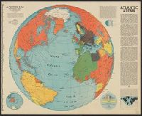
"A Fortune map.", "Centered at 35⁰N 30⁰W.", "Orthographic projection.", "Supplement to Fortune, June, 1942.", and Includes text, diagrams, and map of "The other half."
Publisher:
Time,
Subject (Geographic):
Atlantic Ocean--Maps
Subject (Topic):
World War, 1939-1945--Campaigns--Atlantic Ocean--Maps
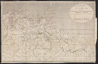
"Enlargement of original map drawn for TIME.", "For report documenting above map see TIME, January 1, 1945 issue.", and Shows U.S. counterattacks on Germans during Battle of the Bulge.
Publisher:
: TIME, Inc.,
Subject (Geographic):
Rhine River Valley--Maps
Subject (Topic):
Ardennes, Battle of the, 1944-1945--Maps and World War, 1939-1945--Campaigns--Western Front--Maps