Search
You Searched For
Search Results
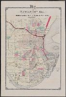
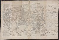
- Published / Created:
- 189-?]
- Call Number:
- 825 K134 189X
- Container / Volume:
- BRBL_00574
- Image Count:
- 1
- Resource Type:
- Maps, Atlases & Globes
- Found in:
- Beinecke Rare Book and Manuscript Library > Map of Kansas City, Kan. : showing terminals of the K.C., W. and N.W.R.R. Co.
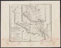
- Creator:
- Robert de Vaugondy, Didier, 1723-1786
- Published / Created:
- 1772]
- Call Number:
- 844 1772
- Container / Volume:
- BRBL_00601
- Image Count:
- 1
- Resource Type:
- Maps, Atlases & Globes
- Found in:
- Beinecke Rare Book and Manuscript Library > Carte de la Californie et des pays nord-ouest : separés de l'Asie par le Détroit d'Anian, extraite de deux cartes publiées au commencement du 17e siecle / par le S. Robert de Vaugondy ... 1772.
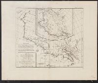
- Published / Created:
- 1772]
- Call Number:
- 844 1772A
- Container / Volume:
- BRBL_00601
- Image Count:
- 1
- Resource Type:
- Maps, Atlases & Globes
- Found in:
- Beinecke Rare Book and Manuscript Library > Carte de la Californie et des pays nord-ouest : separés de l'Asie par le Détroit d'Anian, extraite de deux cartes publiées au commencement du 17e siecle / par le S. Robert de Vaugondy ... 1772.
- Creator:
- Smith, M. L., Lieut
- Published / Created:
- 184-?]
- Call Number:
- 88 184X
- Container / Volume:
- BRBL_00645
- Image Count:
- 1
- Resource Type:
- Maps, Atlases & Globes
- Found in:
- Beinecke Rare Book and Manuscript Library > Map of the valley of Mexico, with a plan of the defences of the capital and the line of operations of the United States Army under Major General Scott in August and September 1847 / surveyed and drawn by Lieut. M.L. Smith and Brevt. Capt. E.L.F. Hardcastl
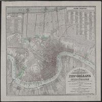
- Creator:
- Hardee, T. S
- Published / Created:
- 1878
- Call Number:
- 795 N47 1878A
- Container / Volume:
- BRBL_00522
- Image Count:
- 1
- Resource Type:
- Maps, Atlases & Globes
- Found in:
- Beinecke Rare Book and Manuscript Library > Topographical and drainage map of New Orleans and surroundings / from recent surveys and investigations by T.S. Hardee, Civil Engineer, 1878.
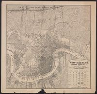
- Creator:
- Hardee, T. S
- Published / Created:
- 188-?].
- Call Number:
- 795 N47 1889
- Container / Volume:
- BRBL_00522
- Image Count:
- 1
- Resource Type:
- Maps, Atlases & Globes
- Found in:
- Beinecke Rare Book and Manuscript Library > Topographical and drainage map of New Orleans / prepared for Joseph Jones, M.D., by T.S. Hardee, civil engineer.
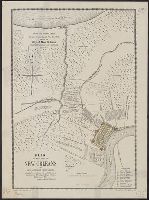
- Creator:
- Trudeau, Charles Laveau, ca. 1750-1816
- Published / Created:
- 1875
- Call Number:
- 795 N47 1798
- Container / Volume:
- BRBL_00522
- Image Count:
- 1
- Resource Type:
- Maps, Atlases & Globes
- Found in:
- Beinecke Rare Book and Manuscript Library > Plan of the city of New Orleans and adjacent plantations / compiled in accordance with and Ordinance of the Illustrious Ministry and Royal Charter, 24 December, 1798, signed: Carlos Trudeau.
- Creator:
- Hardee, T. S
- Published / Created:
- 1880?]
- Call Number:
- 795 N47 1880
- Container / Volume:
- BRBL_00522
- Image Count:
- 1
- Resource Type:
- Maps, Atlases & Globes
- Found in:
- Beinecke Rare Book and Manuscript Library > Map illustrating the topography of New Orleans and of the coast of Louisiana and Mississippi / prepared for Joseph Jones, M.D., by T.S. Hardee, civil engineer.
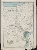
- Creator:
- Trudeau, Charles Laveau, ca. 1750-1816
- Published / Created:
- 1875
- Call Number:
- 795 N47 1798
- Container / Volume:
- BRBL_00522
- Image Count:
- 1
- Resource Type:
- Maps, Atlases & Globes
- Found in:
- Beinecke Rare Book and Manuscript Library > Plan of the city of New Orleans and adjacent plantations / compiled in accordance with and Ordinance of the Illustrious Ministry and Royal Charter, 24 December, 1798, signed: Carlos Trudeau.
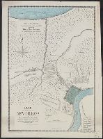
- Creator:
- United States Coast Survey
- Published / Created:
- 1864
- Call Number:
- 803cea 1864
- Container / Volume:
- BRBL_00542
- Image Count:
- 1
- Resource Type:
- Maps, Atlases & Globes
- Found in:
- Beinecke Rare Book and Manuscript Library > Ohio River between Mound City and Cairo / surveyed by the party of F.H. Gerdes, asst. assigned by A.D. Bache, Supdt. U.S. Coast Survey to act under orders of Rear Admiral D.D. Porter, U.S.N., commanding Mississippi Squadron.
- Creator:
- Peseux, M
- Published / Created:
- 1864
- Call Number:
- 801hc N17 1864
- Container / Volume:
- BRBL_00541
- Image Count:
- 1
- Resource Type:
- Maps, Atlases & Globes
- Found in:
- Beinecke Rare Book and Manuscript Library > Battlefields in front of Nashville where the United States forces commanded by Major General Geo. H. Thomas defeated and routed the Rebel army under General Hood, December 15th & 16th 1864 / surveyed and drawn under the direction of Gen: Tower by M. Peseu
- Creator:
- Anderson, Richard G., engineer
- Published / Created:
- 1897?]
- Call Number:
- 823gbc T93 1897
- Container / Volume:
- BRBL_00569
- Image Count:
- 1
- Resource Type:
- Maps, Atlases & Globes
- Found in:
- Beinecke Rare Book and Manuscript Library > Plat of the Gold Mountain and new district groups of gold mines : Two Bit Mining District, Lawrence County, South Dakota / surveyed by Richard G. Anderson, civil and mining engineer, Deadwood, South Dakota.
- Published / Created:
- 1882]
- Call Number:
- 834 C719 1882
- Container / Volume:
- BRBL_00589
- Image Count:
- 1
- Resource Type:
- Maps, Atlases & Globes
- Found in:
- Beinecke Rare Book and Manuscript Library > Map of the city of Colorado Springs, Colorado / W.P. Jewett, civil engineer, May 1882.
- Published / Created:
- 1890?]
- Call Number:
- 834 D437 1890B
- Container / Volume:
- BRBL_00589
- Image Count:
- 1
- Resource Type:
- Maps, Atlases & Globes
- Found in:
- Beinecke Rare Book and Manuscript Library > Map of Denver-Colorado and the town of Montclair.
- Creator:
- De Werthern, H
- Published / Created:
- 1869]
- Call Number:
- 836 1869
- Container / Volume:
- BRBL_00592
- Image Count:
- 1
- Resource Type:
- Maps, Atlases & Globes
- Found in:
- Beinecke Rare Book and Manuscript Library > Map of Utah and Colorado / prepared by order of Lieut. Genl. W.T. Sherman ; drawn by H. De Werthern.
- Published / Created:
- 1915?]
- Call Number:
- 331 W14 1915
- Container / Volume:
- BRBL_00080
- Image Count:
- 1
- Resource Type:
- Maps, Atlases & Globes
- Found in:
- Beinecke Rare Book and Manuscript Library > The ancient tidal channels of Walcheren.
- Published / Created:
- 1937?]
- Call Number:
- 304fdb 1937
- Container / Volume:
- BRBL_00034B
- Image Count:
- 1
- Resource Type:
- Maps, Atlases & Globes
- Found in:
- Beinecke Rare Book and Manuscript Library > Political map of central Europe.
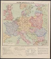
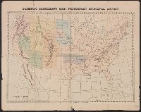
- Published / Created:
- 1874]
- Call Number:
- 75eha 1873
- Image Count:
- 1
- Resource Type:
- Maps, Atlases & Globes
- Found in:
- Beinecke Rare Book and Manuscript Library > Domestic missionary map, Protestant Episcopal Church.
- Published / Created:
- 1860?]
- Call Number:
- 40 V867 1860E
- Container / Volume:
- BRBL_00227
- Image Count:
- 1
- Resource Type:
- Maps, Atlases & Globes
- Found in:
- Beinecke Rare Book and Manuscript Library > Cne. di Voghera Fo. LXI.
- Published / Created:
- 1780?]
- Call Number:
- 771cea N49 1780
- Container / Volume:
- BRBL_00493
- Image Count:
- 1
- Resource Type:
- Maps, Atlases & Globes
- Found in:
- Beinecke Rare Book and Manuscript Library > New York Harbour.
- Published / Created:
- 1840?]
- Call Number:
- 7715FB AS88 1840
- Container / Volume:
- BRBL_00493
- Image Count:
- 1
- Resource Type:
- Maps, Atlases & Globes
- Found in:
- Beinecke Rare Book and Manuscript Library > Map of the village of Astoria, Late Hallett's Cove & Ravenswood, Long Island, 1840.
- Creator:
- George B. Cadwell & Co
- Published / Created:
- 1892
- Call Number:
- 811 T227 1892
- Container / Volume:
- BRBL_00553
- Image Count:
- 1
- Resource Type:
- Maps, Atlases & Globes
- Found in:
- Beinecke Rare Book and Manuscript Library > Map of Tecumseh : compiled for Geo. B. Cadwell & Co's. atlas of Lenawee County, Mich.
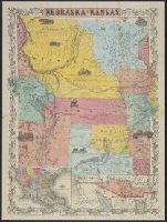
- Creator:
- J.H. Colton & Co
- Published / Created:
- 19--?]
- Call Number:
- 824 1854B
- Container / Volume:
- BRBL_00570
- Image Count:
- 1
- Resource Type:
- Maps, Atlases & Globes
- Found in:
- Beinecke Rare Book and Manuscript Library > Nebraska and Kansas.
- Creator:
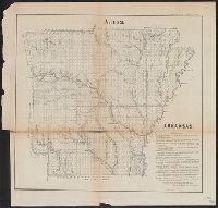
- Arkansas. Surveyor's Office
- Published / Created:
- 1855]
- Call Number:
- 818 1855B
- Container / Volume:
- BRBL_00565
- Image Count:
- 1
- Resource Type:
- Maps, Atlases & Globes
- Found in:
- Beinecke Rare Book and Manuscript Library > Arkansas / Surveyor's Office Little Rock Oct. 18th 1855. Henry M. Rector, Sur. Genl. of Arks.
- Published / Created:
- 1847 or 1848?]
- Call Number:
- 816fcm 1847
- Container / Volume:
- BRBL_00563
- Image Count:
- 1
- Resource Type:
- Maps, Atlases & Globes
- Found in:
- Beinecke Rare Book and Manuscript Library > Diagram of the state of Missouri.
- Published / Created:
- 1845?]
- Call Number:
- 818fb 1845
- Container / Volume:
- BRBL_00565
- Image Count:
- 1
- Resource Type:
- Maps, Atlases & Globes
- Found in:
- Beinecke Rare Book and Manuscript Library > Map of the south western district, Louisiana ; South eastern district, Louisiana ; Map of the district north of Red River and part of N.W. District, LA. / Surveyor Generals Office, Donaldson, Oct. 29th 1845, P.T. Landry, Sur. Genl. La. Arkansas / Wm. Pel
- Creator:
- Shepard, Edwin
- Published / Created:
- 1877]
- Call Number:
- 844 Sa593 1877
- Container / Volume:
- BRBL_00610
- Image Count:
- 1
- Resource Type:
- Maps, Atlases & Globes
- Found in:
- Beinecke Rare Book and Manuscript Library > City of Santa Cruz, California, 1877 / compiled by Edwin Shepard.
- Published / Created:
- 1920?].
- Call Number:
- 902 1920A
- Container / Volume:
- BRBL_00665
- Image Count:
- 1
- Resource Type:
- Maps, Atlases & Globes
- Found in:
- Beinecke Rare Book and Manuscript Library > [Map of Colombia].
- Published / Created:
- 1915?]
- Call Number:
- 884 1915A
- Container / Volume:
- BRBL_00654
- Image Count:
- 1
- Resource Type:
- Maps, Atlases & Globes
- Found in:
- Beinecke Rare Book and Manuscript Library > [Map of region around Tamiahua Lagoon].
- Published / Created:
- 1913].
- Call Number:
- 897fda 1913
- Container / Volume:
- BRBL_00659
- Image Count:
- 1
- Resource Type:
- Maps, Atlases & Globes
- Found in:
- Beinecke Rare Book and Manuscript Library > [Map illustrating Costa Rica-Panama boundary dispute].
- Creator:
- Ferrer, Fermin
- Published / Created:
- 1855
- Call Number:
- 895 1855
- Container / Volume:
- BRBL_00659
- Image Count:
- 1
- Resource Type:
- Maps, Atlases & Globes
- Found in:
- Beinecke Rare Book and Manuscript Library > Geographical map of the Republic of Nicaragua : with three plans and views / by Fermin Ferrer, Governor of the Western Dept.
- Published / Created:
- 1919
- Call Number:
- 11hcf 1919B-50
- Container / Volume:
- BRBL_00010S
- Image Count:
- 4
- Resource Type:
- Maps, Atlases & Globes
- Found in:
- Beinecke Rare Book and Manuscript Library > [4 Ethnographic Maps of Central Europe] / Dess. par A.D. Alanasiu.
- Published / Created:
- 1915?].
- Call Number:
- 38 C39 1915
- Container / Volume:
- BRBL_00156
- Image Count:
- 4
- Resource Type:
- Maps, Atlases & Globes
- Found in:
- Beinecke Rare Book and Manuscript Library > Plan de la ville de Chauny.
- Published / Created:
- c1949.
- Call Number:
- 846 P837 1949A
- Container / Volume:
- BRBL_00622
- Image Count:
- 4
- Resource Type:
- Maps, Atlases & Globes
- Found in:
- Beinecke Rare Book and Manuscript Library > [Street map of Portland, Or.].
- Published / Created:
- 1633?]
- Call Number:
- 322 1633
- Container / Volume:
- BRBL_00059
- Image Count:
- 2
- Resource Type:
- Maps, Atlases & Globes
- Found in:
- Beinecke Rare Book and Manuscript Library > [Channel Islands]
- Published / Created:
- [ca. 1940?]
- Call Number:
- 331 D72 1940
- Container / Volume:
- BRBL_00079
- Image Count:
- 2
- Resource Type:
- Maps, Atlases & Globes
- Found in:
- Beinecke Rare Book and Manuscript Library > Stadtplan von Dordrecht.
- Published / Created:
- 1880?]
- Call Number:
- 3627 B14 1880
- Image Count:
- 2
- Resource Type:
- Maps, Atlases & Globes
- Found in:
- Beinecke Rare Book and Manuscript Library > Baierbrunn.
- Published / Created:
- ca. 1942]
- Call Number:
- 36 Sa12 1942
- Container / Volume:
- BRBL_00126
- Image Count:
- 2
- Resource Type:
- Maps, Atlases & Globes
- Found in:
- Beinecke Rare Book and Manuscript Library > [Facsimile map of Saarbrücken, Germany].
- Creator:
- Löwe, Cornelius
Pharus-Verlag
United States. Office of Strategic Services. Geography Division. Map Information Section
- Published / Created:
- ca. 1942]
- Call Number:
- 36 L65 1942
- Container / Volume:
- BRBL_00125
- Image Count:
- 2
- Resource Type:
- Maps, Atlases & Globes
- Found in:
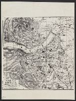
- Beinecke Rare Book and Manuscript Library > [Facsimile map of Linz, Austria].
- Published / Created:
- 1869
- Call Number:
- 428 1869
- Container / Volume:
- BRBL_00247
- Image Count:
- 2
- Resource Type:
- Maps, Atlases & Globes
- Found in:
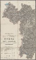
- Beinecke Rare Book and Manuscript Library > Generalkarte der Gefürsten Grafschaft Tyrol nebst Vorarlberg und dem Souverainen Fürstenthume Liechtenstein.
- Published / Created:
- 1886
- Call Number:
- 44 1886
- Container / Volume:
- BRBL_00255
- Image Count:
- 2
- Resource Type:
- Maps, Atlases & Globes
- Found in:
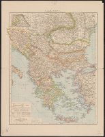
- Beinecke Rare Book and Manuscript Library > Balkanhalbinsel.
- Published / Created:
- 1919?]
- Call Number:
- 11hcf 1919B-20-10
- Container / Volume:
- BRBL_00010P
- Image Count:
- 2
- Resource Type:
- Maps, Atlases & Globes
- Found in:
- Beinecke Rare Book and Manuscript Library > A Magyarorszagi Nepfajok Délen / Tervezte: Balogh Pál ; Rajzolta: Br. Proff Kocsárd.
- Published / Created:
- 1919?]
- Call Number:
- 11hcf 1919B-11
- Image Count:
- 2
- Resource Type:
- Maps, Atlases & Globes
- Found in:
- Beinecke Rare Book and Manuscript Library > [Portion of map of France and Germany].
- Published / Created:
- 1919?]
- Call Number:
- 11hcf 1919B-20-7
- Container / Volume:
- BRBL_00010P
- Image Count:
- 2
- Resource Type:
- Maps, Atlases & Globes
- Found in:
- Beinecke Rare Book and Manuscript Library > A Magyarorszagi Nepfajok Az Ország Mélyén / Tervezte: Balogh Pál ; Rajzolta: Br. Proff Kocsárd.
- Published / Created:
- 1919?]
- Call Number:
- 11hcf 1919B-20-10
- Container / Volume:
- BRBL_00010P
- Image Count:
- 2
- Resource Type:
- Maps, Atlases & Globes
- Found in:
- Beinecke Rare Book and Manuscript Library > A Magyarorszagi Nepfajok Délen / Tervezte: Balogh Pál ; Rajzolta: Br. Proff Kocsárd.
- Published / Created:
- 1919?]
- Call Number:
- 11hcf 1919B-20-13
- Container / Volume:
- BRBL_00010P
- Image Count:
- 2
- Resource Type:
- Maps, Atlases & Globes
- Found in:
- Beinecke Rare Book and Manuscript Library > A Magyarorszagi Nepfajok Delkeleten / Tervezte: Balogh Pál ; Rajzolta: Br. Proff Kocsárd.
- Published / Created:
- 1850]
- Call Number:
- 40 B75 1850
- Container / Volume:
- BRBL_00205
- Image Count:
- 2
- Resource Type:
- Maps, Atlases & Globes
- Found in:
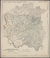
- Beinecke Rare Book and Manuscript Library > Corografia della Provincia di Brescia nel Regno Lombardo-Veneto : distinta ne' suoi distretti e comuni censuari formata in base delle mappe del nuovo censimento.
- Published / Created:
- 1850?]
- Call Number:
- 40 B41 1850
- Container / Volume:
- BRBL_00204
- Image Count:
- 2
- Resource Type:
- Maps, Atlases & Globes
- Found in:
- Beinecke Rare Book and Manuscript Library > Corografia della provincia di Belluno nel Regno Lombardo Veneto : distinta ne' suoi distretti e comuni censuari, formata in base delle mappe del nuovo censimento.
- Published / Created:
- 1860?]
- Call Number:
- 428 B63 1860
- Container / Volume:
- BRBL_00248
- Image Count:
- 2
- Resource Type:
- Maps, Atlases & Globes
- Found in:
- Beinecke Rare Book and Manuscript Library > Umgebungs-Karte von Bozen.