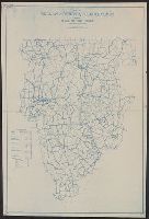
Blue line print., In lower left corner: R.W.D., Nov. 21, 1910. R 12-1-10. S, 4/1/12-S2 4/1/12., In lower right margin: Tolland Co. Conn, 905., and Indicates lettered routes, post offices, houses, schools, churches, and collection boxes.
Publisher:
s.n.],
Subject (Geographic):
Tolland County (Conn.)--Maps
Subject (Topic):
Postal service--Connecticut--Tolland County--Maps and Rural free delivery--Connecticut--Tolland County--Maps
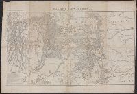
"Bvt. Maj. Gen. A.A. Humphreys, Chief of Engineers.", "Compiled under the direction of Bvt. Col. Wm. F. Merrill, Maj. Engrs, St. Louis, 1869.", Also shows parts of adjoining states., Includes list of "authorities.", and Relief shown by hachures.
Publisher:
s.n.,
Subject (Geographic):
Colorado--Maps and Utah--Maps
Subject (Name):
Humphreys, A. A. (Andrew Atkinson), 1810-1883, Merrill, Wm. F, R.P. Studley Co, and Sherman, William T. (William Tecumseh), 1820-1891
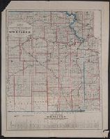
General profile of the road-bed of the Mo.R.F.S. & G.R.R., showing the elevation of the road bed, stations, streams & summits, relative distances & gradients.
Description:
Date inferred from status of Miissouri River, Fort Scott & Gulf Railroad, shown complete to Baxter Springs (1870). and Includes "General profile of the road-bed of the Mo.R.F.S. & G.R.R., showing the elevation of the road bed, stations, streams & summits; relative distances & gradients" (scale vertical [1:4,800] and horizontal [1:480,000]).
Includes inset of D. Russ Wood addition and advertisement. and Shows township lines, water pipes, gas pipes, fire plugs, street names and places of interest.
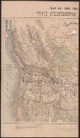
Difference between the elevations of the Northern Pacific and the Union Pacific Railroads.
Description:
Covers northern United States from Lake Michigan to Pacific Ocean, and parts of Canada., Includes distance list, text, and profile of "Difference between the elevations of the Northern Pacific and the Union Pacific Railroads.", Relief shown by hachures and spot heights., and Shows cities and towns, coal fields, forts, isotherms, routes and trails, the railroad network and the proposed Northern Pacific Railroad. The line was constructed under an act of Congress approved by Abraham Lincoln, July 2, 1864. It was completed in 1883 and approximates the route of exploration taken by Lewis and Clark in 1804-06.
Publisher:
s.n.,
Subject (Name):
Northern Pacific Railroad Company and Northern Pacific Railroad Company--Maps
Subject (Topic):
Coal mines and mining--Canada--Maps, Coal mines and mining--Northwestern States--Maps, and Railroads--Northwestern States--Maps