Search
You Searched For
Search Results
- Creator:
- Geological Survey (U.S.)
- Published / Created:
- 1906
- Call Number:
- 771cbf Al13 1906
- Image Count:
- 1
- Resource Type:
- Maps, Atlases & Globes
- Found in:
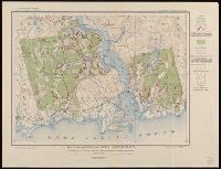
- Beinecke Rare Book and Manuscript Library > Albany and vicinity, New York.
- Creator:
- Geological Survey (U.S.)
- Published / Created:
- 1910
- Call Number:
- BrSides Double Folio 2019 84
- Image Count:
- 1
- Resource Type:
- Maps, Atlases & Globes
- Found in:
- Beinecke Rare Book and Manuscript Library > Colorado (Lake County), Leadville special map [cartographic material] / triangulation and topography by A.D. Wilson, chief topographer.
- Creator:
- Geological Survey (U.S.)
- Published / Created:
- 1906
- Call Number:
- BrSides Folio 2019 61
- Image Count:
- 1
- Resource Type:
- Maps, Atlases & Globes
- Found in:
- Beinecke Rare Book and Manuscript Library > Colorado, Central City special map [cartographic material] / U.S. Geological Survey ; E.M. Douglas, geographer ; Frank Tweedy, in charge of section ; topography by Pearson Chapman and D.F. Moor ; triangulation by Frank Tweedy.
- Creator:
- Geological Survey (U.S.)
- Published / Created:
- [1900]
- Call Number:
- 847gc Se18 1897
- Container / Volume:
- BRBL_00628
- Image Count:
- 1
- Resource Type:
- Maps, Atlases & Globes
- Found in:
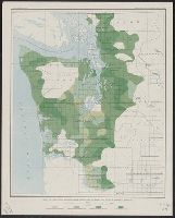
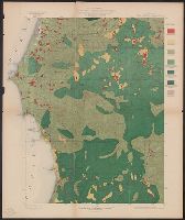
- Beinecke Rare Book and Manuscript Library > Land classification and density of standing timber, Washington, Seattle quadrangle / U.S. Geological Survey.
- Creator:
- Geological Survey (U.S.)
- Published / Created:
- [1900]
- Call Number:
- 847gc T119 1897
- Container / Volume:
- BRBL_00628
- Image Count:
- 1
- Resource Type:
- Maps, Atlases & Globes
- Found in:
- Beinecke Rare Book and Manuscript Library > Land classification and density of standing timber, Washington, Tacoma quadrangle / U.S. Geological Survey.
- Creator:
- Geological Survey (U.S.)
- Published / Created:
- 1913
- Call Number:
- BrSides Double Folio 2019 127
- Image Count:
- 1
- Resource Type:
- Maps, Atlases & Globes
- Found in:
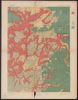
- Beinecke Rare Book and Manuscript Library > Leadville mining district [cartographic material] / U.S. Geological Survey ; R.B. Marshall, chief geographer ; Sledge Tatum, geographer in charge ; topography by E.P. Davis and S.E. Taylor ; control by R.B. Robertson, C.H. Semper, and S.E. Taylor.
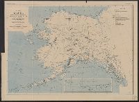
- Creator:
- Geological Survey (U.S.)
- Published / Created:
- 1908
- Call Number:
- 848gbc 1908
- Container / Volume:
- BRBL_00635
- Image Count:
- 1
- Resource Type:
- Maps, Atlases & Globes
- Found in:
- Beinecke Rare Book and Manuscript Library > Map of Alaska showing the known distribution of mineral resources / U.S. Geological Survey, compiled under the direction of Alfred H. Brooks, Geologist in charge of Division of Alaskan Mineral Resources, U.S. Geological Survey.
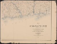
- Creator:
- Geological Survey (U.S.)
- Published / Created:
- 1893
- Call Number:
- 766 1893
- Container / Volume:
- BRBL_00467
- Image Count:
- 4
- Resource Type:
- Maps, Atlases & Globes
- Found in:
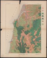
- Beinecke Rare Book and Manuscript Library > Map of Connecticut / prepared by the U.S. Geological Survey in co-operation with the State of Connecticut.
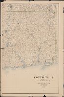
- Creator:
- Geological Survey (U.S.)
- Published / Created:
- 1893 (1899 printing)
- Call Number:
- 766 1893C
- Container / Volume:
- BRBL_00467
- Image Count:
- 2
- Resource Type:
- Maps, Atlases & Globes
- Found in:
- Beinecke Rare Book and Manuscript Library > Map of Connecticut / prepared by the U.S. Geological Survey in co-operation with the State of Connecticut.
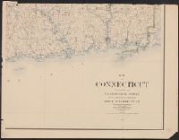
- Creator:
- Geological Survey (U.S.)
- Published / Created:
- 1893 (1899 printing)
- Call Number:
- 766 1893C
- Container / Volume:
- BRBL_00467
- Image Count:
- 3
- Resource Type:
- Maps, Atlases & Globes
- Found in:
- Beinecke Rare Book and Manuscript Library > Map of Connecticut / prepared by the U.S. Geological Survey in co-operation with the State of Connecticut.
- Creator:
- Geological Survey (U.S.)
- Published / Created:
- 1912
- Call Number:
- 71 1912
- Container / Volume:
- BRBL_00371
- Image Count:
- 1
- Resource Type:
- Maps, Atlases & Globes
- Found in:
- Beinecke Rare Book and Manuscript Library > Map of North America : reduced from map on scale of 1:5,000,000 / compiled by the U.S. Geological Survey.
- Creator:
- Geological Survey (U.S.)
- Published / Created:
- 1915
- Call Number:
- 766C Sa99 1915
- Container / Volume:
- BRBL_00474
- Image Count:
- 1
- Resource Type:
- Maps, Atlases & Globes
- Found in:
- Beinecke Rare Book and Manuscript Library > Map of Saybrook area, Connecticut, showing rock outcrops, wooded areas, and ground-water conditions.
- Creator:
- Geological Survey (U.S.)
- Published / Created:
- [1898].
- Call Number:
- 847gc 1898
- Container / Volume:
- BRBL_00628
- Image Count:
- 1
- Resource Type:
- Maps, Atlases & Globes
- Found in:
- Beinecke Rare Book and Manuscript Library > Map of Western Washington showing density of merchantable timber / U.S. Geological Survey.
- Creator:
- Geological Survey (U.S.)
- Published / Created:
- [1918]
- Call Number:
- 844fcm Y83 1918
- Container / Volume:
- BRBL_00615
- Image Count:
- 1
- Resource Type:
- Maps, Atlases & Globes
- Found in:
- Beinecke Rare Book and Manuscript Library > Map of Yosemite Valley, Yosemite National Park, California, Mariposa County / U.S. Geological Survey ; State of California ; E.M. Douglas, geographer ; R.B. Marshall, in charge of section ; topography by F.E. Matthes ; triangulation by C.F. Urquhart.
- Creator:
- Geological Survey (U.S.)
- Published / Created:
- 1913
- Call Number:
- 75ed 1913
- Container / Volume:
- BRBL_00410
- Image Count:
- 1
- Resource Type:
- Maps, Atlases & Globes
- Found in:
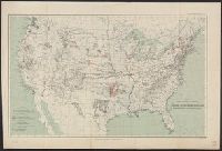
- Beinecke Rare Book and Manuscript Library > Map showing Indian Reservations within the Limits of the United States, 1913 / engraved and printed by the U.S. Geological Survey.
- Creator:
- Geological Survey (U.S.)
- Published / Created:
- [1897]
- Call Number:
- 75BF 1897
- Container / Volume:
- BRBL_00407A
- Image Count:
- 1
- Resource Type:
- Maps, Atlases & Globes
- Found in:
- Beinecke Rare Book and Manuscript Library > Map showing condition and progress of astronomic location, primary triangulation, primary traverse and precise leveling, for the fiscal year 1896-7.
- Creator:
- Geological Survey (U.S.)
- Published / Created:
- [1897]
- Call Number:
- 75BH 1897
- Container / Volume:
- BRBL_00407A
- Image Count:
- 1
- Resource Type:
- Maps, Atlases & Globes
- Found in:
- Beinecke Rare Book and Manuscript Library > Map showing condition and progress of topographic surveys and location of gaging stations for the fiscal year 1896-1897.
- Creator:
- Geological Survey (U.S.)
- Published / Created:
- [1900]
- Call Number:
- 846gc C786 1896
- Container / Volume:
- BRBL_00623
- Image Count:
- 1
- Resource Type:
- Maps, Atlases & Globes
- Found in:
- Beinecke Rare Book and Manuscript Library > Oregon, Coos Bay quadrangle : land classification and density of standing timber / U.S. Geological Survey ; R.U. Goode, geographer in charge ; triangulation by W.T. Griswold ; topography by E.C. Barnard ; Henry Gannett, geographer in charge ; land classif
- Creator:
- Geological Survey (U.S.)
- Published / Created:
- [1900].
- Call Number:
- 846gc P838 1898
- Container / Volume:
- BRBL_00623
- Image Count:
- 1
- Resource Type:
- Maps, Atlases & Globes
- Found in:
- Beinecke Rare Book and Manuscript Library > Oregon, Port Orford quadrangle : land classification and density of standing timber / U.S. Geological Survey ; R.U. Goode, geographer in charge ; triangulation by W.T. Griswold ; topography by A.E. Murlin ; Henry Gannett, geographer in charge ; land class
- Creator:
- Geological Survey (U.S.)
- Published / Created:
- [1900].
- Call Number:
- 846gc R72 1895
- Container / Volume:
- BRBL_00623
- Image Count:
- 1
- Resource Type:
- Maps, Atlases & Globes
- Found in:
- Beinecke Rare Book and Manuscript Library > Oregon, Roseburg quadrangle : land classification and density of standing timber / U.S. Geological Survey ; Henry Gannett, chief topographer ; R.U. Goode, geographer in charge ; triangulation by W.T. Griswold ; topography by E.C. Barnard ; Henry Gannett,