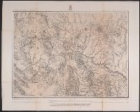
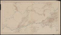
Geographical Surveys West of the 100th Meridian (U.S.)
Published / Created:
1876
Call Number:
842 1876A
Container / Volume:
BRBL_00598
Image Count:
1
Resource Type:
Maps, Atlases & Globes
Description:
"5"--Verso., "Expeditions of 1871-1872 & 1873 under the comman, "Weyss, Herman & Lang, del."--Margin., Relief shown by hachures and spot heights., and Sheet no. 75 from Wheeler's Geographical exploration and surveys west of the 100th meridian topographical atlas.
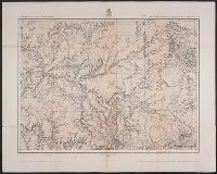
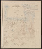
Geographical Surveys West of the 100th Meridian (U.S.)
Published / Created:
[1876]
Call Number:
842 1876C
Container / Volume:
BRBL_00598
Image Count:
1
Resource Type:
Maps, Atlases & Globes
Description:
"Atlas sheet no. 83.", "Expeditions of 1871 & 1873 under the command of 1st. Lieut. Geo. M. Wheeler, Corps of Engineers, U.S. Army.", "Issued Mar. 18th 1876.", "Weyss, Herman & Lang, del.", and Relief shown by hachures and spot heights.
Publisher:
[U.S. Geographical Surveys West of the 100th Meridian],
Subject (Geographic):
Arizona--Surveys--Maps and New Mexico--Surveys--Maps
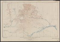
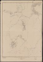
Geological and Geographical Survey of the Territories (U.S.)
Published / Created:
[1877]
Call Number:
833ca 1878AB
Container / Volume:
BRBL_00585
Image Count:
1
Resource Type:
Maps, Atlases & Globes
Description:
"56" printed in bottom right margin., Backed with linen. Stamp at top "10" crossed out with manuscript "No. 5" below., Relief shown by contours and spot heights., and Shows roads, springs, settlements, etc.
Publisher:
[The Survey],
Subject (Geographic):
Idaho--Maps, Utah--Maps, and Wyoming--Maps
Subject (Name):
Bien, Julius, 1829-1909, Gannett, Henry, 1846-1914, and Hayden, F. V. (Ferdinand Vandeveer), 1829-1887
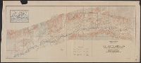
"Surveyed in 1903; additional areas from surveys made in 1900 and 1901 by U.S. Geological Survey". and Relief shown by contours; contour interval 200 feet.
Publisher:
U.S.G.S.,
Subject (Geographic):
Seward Peninsula (Alaska)--Maps
Subject (Name):
Brooks, Alfred H. (Alfred Hulse), 1871-1924 and Witherspoon, D. C
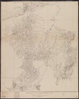
"Surveyed in 1898, 1914,1915,1916, and 1919.", Key map of surveyors' areas of responsiblity in margin., and Relief shown by contours, land forms and spot heights.
Publisher:
Geological Survey,
Subject (Geographic):
Kuskokwim Bay Region (Alaska)--Maps and Kuskokwim River Region (Alaska)--Maps
Subject (Name):
Brooks, Alfred H. (Alfred Hulse), 1871-1924, Maddren, A. G, Post, W. S, and Sargent, Rufus Harvey, b. 1875
"Surveyed in 1909 and 1913 ; topography by Alaskan Branch, R.H. Sargent, topographic engineer.", Includes regional location map., and Relief shown by contours and spot heights.