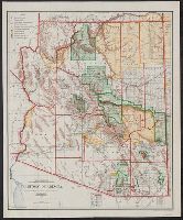
Includes inset of the Sonora railway and township diagram showing sections and quarter-sections., Prime meridians: Washington and Greenwich., Relief shown by shading., and Shows counties, Indian, forest, and military reserves, private land grants, and townships.
Publisher:
General Land Office,
Subject (Geographic):
Arizona--Administrative and political divisions--Maps and Arizona--Maps
Subject (Name):
Bond, Frank, 1856-1940, Norris Peters Co, and United States. General Land Office
Subject (Topic):
Forest reserves--Arizona--Maps and Indian reservations--Arizona--Maps
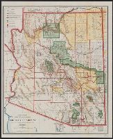
Includes inset of the Sonora railway and township diagram., Prime meridians: Greenwich and Washington., Relief shown by shading., and Shows counties, Indian, forest, and military reserves, private land grants, and townships.
Publisher:
The Office,
Subject (Geographic):
Arizona--Administrative and political divisions--Maps and Arizona--Maps
Subject (Name):
Bond, Frank, 1856-1940 and United States. General Land Office
Subject (Topic):
Forest reserves--Arizona--Maps and Indian reservations--Arizona--Maps