Search
You Searched For
Search Results
- Creator:
- Maury, Matthew Fontaine, 1806-1873
- Published / Created:
- 1853
- Call Number:
- 11DB 1851A-2
- Container / Volume:
- BRBL_00774
- Image Count:
- 1
- Resource Type:
- Maps, Atlases & Globes
- Found in:
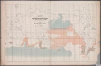
- Beinecke Rare Book and Manuscript Library > A chart showing the favorite resort of the sperm and right whale [cartographic material] / by M.F. Maury L.L.D. Lieut. U.S. Navy ; constructed from Maury's whale chart of the world by Robt. H. Wyman Lieut. U.S.N.
- Creator:
- Graham, J. D. (James Duncan), 1799-1865
- Published / Created:
- 1836
- Call Number:
- 764 C172 1836
- Container / Volume:
- BRBL_00456A
- Image Count:
- 4
- Resource Type:
- Maps, Atlases & Globes
- Found in:
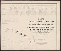
- Beinecke Rare Book and Manuscript Library > A map of the extremity of Cape Cod : including the townships of Provincetown & Truro, with a chart of their sea coast and of Cape Cod Harbour, State of Massachusetts / executed under the direction of Major J.D. Graham ... 1833, '34, & '35.
- Creator:
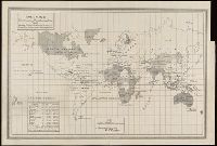
- United States. Dept. of the Treasury. Bureau of Statistics
- Published / Created:
- [1899]
- Call Number:
- 60fab 1899A
- Container / Volume:
- BRBL_00329
- Image Count:
- 1
- Resource Type:
- Maps, Atlases & Globes
- Found in:
- Beinecke Rare Book and Manuscript Library > Africa, its political divisions and commercial routes / Norris Peters Co., photo-litho., Washington, D.C.
- Creator:
- United States. Dept. of the Treasury. Bureau of Statistics
- Published / Created:
- 1899
- Call Number:
- 60fab 1899
- Container / Volume:
- BRBL_00329
- Image Count:
- 1
- Resource Type:
- Maps, Atlases & Globes
- Found in:
- Beinecke Rare Book and Manuscript Library > Africa, its political divisions and commercial routes / Norris Peters Co., photo-litho., Washington, D.C.
- Creator:
- United States Coast Survey
- Published / Created:
- 1869
- Call Number:
- 848 1869
- Container / Volume:
- BRBL_00630
- Image Count:
- 1
- Resource Type:
- Maps, Atlases & Globes
- Found in:
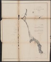
- Beinecke Rare Book and Manuscript Library > Alaska and adjoining territory / drawn by H. Lindenkohl.
- Creator:
- Geological Survey (U.S.)
- Published / Created:
- 1898
- Call Number:
- 848 C793 1898
- Container / Volume:
- BRBL_00632
- Image Count:
- 1
- Resource Type:
- Maps, Atlases & Globes
- Found in:
- Beinecke Rare Book and Manuscript Library > Alaska military expedition : in charge of Captain W.R. Abercrombie, U.S.A. Copper River and adjacent territory / topography by P.G. Lowe, F.C. Schrader, and Emil Mahlo.
- Creator:
- U.S. Coast and Geodetic Survey
- Published / Created:
- 1880
- Call Number:
- 75AK 1880
- Container / Volume:
- BRBL_00407A
- Image Count:
- 1
- Resource Type:
- Maps, Atlases & Globes
- Found in:
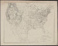
- Beinecke Rare Book and Manuscript Library > Base-map of the United States / Drawn and engraved by A. and H. Lindenkohl.
- Creator:
- Peirce, Benjamin, 1809-1880
United States Coast Survey
- Published / Created:
- 1869
- Call Number:
- 846cea Or4 1869
- Container / Volume:
- BRBL_00623
- Image Count:
- 1
- Resource Type:
- Maps, Atlases & Globes
- Found in:
- Beinecke Rare Book and Manuscript Library > Cape Orford and reef, Oregon / U.S. Coast Survey, Benjamin Peirce, superintendant ; triangulation by A.W. Chase, sub-assistant in 1869 ; topography by A.M. Harrison, assist. and A.W. Chase, sub-assistant in 1851 & '69 ; hydrography by Commander J. Alden U
- Creator:
- United States. Bureau of Statistics
- Published / Created:
- [1898]
- Call Number:
- BrSides Folio 2019 4
- Image Count:
- 1
- Resource Type:
- Maps, Atlases & Globes
- Found in:
- Beinecke Rare Book and Manuscript Library > Colonies, dependencies and protectorates of the world [cartographic material] : showing area and population of the colonies, dependencies, protectorates and spheres of influence.
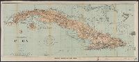
- Creator:
- U.S. Coast and Geodetic Survey
- Published / Created:
- 1898
- Call Number:
- 855hc 1898Q
- Container / Volume:
- BRBL_00765
- Image Count:
- 1
- Resource Type:
- Maps, Atlases & Globes
- Found in:
- Beinecke Rare Book and Manuscript Library > Cuba : part of chart "E" / Treasury Department, U.S. Coast and Geodetic Survey, Henry S. Pritchett, Superintendent.