Search
You Searched For
Search Results
- Published / Created:
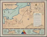
- [1944?]
- Call Number:
- 307hc 1944
- Container / Volume:
- BRBL_00036A
- Image Count:
- 1
- Resource Type:
- Maps, Atlases & Globes
- Found in:
- Beinecke Rare Book and Manuscript Library > "Hell on Wheels" 1942-1943-1944.
- Creator:
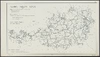
- United States. Hydrographic Office
- Published / Created:
- [1851?]
- Call Number:
- 74cea 1851
- Container / Volume:
- BRBL_00394
- Image Count:
- 1
- Resource Type:
- Maps, Atlases & Globes
- Found in:
- Beinecke Rare Book and Manuscript Library > A chart illustrative of the cruise of the American Arctic expedition in search of Sir John Franklin, in the years 1850 & 1851.
- Published / Created:
- 1863-1864.
- Call Number:
- 75cea 1864
- Container / Volume:
- BRBL_00409
- Image Count:
- 2
- Resource Type:
- Maps, Atlases & Globes
- Found in:
- Beinecke Rare Book and Manuscript Library > Atlantic Coast of the United States (in four sheets).
- Creator:
- United States. Office of Strategic Services. Research and Analysis Branch
- Published / Created:
- 1944
- Call Number:
- 42gmb 1944
- Container / Volume:
- BRBL_00245
- Image Count:
- 1
- Resource Type:
- Maps, Atlases & Globes
- Found in:
- Beinecke Rare Book and Manuscript Library > Austria [cartographic material] : Federal roads 1937.
- Published / Created:
- 1849
- Call Number:
- 771cea B98 1849
- Container / Volume:
- BRBL_00493
- Image Count:
- 1
- Resource Type:
- Maps, Atlases & Globes
- Found in:
- Beinecke Rare Book and Manuscript Library > B No.2 Sketch of Buttermilk Channel New York Harbor by the Hydrographic party of the Coast Survey ...
- Creator:
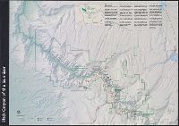
- United States. National Park Service
- Published / Created:
- [2001]
- Call Number:
- 834 B52 2001
- Container / Volume:
- BRBL_00589
- Image Count:
- 2
- Resource Type:
- Maps, Atlases & Globes
- Found in:
- Beinecke Rare Book and Manuscript Library > Black Canyon of the Gunnison National Park, Colorado / National Park Service, U.S. Department of the Interior.
- Creator:
- United States. National Park Service
- Published / Created:
- [1980]
- Call Number:
- 836 B51 1980
- Container / Volume:
- BRBL_00592
- Image Count:
- 2
- Resource Type:
- Maps, Atlases & Globes
- Found in:
- Beinecke Rare Book and Manuscript Library > Bryce Canyon National Park, Utah / National Park Service, U.S. Department of the Interior.
- Creator:
- United States. Office of Strategic Services. Research and Analysis Branch
- Published / Created:
- 1943
- Call Number:
- 47gme 1943
- Container / Volume:
- BRBL_00261
- Image Count:
- 1
- Resource Type:
- Maps, Atlases & Globes
- Found in:
- Beinecke Rare Book and Manuscript Library > Bulgaria, railroads and railroad facilities [cartographic material] / compiled and drawn in the Branch of Research and Analysis, OSS.
- Creator:
- United States. Bureau of the Census
- Published / Created:
- 1934
- Call Number:
- 844fb 1930
- Container / Volume:
- BRBL_00614
- Image Count:
- 1
- Resource Type:
- Maps, Atlases & Globes
- Found in:
- Beinecke Rare Book and Manuscript Library > California : minor civil divisions / Bureau of the Census, 1930.
- Creator:
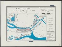
- United States. Office of Strategic Services
- Published / Created:
- 1945
- Call Number:
- 56 Sh43 1945
- Container / Volume:
- BRBL_00297
- Image Count:
- 1
- Resource Type:
- Maps, Atlases & Globes
- Found in:
- Beinecke Rare Book and Manuscript Library > China, south coast [cartographic material] : city of Shih-lung (Sheklung).
- Creator:
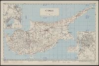
- Cyprus. Ktēmatologiko kai Chōrometriko Tmēma
- Published / Created:
- 1950
- Call Number:
- 509 1942
- Container / Volume:
- BRBL_00277
- Image Count:
- 1
- Resource Type:
- Maps, Atlases & Globes
- Found in:
- Beinecke Rare Book and Manuscript Library > Cyprus [cartographic material] / compiled by land Registration and Surveys, Cyprus.
- Creator:
- United States. Office of Coordinator of Information. Geographic Division
- Published / Created:
- [1941]
- Call Number:
- 354eb 1941
- Container / Volume:
- BRBL_00113
- Image Count:
- 1
- Resource Type:
- Maps, Atlases & Globes
- Found in:
- Beinecke Rare Book and Manuscript Library > Density of population (rural) / Geographic Div. - C.O.I.
- Creator:
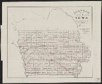
- United States. General Land Office
- Published / Created:
- 1866
- Call Number:
- 815fcm 1866
- Container / Volume:
- BRBL_00561
- Image Count:
- 1
- Resource Type:
- Maps, Atlases & Globes
- Found in:
- Beinecke Rare Book and Manuscript Library > Diagram of the public surveys in Iowa.
- Creator:
- United States. Department of State. Interim Research and Intelligence Service. Research and
- Published / Created:
- [1945]
- Call Number:
- 62f 1945
- Container / Volume:
- BRBL_00333
- Image Count:
- 1
- Resource Type:
- Maps, Atlases & Globes
- Found in:
- Beinecke Rare Book and Manuscript Library > Eritrea, Ethiopia, and Somaliland / R & A, IRIS.
- Published / Created:
- 1919
- Call Number:
- 30ed 1919A
- Container / Volume:
- BRBL_00037B
- Image Count:
- 1
- Resource Type:
- Maps, Atlases & Globes
- Found in:
- Beinecke Rare Book and Manuscript Library > Ethnographic Map of Europe.
- Published / Created:
- 1919
- Call Number:
- 30 1919A
- Container / Volume:
- BRBL_00032A
- Image Count:
- 4
- Resource Type:
- Maps, Atlases & Globes
- Found in:
- Beinecke Rare Book and Manuscript Library > Europe.
- Published / Created:
- 1919
- Call Number:
- 30 1919A
- Container / Volume:
- BRBL_00032A
- Image Count:
- 4
- Resource Type:
- Maps, Atlases & Globes
- Found in:
- Beinecke Rare Book and Manuscript Library > Europe.
- Published / Created:
- 1882
- Call Number:
- 771 F53 1882
- Container / Volume:
- BRBL_00482A
- Image Count:
- 1
- Resource Type:
- Maps, Atlases & Globes
- Found in:
- Beinecke Rare Book and Manuscript Library > Fisher's Island, New York / Surveyed by E. Hergesheimer, JE Hilgard, Supt.
- Published / Created:
- 1882
- Call Number:
- 771 F53 1882
- Container / Volume:
- BRBL_00482A
- Image Count:
- 1
- Resource Type:
- Maps, Atlases & Globes
- Found in:
- Beinecke Rare Book and Manuscript Library > Fisher's Island, New York / Surveyed by E. Hergesheimer, JE Hilgard, Supt.
- Creator:
- United States. Dept. of State
- Published / Created:
- 1947
- Call Number:
- 48g 1947
- Container / Volume:
- BRBL_00264
- Image Count:
- 1
- Resource Type:
- Maps, Atlases & Globes
- Found in:
- Beinecke Rare Book and Manuscript Library > Greece [cartographic material] : proposed works for water economy, 1:1 600 000.
- Creator:
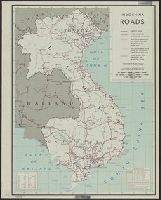
- United States. Office of Strategic Services
- Published / Created:
- 1945
- Call Number:
- 581gmb 1945
- Container / Volume:
- BRBL_00314
- Image Count:
- 1
- Resource Type:
- Maps, Atlases & Globes
- Found in:
- Beinecke Rare Book and Manuscript Library > Indochina roads.
- Creator:
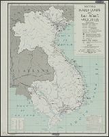
- United States. Office of Strategic Services. Research and Analysis Branch
- Published / Created:
- 1945
- Call Number:
- 581gme 1945
- Container / Volume:
- BRBL_00314
- Image Count:
- 1
- Resource Type:
- Maps, Atlases & Globes
- Found in:
- Beinecke Rare Book and Manuscript Library > Indochina, railroads and railroad facilities.
- Creator:
- United States. Department of State. Division of Map Intelligence and Cartography
- Published / Created:
- 1947
- Call Number:
- 57134 1947A
- Container / Volume:
- BRBL_00308
- Image Count:
- 1
- Resource Type:
- Maps, Atlases & Globes
- Found in:
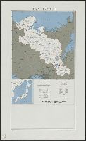
- Beinecke Rare Book and Manuscript Library > Japan : Kyoto-Fu.
- Creator:
- United States. Office of Strategic Services. Research and Analysis Branch
- Published / Created:
- 1945
- Call Number:
- 57gme 1945B
- Container / Volume:
- BRBL_00307
- Image Count:
- 1
- Resource Type:
- Maps, Atlases & Globes
- Found in:
- Beinecke Rare Book and Manuscript Library > Japan : railroads and railroad facilities.
- Creator:
- United States. Army Service Forces. Army Information Branch
- Published / Created:
- 1944
- Call Number:
- 57 1944
- Container / Volume:
- BRBL_00303
- Image Count:
- 1
- Resource Type:
- Maps, Atlases & Globes
- Found in:
- Beinecke Rare Book and Manuscript Library > Japan and adjacent regions / prepared and distributed by Army Information Branch, Army Service Forces.
- Published / Created:
- [1894?]
- Call Number:
- 556 1894
- Container / Volume:
- BRBL_00292
- Image Count:
- 1
- Resource Type:
- Maps, Atlases & Globes
- Found in:
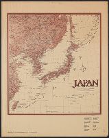
- Beinecke Rare Book and Manuscript Library > Korea, East China and Japan / The Norris Peters Co., photo-lith.
- Creator:
- United States. Office of Strategic Services. Research and Analysis Branch
- Published / Created:
- 1945
- Call Number:
- 277FB 1945
- Container / Volume:
- BRBL_00023D
- Image Count:
- 1
- Resource Type:
- Maps, Atlases & Globes
- Found in:
- Beinecke Rare Book and Manuscript Library > Lesser Sunda Islands administrative divisions / R & A, O.S.S.
- Published / Created:
- 1866
- Call Number:
- 75CKB 1870M
- Container / Volume:
- BRBL_00409
- Image Count:
- 1
- Resource Type:
- Maps, Atlases & Globes
- Found in:
- Beinecke Rare Book and Manuscript Library > Magnetic Declination : Isogonic lines for the year 1870 / Drawn by A. Lindenkohl ; Chas. G. Krebs, Lith.
- Creator:
- United States. Office of Strategic Services. Geography Division
- Published / Created:
- 1942
- Call Number:
- 60gm 1942
- Container / Volume:
- BRBL_00330
- Image Count:
- 1
- Resource Type:
- Maps, Atlases & Globes
- Found in:
- Beinecke Rare Book and Manuscript Library > Main transport facilities in central and south Africa / Compiled and drawn in Geography Division.
- Creator:
- United States. Office of Strategic Services. Research and Analysis Branch
- Published / Created:
- 1944
- Call Number:
- 583gm 1944A
- Container / Volume:
- BRBL_00314
- Image Count:
- 2
- Resource Type:
- Maps, Atlases & Globes
- Found in:
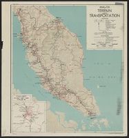
- Beinecke Rare Book and Manuscript Library > Malaya : terrain and transportation / compiled and drawn in the Branch of Research and Analysis, OSS.
- Creator:
- Geological Survey (U.S.)
- Published / Created:
- 1909
- Call Number:
- 844fcm Y83 1909
- Container / Volume:
- BRBL_00615
- Image Count:
- 1
- Resource Type:
- Maps, Atlases & Globes
- Found in:
- Beinecke Rare Book and Manuscript Library > Map of Yosemite Valley, Mariposa County, California / U.S. Geological Survey, George Otis Smith, Director ; E.M. Douglas, geographer ; State of California, George C. Pardee, Govenor.
- Creator:
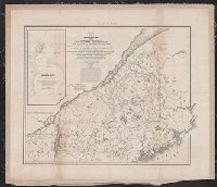
- United States. Army. Corps of Topographical Engineers
- Published / Created:
- 1843
- Call Number:
- 73fab 1843
- Container / Volume:
- BRBL_00375B
- Image Count:
- 1
- Resource Type:
- Maps, Atlases & Globes
- Found in:
- Beinecke Rare Book and Manuscript Library > Map of the boundary lines between the United States and the adjacent British provinces : from the mouth of the River St. Croix to the intersection of the parallel of 45 degrees of north latitude with the River St. Lawrence near St. Regis.
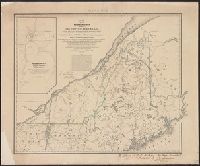
- Creator:
- United States. Army. Corps of Topographical Engineers
- Published / Created:
- 1843
- Call Number:
- 73fab 1843
- Container / Volume:
- BRBL_00375B
- Image Count:
- 1
- Resource Type:
- Maps, Atlases & Globes
- Found in:
- Beinecke Rare Book and Manuscript Library > Map of the boundary lines between the United States and the adjacent British provinces : from the mouth of the River St. Croix to the intersection of the parallel of 45 degrees of north latitude with the River St. Lawrence near St. Regis.
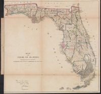
- Creator:
- United States. General Land Office
- Published / Created:
- 1866
- Call Number:
- 792 1866
- Container / Volume:
- BRBL_00518
- Image Count:
- 1
- Resource Type:
- Maps, Atlases & Globes
- Found in:
- Beinecke Rare Book and Manuscript Library > Map of the state of Florida : showing the progress of the surveys accompanying [the] annual report of [the] Commissioner.
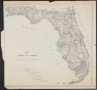
- Published / Created:
- 1860
- Call Number:
- 792 1860
- Container / Volume:
- BRBL_00518
- Image Count:
- 1
- Resource Type:
- Maps, Atlases & Globes
- Found in:
- Beinecke Rare Book and Manuscript Library > Map of the state of Florida showing the progress of the surveys accompanying annual report of the surveyor general for 1860.
- Creator:
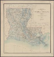
- O'Hare, Daniel
- Published / Created:
- 1896
- Call Number:
- 795 1896
- Container / Volume:
- BRBL_00521
- Image Count:
- 1
- Resource Type:
- Maps, Atlases & Globes
- Found in:
- Beinecke Rare Book and Manuscript Library > Map of the state of Louisiana / compiled from the official records of the General Land Office and other sources under the direction of Harry King ; revised and drawn by Daniel O'Hare.
- Creator:
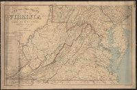
- Nicholson, W. L
- Published / Created:
- 1863
- Call Number:
- 783 1863B
- Container / Volume:
- BRBL_00509
- Image Count:
- 1
- Resource Type:
- Maps, Atlases & Globes
- Found in:
- Beinecke Rare Book and Manuscript Library > Map of the state of Virginia / compiled from the best authorities and printed at the Coast Survey Office, A.D. Bache, supdt. ; compiled by W.L. Nicholson ; lith. by Chas. G. Krebs.
- Creator:
- United States. Office of Strategic Services. Research and Analysis Branch
- Published / Created:
- 1945
- Call Number:
- 23ak M58 1945
- Container / Volume:
- BRBL_00021
- Image Count:
- 1
- Resource Type:
- Maps, Atlases & Globes
- Found in:
- Beinecke Rare Book and Manuscript Library > Micronesia : [outline maps] / R & A, OSS.
- Published / Created:
- 1913
- Call Number:
- 11hc 1913
- Container / Volume:
- BRBL_00010A
- Image Count:
- 1
- Resource Type:
- Maps, Atlases & Globes
- Found in:
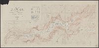
- Beinecke Rare Book and Manuscript Library > Mineral Production in the Caucasus / Authority: U.S. Geological Survey.
- Creator:
- United States. Bureau of the Census
- Published / Created:
- 1934
- Call Number:
- 831fb 1930
- Container / Volume:
- BRBL_00581
- Image Count:
- 1
- Resource Type:
- Maps, Atlases & Globes
- Found in:
- Beinecke Rare Book and Manuscript Library > Montana, minor civil divisions : 1930 / Bureau of the Census.
- Creator:
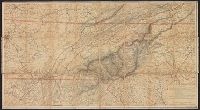
- Nicholson, W. L
- Published / Created:
- [1863]
- Call Number:
- 754 1863B
- Container / Volume:
- BRBL_00416
- Image Count:
- 1
- Resource Type:
- Maps, Atlases & Globes
- Found in:
- Beinecke Rare Book and Manuscript Library > Mountain region of North Carolina and Tennessee / compiled by W.L. Nicholson & A. Lindenkohl, 1863 ; drawn by A. Lindenkohl ; H. Lindenkohl & Chas. G. Krebs, lith.
- Creator:
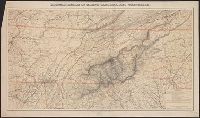
- Nicholson, W. L
- Published / Created:
- [1863]
- Call Number:
- 754 1863B
- Container / Volume:
- BRBL_00416
- Image Count:
- 1
- Resource Type:
- Maps, Atlases & Globes
- Found in:
- Beinecke Rare Book and Manuscript Library > Mountain region of North Carolina and Tennessee / compiled by W.L. Nicholson & A. Lindenkohl, 1863 ; drawn by A. Lindenkohl ; H. Lindenkohl & Chas. G. Krebs, lith.
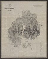
- Creator:
- U.S. Coast and Geodetic Survey
- Published / Created:
- 1875
- Call Number:
- 761 M86 1875
- Container / Volume:
- BRBL_00448
- Image Count:
- 1
- Resource Type:
- Maps, Atlases & Globes
- Found in:
- Beinecke Rare Book and Manuscript Library > Mt. Desert Island Maine / C.P Patterson, Superintendent ; verified, J.E. Hilgard, Assistant in Charge of Office ; topography surveyed by J.W. Donn.
- Published / Created:
- 1943
- Call Number:
- 40 N16 1943
- Container / Volume:
- BRBL_00212
- Image Count:
- 1
- Resource Type:
- Maps, Atlases & Globes
- Found in:
- Beinecke Rare Book and Manuscript Library > Naples Plan of Port.
- Creator:
- United States. Bureau of the Census
- Published / Created:
- 1934
- Call Number:
- 824fb 1930
- Container / Volume:
- BRBL_00572
- Image Count:
- 1
- Resource Type:
- Maps, Atlases & Globes
- Found in:
- Beinecke Rare Book and Manuscript Library > Nebraska, minor civil divisions : 1930 / Bureau of the Census.
- Creator:
- United States. Office of Strategic Services. Research and Analysis Branch
- Published / Created:
- [1945]
- Call Number:
- 5851 1945
- Container / Volume:
- BRBL_00315
- Image Count:
- 1
- Resource Type:
- Maps, Atlases & Globes
- Found in:
- Beinecke Rare Book and Manuscript Library > Political divisions of Malaya : Johore.
- Creator:
- United States. Office of Strategic Services. Research and Analysis Branch
- Published / Created:
- [1945]
- Call Number:
- 5852 1945
- Container / Volume:
- BRBL_00315
- Image Count:
- 1
- Resource Type:
- Maps, Atlases & Globes
- Found in:
- Beinecke Rare Book and Manuscript Library > Political divisions of Malaya Kedah and Perlis.
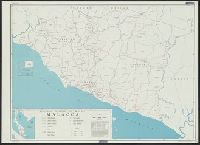
- Creator:
- United States. Office of Strategic Services. Research and Analysis Branch
- Published / Created:
- [1945]
- Call Number:
- 5856 1945A
- Container / Volume:
- BRBL_00315
- Image Count:
- 1
- Resource Type:
- Maps, Atlases & Globes
- Found in:
- Beinecke Rare Book and Manuscript Library > Political divisions of Malaya Malacca.
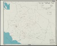
- Creator:
- United States. Office of Strategic Services. Research and Analysis Branch
- Published / Created:
- [1945]
- Call Number:
- 5843 1945
- Container / Volume:
- BRBL_00315
- Image Count:
- 1
- Resource Type:
- Maps, Atlases & Globes
- Found in:
- Beinecke Rare Book and Manuscript Library > Political divisions of Malaya Negri Sembilan.
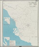
- Creator:
- United States. Office of Strategic Services. Research and Analysis Branch
- Published / Created:
- [1945]
- Call Number:
- 5842 1945
- Container / Volume:
- BRBL_00315
- Image Count:
- 1
- Resource Type:
- Maps, Atlases & Globes
- Found in:
- Beinecke Rare Book and Manuscript Library > Political divisions of Malaya Selangor.