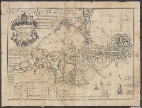
Search
You Searched For
Search Results
- Published / Created:
- [1833?]
- Call Number:
- 764 AM47 1833
- Container / Volume:
- BRBL_00453
- Image Count:
- 1
- Resource Type:
- Maps, Atlases & Globes
- Found in:
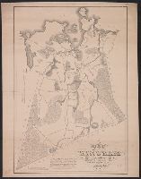
- Beinecke Rare Book and Manuscript Library > A Map of Amherst with a view of the College ... by Alonzo Gray & Charles B. Adams ... 1833.
- Published / Created:
- [1830?]
- Call Number:
- 764 H59 1830
- Container / Volume:
- BRBL_00457
- Image Count:
- 1
- Resource Type:
- Maps, Atlases & Globes
- Found in:
- Beinecke Rare Book and Manuscript Library > A Map of Hingham surveyed by Jedediah Lincon and Reuben hersey Jr. in 1830.
- Published / Created:
- 1831
- Call Number:
- 764 M52 1831
- Container / Volume:
- BRBL_00458
- Image Count:
- 1
- Resource Type:
- Maps, Atlases & Globes
- Found in:
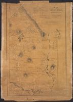
- Beinecke Rare Book and Manuscript Library > A Map of Mendon, Worcester County, Mass. By John Geo. Metcalf, M.D. Newell nelson, Surveyor.
- Published / Created:
- [1831?]
- Call Number:
- 764 B63 1831
- Container / Volume:
- BRBL_00454
- Image Count:
- 1
- Resource Type:
- Maps, Atlases & Globes
- Found in:
- Beinecke Rare Book and Manuscript Library > A Map of the Town of Bolton in the County of Worcester and the Commonwealth of Massachusetts. Surveyed by Silas Holman in the Year 1831.
- Published / Created:
- 1791
- Call Number:
- 7645cea 1791
- Container / Volume:
- BRBL_00463
- Image Count:
- 1
- Resource Type:
- Maps, Atlases & Globes
- Found in:
- Beinecke Rare Book and Manuscript Library > A chart of Nantucket Shoals by Capt. Paul Pinkham.
- Published / Created:
- [1840.]
- Call Number:
- 765CA 1840
- Container / Volume:
- BRBL_00464
- Image Count:
- 1
- Resource Type:
- Maps, Atlases & Globes
- Found in:
- Beinecke Rare Book and Manuscript Library > A geological map of Rhode-Island. By Charles T. Jackson. 1840.
- Creator:
- Burwell, Elliot Noël
- Published / Created:
- c1907.
- Call Number:
- 762 W73 1907
- Container / Volume:
- BRBL_00451
- Image Count:
- 1
- Resource Type:
- Maps, Atlases & Globes
- Found in:
- Beinecke Rare Book and Manuscript Library > A map of Lake Winnipesaukee, New Hampshire / author, Elliot Noël Burwell.
- Creator:
- Carleton, Osgood, 1742-1816
Doolittle, Amos, 1754-1832, engraver
Sullivan, James, 1744-1808. History of the district of Maine
Thomas & Andrews
- Published / Created:
- 1795
- Call Number:
- 1977 Folio 177
- Image Count:
- 2
- Resource Type:
- Maps, Atlases & Globes
- Found in:
- Beinecke Rare Book and Manuscript Library > A map of the district of Maine : drawn from the latest surveys and other best authorities / by Osgood Carleton ; Doolittle, sc., Newhaven.
- Published / Created:
- [1794?]
- Call Number:
- 764 1794
- Container / Volume:
- BRBL_00452
- Image Count:
- 1
- Resource Type:
- Maps, Atlases & Globes
- Found in:
- Beinecke Rare Book and Manuscript Library > A new map of Massachusetts State including Rhode Island and Connecticut .. revised by Osgood Carelton ... Boston.
- Published / Created:
- [1800?]
- Call Number:
- 764 1800
- Container / Volume:
- BRBL_00452
- Image Count:
- 1
- Resource Type:
- Maps, Atlases & Globes
- Found in:
- Beinecke Rare Book and Manuscript Library > A new map of the state of Massachusetts from the original map compiled by Osgood Carleton esqr. from the actual surveys that were made agreable to an act of the General court.
- Published / Created:
- 1800
- Call Number:
- 764 B65 1800
- Container / Volume:
- BRBL_00455
- Image Count:
- 1
- Resource Type:
- Maps, Atlases & Globes
- Found in:
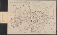
- Beinecke Rare Book and Manuscript Library > A new plan of Boston from Actual surveys by Osgood Carleton. With corrections, additions, & improvements.
- Creator:
- Price, William, fl. 1725-1769
- Published / Created:
- [1743]
- Call Number:
- 764 B65 1743
- Container / Volume:
- BRBL_00454
- Image Count:
- 1
- Resource Type:
- Maps, Atlases & Globes
- Found in:
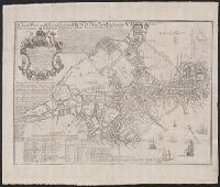
- Beinecke Rare Book and Manuscript Library > A new plan of ye great town of Boston in New England in America : with the many additionall buildings & new streets, to the year, 1743.
- Creator:
- Price, William, fl. 1725-1769
- Published / Created:
- [1743]
- Call Number:
- 764 B65 1743
- Container / Volume:
- BRBL_00454
- Image Count:
- 1
- Resource Type:
- Maps, Atlases & Globes
- Found in:
- Beinecke Rare Book and Manuscript Library > A new plan of ye great town of Boston in New England in America : with the many additionall buildings & new streets, to the year, 1743.
- Creator:
- Dearborn, Benjamin, 1754-1838
- Published / Created:
- [1814]
- Call Number:
- 764 B65 1814A
- Container / Volume:
- BRBL_00455
- Image Count:
- 2
- Resource Type:
- Maps, Atlases & Globes
- Found in:
- Beinecke Rare Book and Manuscript Library > A plan of those parts of Boston and the towns in its vicinity : with the waters and flats adjacent which are immediately or remotely connected with the contemplated design of erecting perpetual tide-mills.
- Creator:
- Hughes & Bailey
- Published / Created:
- [1919]
- Call Number:
- 766am Se96 1919
- Container / Volume:
- BRBL_00474
- Image Count:
- 1
- Resource Type:
- Maps, Atlases & Globes
- Found in:
- Beinecke Rare Book and Manuscript Library > Aero view of Seymour, Connecticut, 1919.
- Published / Created:
- [1795]
- Call Number:
- 761 1795
- Container / Volume:
- BRBL_00447
- Image Count:
- 2
- Resource Type:
- Maps, Atlases & Globes
- Found in:
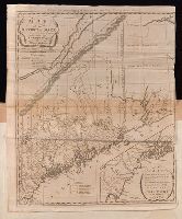
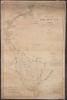
- Beinecke Rare Book and Manuscript Library > An accurate Map of the District of Maine Being part of the Commonwealth of Massachusetts ...
- Published / Created:
- [1833?]
- Call Number:
- 762 1833
- Container / Volume:
- BRBL_00450
- Image Count:
- 1
- Resource Type:
- Maps, Atlases & Globes
- Found in:
- Beinecke Rare Book and Manuscript Library > An improved reference to distance map of New Hampshire ...
- Published / Created:
- 1831
- Call Number:
- 501 AR54 1831
- Container / Volume:
- BRBL_00276
- Image Count:
- 1
- Resource Type:
- Maps, Atlases & Globes
- Found in:
- Beinecke Rare Book and Manuscript Library > Armenia and the Adjacent Countries.
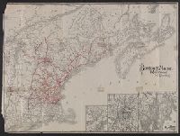
- Creator:
- Rand Avery Supply Co
- Published / Created:
- [1911?]
- Call Number:
- 76gme 1910
- Container / Volume:
- BRBL_00446A
- Image Count:
- 1
- Resource Type:
- Maps, Atlases & Globes
- Found in:
- Beinecke Rare Book and Manuscript Library > Boston & Maine Railroad and connections / Rand Avery Supply Co.
- Published / Created:
- 1918
- Call Number:
- 764gme B65 1918
- Container / Volume:
- BRBL_00462
- Image Count:
- 1
- Resource Type:
- Maps, Atlases & Globes
- Found in:
- Beinecke Rare Book and Manuscript Library > Boston Subway, East Boston Tunnel, Washington St. Tunnel, tunnel for Cambridge connection, Dorchester Tunnel, Boylston St. Subway & East Boston Tunnel Connection.
- Published / Created:
- 1897
- Call Number:
- 764 M64 1897
- Container / Volume:
- BRBL_00458
- Image Count:
- 1
- Resource Type:
- Maps, Atlases & Globes
- Found in:
- Beinecke Rare Book and Manuscript Library > Breck's map of Milton : showing area taken for the Blue Hills Reservation of the Metropolitan Park System, also location of fire alarm boxes and police signal stations / Chas. C.E. Breck, Civil Engr.
- Published / Created:
- 1875
- Call Number:
- 764hc B65 1775
- Container / Volume:
- BRBL_00462
- Image Count:
- 2
- Resource Type:
- Maps, Atlases & Globes
- Found in:
- Beinecke Rare Book and Manuscript Library > Bunker Hill Centennial.
- Creator:
- E.P. Dutton (Firm)
- Published / Created:
- 1865
- Call Number:
- 764 B65 1865
- Container / Volume:
- BRBL_00455
- Image Count:
- 1
- Resource Type:
- Maps, Atlases & Globes
- Found in:
- Beinecke Rare Book and Manuscript Library > Chart of Boston Harbor and Massachusetts Bay : with map of the adjacent country / published at the Boston Map Store.
- Published / Created:
- [1820?]
- Call Number:
- 49cea 1820
- Container / Volume:
- BRBL_00268
- Image Count:
- 1
- Resource Type:
- Maps, Atlases & Globes
- Found in:
- Beinecke Rare Book and Manuscript Library > Chart of the Black Sea, the Sea of Azop, the Sea of Marmora, the Archipelago and a part of the Mediterranean. Engraved by Annen & Smith, Boston.
- Creator:
- Hill, A. B
- Published / Created:
- c1896.
- Call Number:
- 766 N46 1896A
- Container / Volume:
- BRBL_00473
- Image Count:
- 1
- Resource Type:
- Maps, Atlases & Globes
- Found in:
- Beinecke Rare Book and Manuscript Library > City of New Haven, Connecticut / A.B. Hill ; engraved by Geo. H. Walker & Co.
- Creator:
- Hill, A. B., civil engineer
- Published / Created:
- c1893.
- Call Number:
- 766 N46 1893J
- Container / Volume:
- BRBL_00473
- Image Count:
- 1
- Resource Type:
- Maps, Atlases & Globes
- Found in:
- Beinecke Rare Book and Manuscript Library > City of New Haven, Connecticut / A.B. Hill, c.e.
- Creator:
- Geo. H. Walker & Co
- Published / Created:
- c1904.
- Call Number:
- 764gmb T193 1904
- Container / Volume:
- BRBL_00462
- Image Count:
- 1
- Resource Type:
- Maps, Atlases & Globes
- Found in:
- Beinecke Rare Book and Manuscript Library > City of Taunton.
- Creator:
- Perkins, Frederic B. (Frederic Beecher), 1828-1899
- Published / Created:
- 1880
- Call Number:
- 75FCB 1880G
- Container / Volume:
- BRBL_00410
- Image Count:
- 1
- Resource Type:
- Maps, Atlases & Globes
- Found in:
- Beinecke Rare Book and Manuscript Library > Congressional district vote map of the United States / designed by Fred B. Perkins ; drawn by Whitman & Breck.
- Published / Created:
- 1842
- Call Number:
- 766 1842A
- Container / Volume:
- BRBL_00466
- Image Count:
- 1
- Resource Type:
- Maps, Atlases & Globes
- Found in:
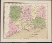
- Beinecke Rare Book and Manuscript Library > Connecticut.
- Published / Created:
- 1838
- Call Number:
- 766 1838
- Container / Volume:
- BRBL_00466
- Image Count:
- 1
- Resource Type:
- Maps, Atlases & Globes
- Found in:
- Beinecke Rare Book and Manuscript Library > Connecticut.
- Published / Created:
- 1893
- Call Number:
- 776cea 1893
- Container / Volume:
- BRBL_00502
- Image Count:
- 1
- Resource Type:
- Maps, Atlases & Globes
- Found in:
- Beinecke Rare Book and Manuscript Library > Eldridge's Chart No. 11 : Delaware Bay and river / from the U.S. Coast and George Elridge's surveys.
- Published / Created:
- 1893
- Call Number:
- 766 F16 1893
- Container / Volume:
- BRBL_00468
- Image Count:
- 1
- Resource Type:
- Maps, Atlases & Globes
- Found in:
- Beinecke Rare Book and Manuscript Library > Fairfield [County].
- Published / Created:
- [1833?]
- Call Number:
- 764CA 1833
- Container / Volume:
- BRBL_00460
- Image Count:
- 1
- Resource Type:
- Maps, Atlases & Globes
- Found in:
- Beinecke Rare Book and Manuscript Library > Geological map of Massachusetts By Edw. D. Hitchcock 1833 ...
- Published / Created:
- 1863
- Call Number:
- 774AM G33 1863
- Container / Volume:
- BRBL_00500
- Image Count:
- 1
- Resource Type:
- Maps, Atlases & Globes
- Found in:
- Beinecke Rare Book and Manuscript Library > Gettysburg Battlefield : Battle fought at Gettyburg Pa. on July 1st 2d 3d byt the Federal and Confederate armies.
- Creator:
- Goldthwait, J. H.
- Published / Created:
- [1843]
- Call Number:
- BrSides 2019 109
- Image Count:
- 2
- Resource Type:
- Maps, Atlases & Globes
- Found in:
- Beinecke Rare Book and Manuscript Library > Goodyear's miniature county map of the United States / engraved by J.H. Goldthwait.
- Creator:
- Hovey, Horace Carter, 1833-1914
- Published / Created:
- 1907
- Call Number:
- 802 M31 1907
- Container / Volume:
- BRBL_00542
- Image Count:
- 1
- Resource Type:
- Maps, Atlases & Globes
- Found in:
- Beinecke Rare Book and Manuscript Library > Guide map of the Mammoth Cave, Kentucky / drawn by Horace C. Hovey.
- Published / Created:
- 1893
- Call Number:
- 766 H26 1893
- Container / Volume:
- BRBL_00468
- Image Count:
- 1
- Resource Type:
- Maps, Atlases & Globes
- Found in:
- Beinecke Rare Book and Manuscript Library > Hartford [County].
- Published / Created:
- 1893
- Call Number:
- 766 1893J
- Container / Volume:
- BRBL_00467
- Image Count:
- 2
- Resource Type:
- Maps, Atlases & Globes
- Found in:
- Beinecke Rare Book and Manuscript Library > Latest map and index of Connecticut.
- Published / Created:
- 1893
- Call Number:
- 766 1893W
- Container / Volume:
- BRBL_00467
- Image Count:
- 1
- Resource Type:
- Maps, Atlases & Globes
- Found in:
- Beinecke Rare Book and Manuscript Library > Latest map and index of Eastern Connecticut.
- Creator:
- Searl, A. D
- Published / Created:
- [1854]
- Call Number:
- 825gmb L435 1854
- Container / Volume:
- BRBL_00576
- Image Count:
- 1
- Resource Type:
- Maps, Atlases & Globes
- Found in:
- Beinecke Rare Book and Manuscript Library > Lawrence City, Kanzas Territory / surveyed Oct. 1854 by A.D. Searl.
- Creator:
- Leavitt, Franklin, 1824-
- Published / Created:
- 1859
- Call Number:
- 762AM W588 1859
- Container / Volume:
- BRBL_00451
- Image Count:
- 1
- Resource Type:
- Maps, Atlases & Globes
- Found in:
- Beinecke Rare Book and Manuscript Library > Leavitt's map with views of the White Mountains, New Hampshire ; 1859 / drawn by Franklin Leavitt, Lancaster, N.H.
- Published / Created:
- 1893
- Call Number:
- 766 L71 1893
- Container / Volume:
- BRBL_00469
- Image Count:
- 1
- Resource Type:
- Maps, Atlases & Globes
- Found in:
- Beinecke Rare Book and Manuscript Library > Litchfield County.
- Creator:
- Coolidge, A. J. (Austin Jacobs)
- Published / Created:
- 1859
- Call Number:
- 761 1859
- Container / Volume:
- BRBL_00447
- Image Count:
- 1
- Resource Type:
- Maps, Atlases & Globes
- Found in:
- Beinecke Rare Book and Manuscript Library > Maine 1859.
- Published / Created:
- 1830
- Call Number:
- 764 AB58 1830
- Container / Volume:
- BRBL_00453
- Image Count:
- 1
- Resource Type:
- Maps, Atlases & Globes
- Found in:
- Beinecke Rare Book and Manuscript Library > Map of Abington, Mass. surveyed by James Bates.
- Creator:
- Boston and Bangor Steamship Company
- Published / Created:
- [1889?]
- Call Number:
- 761 M86 1889
- Container / Volume:
- BRBL_00448
- Image Count:
- 2
- Resource Type:
- Maps, Atlases & Globes
- Found in:
- Beinecke Rare Book and Manuscript Library > Map of Boston & Bangor Steamship Co. showing approaches to Mount Desert.
- Published / Created:
- 1819
- Call Number:
- 764 B65 1819
- Container / Volume:
- BRBL_00455
- Image Count:
- 1
- Resource Type:
- Maps, Atlases & Globes
- Found in:
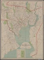
- Beinecke Rare Book and Manuscript Library > Map of Boston and its Vicinity by John G. Hales.
- Creator:
- Walling, Henry Francis, 1825-1888
- Published / Created:
- 1869
- Call Number:
- 764 B65 1869
- Container / Volume:
- BRBL_00455
- Image Count:
- 1
- Resource Type:
- Maps, Atlases & Globes
- Found in:
- Beinecke Rare Book and Manuscript Library > Map of Boston and the country adjacent, from actual surveys / by H.F. Walling.
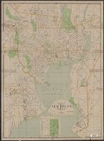
- Creator:
- Sampson, Murdock & Co
- Published / Created:
- [1886], c1885.
- Call Number:
- 764 B65 1886
- Container / Volume:
- BRBL_00456
- Image Count:
- 1
- Resource Type:
- Maps, Atlases & Globes
- Found in:
- Beinecke Rare Book and Manuscript Library > Map of Boston for 1886.
- Creator:
- Walker Lith. & Pub. Co
- Published / Created:
- 1909
- Call Number:
- 764 B65 1909
- Container / Volume:
- BRBL_00456
- Image Count:
- 1
- Resource Type:
- Maps, Atlases & Globes
- Found in:
- Beinecke Rare Book and Manuscript Library > Map of Boston proper.