
You Searched For
1 - 4 of 4
Search Results
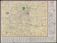
- Creator:
- Rand McNally and Company
- Published / Created:
- [1942].
- Call Number:
- 834gmb 1942
- Container / Volume:
- BRBL_00591
- Image Count:
- 2
- Resource Type:
- Maps, Atlases & Globes
- Alternative Title:
- Sectional trip map., Texaco sectional trip map., Texaco touring map of Colorado., and Touring map of Colorado.
- Description:
- "X 3805" in lower right of Colorado map and "X.4113(N)" in lower right of Sectional trip map., Includes index, 4 local route maps, distance table, and text., Panel title., Relief shown pictorially and by spot heights., and Texaco touring map of Colorado -- Texaco
- Publisher:
- Rand McNally and Co.,
- Subject (Geographic):
- Colorado--Maps
- Subject (Name):
- Texas Company
- Subject (Topic):
- Roads--Colorado--Maps and Roads--West (U.S.)--Maps
- Found in:
- Beinecke Rare Book and Manuscript Library > Colorado : with sectional map of adjoining states / [prepared for] Texaco.
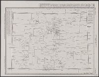
- Creator:
- H.M. Gousha Company
- Published / Created:
- [1935].
- Call Number:
- 834gmb 1935
- Container / Volume:
- BRBL_00591
- Image Count:
- 2
- Resource Type:
- Maps, Atlases & Globes
- Alternative Title:
- Colorado, Conoco official road map, Colorado, and Travel Colorado with Conoco
- Description:
- "1-6-5" in lower right of Colorado map, "I(?)-422 J.C." in U.S. map, and "I" in Denver map., "Official road map, United States," map of "Denver, Colorado," and ill. on verso., Conoco logo at head of title., Indexed., and Relief shown by hachures and spot heights.
- Publisher:
- H.M. Gousha,
- Subject (Geographic):
- Colorado--Maps
- Subject (Topic):
- Roads--Colorado--Maps and Roads--United States--Maps
- Found in:
- Beinecke Rare Book and Manuscript Library > Official road map, Colorado / Conoco Travel Bureau.
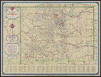
- Creator:
- H.M. Gousha Company
- Published / Created:
- [1937]
- Call Number:
- 834gmb 1937
- Container / Volume:
- BRBL_00591
- Image Count:
- 2
- Resource Type:
- Maps, Atlases & Globes
- Alternative Title:
- Colorado, Shell official road map, Colorado, and Shell road map, Colorado
- Description:
- "341-J.C." and "9-K.", Indexed., Maps of "Rocky Mountain National Park," "Denver Mountain Parks," and "Colorado Springs, Pikes Peak region," distance table, and radio log on verso., Relief shown by hachures and spot heights., and Shell logo at head of title.
- Publisher:
- H.M. Gousha,
- Subject (Geographic):
- Colorado--Maps
- Subject (Topic):
- Roads--Colorado--Maps
- Found in:
- Beinecke Rare Book and Manuscript Library > Official road map, Colorado / [prepared for] Shell.