Skip to search
Skip to main content
Skip to first result
Search
You Searched For
Access
Public
Format
cartographic
Publication Place
Chicago
New Search
Search Results
Creator:
Published / Created:
undated
Call Number:
Zc18 A11 856db
Image Count:
2
Resource Type:
Books, Journals & Pamphlets
Abstract:
Shows railroad routes operated by various companies in Ohio, Ind., Ill., and portions of Ont., N.Y., Pa., Md., W. Va., Ky., Mo., Iowa, Wis., and Mich.
Alternative Title:
Great western railway guide
Publisher:
D.B. Cooke & Co., 1856 (Cincinnati : Middleton, Wallace & Co. Lith.)
Subject (Topic):
Railroads
Found in:
Beinecke Rare Book and Manuscript Library > D.B. Cooke & Cos great western railway guide : exhibiting all stations with distances from each other.
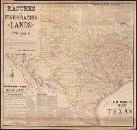
Creator:
Published / Created:
[1887]
Call Number:
BrSides Elephant Folio Zc52 887ra
Image Count:
1
Resource Type:
Maps, Atlases & Globes
Alternative Title:
Map of the state of Texas.
Description:
Coordinates not present on map and are approximated., Imperfect: Mutilated at upper right, with some loss of text. Mounted on linen., Includes facts and figures about Texas and information about land for sale by E. M. Powell., and Relief shown by hachures.
Publisher:
Rand, McNally & Co.
Subject (Geographic):
Texas--Maps
Subject (Name):
Powell, E. M. (Ernest Malapert)
Found in:
Beinecke Rare Book and Manuscript Library > E.M. Powell's map of the state of Texas.
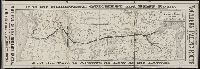
Creator:
Published / Created:
1879
Call Number:
BrSides Zc19 N82k 879it
Image Count:
2
Resource Type:
Maps, Atlases & Globes
Abstract:
Leaflet advertising the Northern Pacifics route from Minneapolis to the Pacific Northwest, including schedules of trains, land for sale, and connecting stagecoaches.
Publisher:
Rand, McNally & Co., Printers
Subject (Name):
Northern Pacific Railroad Company
Subject (Topic):
Dakota Territory., Montana., Washington (State), and West (U.S.)
Found in:
Beinecke Rare Book and Manuscript Library > It is the shortest, quickest and best route : and the fare is always as low as the lowest
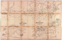
Creator:
Published / Created:
[between 1912 and 1920?]
Call Number:
BrSides Box 2013 83
Image Count:
2
Resource Type:
Maps, Atlases & Globes
Description:
From the library of Madam C.J. Walker.
Publisher:
Idlewild Resort Co.
Subject (Geographic):
Idlewild (Mich.)--Maps
Subject (Name):
Walker, C. J., Madam, 1867-1919--Ownership
Found in:
Beinecke Rare Book and Manuscript Library > Map of Idlewild, Lake Co., Mich.
Published / Created:
[n.d.]
Call Number:
Cc5 5 2.1
Image Count:
1
Description:
Various scales.
Publisher:
Lith. by Ed. Mendel
Subject (Geographic):
Rock Island (Ill.)
Found in:
Beinecke Rare Book and Manuscript Library > Map showing the relative position of Rock Island, with the North Western states and territories
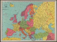
Creator:
Published / Created:
[n.d.]
Call Number:
30 1920E
Container / Volume:
BRBL_00032A
Image Count:
2
Resource Type:
Maps, Atlases & Globes
Description:
On verso: Europe in 1921, with railways. - Western fron. - Section of Maginot line fortification. - Europe air mileage distances. - Unification of Germany, 1866-1871. - Text., Shows 1914 boundarie, and Title on cover when folded: Rand McNally war map of Europe.
Subject (Geographic):
Europe--Maps
Subject (Topic):
World War, 1914-1918--Maps
Found in:
Beinecke Rare Book and Manuscript Library > Rand McNally standard map of Europe.
Branch:v1.61.6 ,Deployed:2024-06-12T09:55:36-04:00