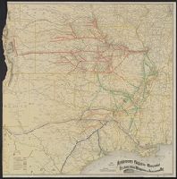
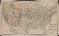
Colton, G. Woolworth (George Woolworth), 1827-1901
Published / Created:
1862
Call Number:
754gme 1860A
Container / Volume:
BRBL_00420
Image Count:
1
Resource Type:
Maps, Atlases & Globes
Alternative Title:
map of Wisconsin, Illinois, Missouri
Description:
"Entered according to Act of Congress by Thayer & Colton in the Clerk's office of the District Court of the United States for the Southern District of New York in t and Does not include northern half of Wisconsin; Appleton is the northernmost town on the map.
Publisher:
Drawn, engraved & published by G. Woolworth Colton; and Rufus Blanchard,
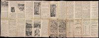
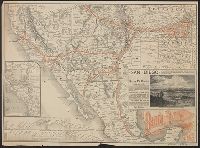
Santa Fé route : and Santa Fé route to the city of Mexico by the Atchison, Topeka and Santa Fé R.R. and Mexican Central R.R.
Description:
"February" on panel and "November 29, 1885" on timetable., Covers southweste, Relief shown by hachures., Shows cities and towns, stations, Indian reservations, state boundaries, and the railroad network emphasizing the main line., and Text and timetable on verso.
Publisher:
Rand, McNally,
Subject (Name):
Atchison, Topeka, and Santa Fe Railroad Company, Atchison, Topeka, and Santa Fe Railroad Company--Maps, Mexican Central Railway Co, and Mexican Central Railway Co.--Maps
Subject (Topic):
Railroads--Mexico--Maps, Railroads--Mexico--Timetables, Railroads--Southwestern States--Maps, and Railroads--Southwestern States--Timetables