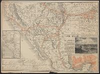
Philadelphia and vicinity [cartographic material]. and Rand McNally & Co.'s map showing one hundred miles around Philadelphia.
Description:
Inset map on recto: Philadelphia and vicinity. Scale [ca. 1:116 000]., Map on verso: Rand McNally & Co.'s map showing one hundred miles around Philadelphia. Scale [ca. 1:506 880]. Eight miles to one inc, and Sheet measures 54 x 72 cm. Ms. no. on verso: Egk76 2.
Publisher:
Rand, McNally & Co.,
Subject (Geographic):
Middle Atlantic States--Maps, Philadelphia (Pa.)--Maps, and Philadelphia Metropolitan Area (Pa.)--Maps
Imperfect: Mutilated, with some loss of text. Sheet measures 71 x 54 cm., In lower left corner: Rand, McNally & Co.'s indexed atlas of the world map of Italy, copyright, 1898 ..., In lower right corner: 1912., and Relief shown by hachures and spot heig
Santa Fé route : and Santa Fé route to the city of Mexico by the Atchison, Topeka and Santa Fé R.R. and Mexican Central R.R.
Description:
"February" on panel and "November 29, 1885" on timetable., Covers southweste, Relief shown by hachures., Shows cities and towns, stations, Indian reservations, state boundaries, and the railroad network emphasizing the main line., and Text and timetable on verso.
Publisher:
Rand, McNally,
Subject (Name):
Atchison, Topeka, and Santa Fe Railroad Company, Atchison, Topeka, and Santa Fe Railroad Company--Maps, Mexican Central Railway Co, and Mexican Central Railway Co.--Maps
Subject (Topic):
Railroads--Mexico--Maps, Railroads--Mexico--Timetables, Railroads--Southwestern States--Maps, and Railroads--Southwestern States--Timetables
1920-1929, Bound with index, lacking advertisements and wrappers of individual issues., Edited by F.F. Browne, W.R. Browne, S. Thayer, Marianne Moore and others., Monthly,, Title from caption., and Vol. 1, no. 1 (May 1880)-v. 86, no. 7 (July 1929).
Publisher:
Jansen, McClurg,
Subject (Name):
Lewis, Wyndham, 1882-1957 and Quinn, John, 1870-1924