Search
You Searched For
Search Results
- Published / Created:
- Aug. 25, 1888.
- Call Number:
- Print10207
- Image Count:
- 1
- Resource Type:
- still image
- Found in:
- Medical Historical Library, Cushing/Whitney Medical Library > "What are the wild waves saying?" Try Beecham's Pills. [graphic]
- Creator:
- Russell, John, fl. 1733-1795
- Published / Created:
- 1794 July 26
- Call Number:
- 1986 102
- Collection Title:
- An historical, geographical, commercial, and philosophical view of the American United States, and
- Image Count:
- 1
- Found in:
- Beinecke Rare Book and Manuscript Library > A General map of North America drawn from the best sources
- Published / Created:
- 1776
- Call Number:
- Cb23 27
- Collection Title:
- The American military pocket atlas : being an approved collection of correct maps, both general and
- Image Count:
- 1
- Found in:
- Beinecke Rare Book and Manuscript Library > A General map of the northern British colonies in America. which comprehends the province of Quebec, the government of Newfoundland, Nova-Scotia, New-England and New-York. From the maps published by the Admiralty and Board of Trade regulated by the astronomic and trigonometric observations of M. von Holland and corrected from Governor Pownall's late map 1776.
- Creator:
- Romans, B
- Published / Created:
- 1776
- Call Number:
- Cb23 27
- Collection Title:
- The American military pocket atlas : being an approved collection of correct maps, both general and
- Image Count:
- 1
- Found in:
- Beinecke Rare Book and Manuscript Library > A General map of the southern British colonies, in America, comprehending North and South Carolina, Georgia, east and west Florida, with the neighbouring Indian countries. From the modern surveys of engineer de Brahm, Capt. Collet, Mouzon & others; and from the large hydrographical survey of the coasts of east and west Florida
- Creator:
- Brasier, William
- Published / Created:
- 1776
- Call Number:
- Cb23 27
- Collection Title:
- The American military pocket atlas : being an approved collection of correct maps, both general and
- Image Count:
- 1
- Found in:
- Beinecke Rare Book and Manuscript Library > A Survey of Lake Champlain, including Lake George, Crown Point and St. John. Surveyed by order of His Excellency Major General Sr. Jeffery Amherst, knight of the most honble. Order of the Bath, Commander in Chief of His Majesty's forces in North America (now Lord Amherst) by William Brassier, draughtsman, 1762
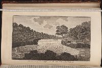
- Published / Created:
- 1795
- Call Number:
- 1986 102
- Collection Title:
- An historical, geographical, commercial, and philosophical view of the American United States, and
- Image Count:
- 1
- Found in:
- Beinecke Rare Book and Manuscript Library > A View of Ohiopyle Falls in Pennsylvania
- Creator:
- Delarochette, L. (Louis), 1731-1802, creator
Faden, William, 1749-1836
Palmer, William, 1750-1836
- Published / Created:
- 1784 March 1
- Call Number:
- 1982 Folio 10
- Image Count:
- 1
- Found in:
- Beinecke Rare Book and Manuscript Library > A chart of the Antilles, or, Charibbee, or, Caribs Islands, with the Virgin Isles
- Creator:
- Delarochette, L. (Louis), 1731-1802
Dicquemare, (Jacques-Francois), M. l'abbe, 1733-1789, creator
Faden, William, 1749-1836
- Published / Created:
- 1780 June 17
- Call Number:
- 1982 Folio 10
- Image Count:
- 1
- Found in:
- Beinecke Rare Book and Manuscript Library > A chart of the British Channel and the Bay of Biscay with a part of the North Sea, and the entrance of St. George's Channel
- Creator:
- Delarochette, L. (Louis), 1731-1802, creator
- Published / Created:
- 1780 June 28
- Call Number:
- 1982 Folio 10
- Image Count:
- 1
- Found in:
- Beinecke Rare Book and Manuscript Library > A chart of the coasts of Spain and Portugal, with the Balearic Islands, and part of the coast of Barbary
- Creator:
- Delarochette, L. (Louis), 1731-1802, creator
- Published / Created:
- 1781 January 1
- Call Number:
- 1982 Folio 10
- Image Count:
- 1
- Found in:
- Beinecke Rare Book and Manuscript Library > A chart of the islands of Jersey and Guernsey, Sark, Herm and Alderney, with the adjacent coast of France
- Creator:
- Wilson, George, b. 1631 or 2
- Published / Created:
- 1698
- Call Number:
- QD27 W54 1698
- Image Count:
- 202
- Found in:
- Beinecke Rare Book and Manuscript Library > A compleat course of chymistry : containing near three hundred operations, several of which have not been publish’d before : also the structure of several furnaces, with near three hundred characters, which are dispers’d in chymical authors, and such instruments and vessels as are necessary in a compleat elaboratory : all cut in copper / by George Wilson
- Creator:
- Vaughan, Robert, 17th cent., engraver
- Published / Created:
- 1624
- Call Number:
- 2003 +39
- Collection Title:
- The generall historie of Virginia, New-England, and the Summer Iles ...
- Image Count:
- 1
- Found in:
- Beinecke Rare Book and Manuscript Library > A description of part of the adventures of Cap. Smith in Virginia
- Creator:
- Vaughan, Robert, 17th cent., engraver
- Published / Created:
- 1624
- Call Number:
- Pequot +Sm4
- Collection Title:
- The generall historie of Virginia, New-England, and the Summer Isles : with the names of the
- Image Count:
- 1
- Found in:
- Beinecke Rare Book and Manuscript Library > A description of part of the adventures of Cap. Smith in Virginia
- Published / Created:
- 1776
- Call Number:
- Cb23 27
- Collection Title:
- The American military pocket atlas : being an approved collection of correct maps, both general and
- Image Count:
- 1
- Found in:
- Beinecke Rare Book and Manuscript Library > A general map of the middle British colonies in America. Containing Virginia, Maryland, the Delaware counties, Pennsylvania and New Jersey. With the addition of New York, and of the greatest part of New England, as also of the bordering parts of the province of Quebec, improved from several surveys made after the late war, and corrected from Governor Pownall's late map 1776.
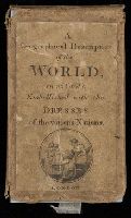
- Published / Created:
- [1815?]
- Call Number:
- PLAYING CARDS GEN 397
- Image Count:
- 35
- Resource Type:
- text and still image
- Found in:
- Beinecke Rare Book and Manuscript Library > A geographical description of the world : on 32 cards ; embellished with the dresses of the various nations
- Creator:
- Faden, William, 1749-1836
Rennell, James, 1742-1830, creator
- Published / Created:
- 1786 January 1
- Call Number:
- 1982 Folio 10
- Image Count:
- 1
- Found in:
- Beinecke Rare Book and Manuscript Library > A map of Bengal, Bahar, Oude & Allahabad with part of Agra and Delhi : exhibiting the course of the Ganges from Hurdwar to the sea
- Creator:
- Anville, Jean Baptiste Bourguignon d', 1697-1782
Kitchin, Thomas, d. 1784
Sayer, Robert, 1725-1794, creator
- Published / Created:
- 1787 July 1
- Call Number:
- 1982 Folio 10
- Image Count:
- 2
- Found in:
- Beinecke Rare Book and Manuscript Library > A map of South America : containing Tierra-Firma, Guayana, New Granada, Amazonia, Brasil, Peru, Paraguay, Chaco, Tucuman, Chili and Patagonia : from Mr. d'Anville with several improvements and additions, and the newest discoveries
- Creator:
- Faden, William, 1749-1836, creator
- Published / Created:
- 1789 January 1
- Call Number:
- 1982 Folio 10
- Image Count:
- 1
- Found in:
- Beinecke Rare Book and Manuscript Library > A map of the Austrian possessions in the Netherlands or Low Countries, with the principalities of Liege and Stavelo, & ca : reduced from the trigonometric survey made by order of H.R.H. the Prince Charles of Lorraine
- Creator:
- Faden, William, 1749-1836, creator
- Published / Created:
- 1785 March 1
- Call Number:
- 1982 Folio 10
- Image Count:
- 2
- Found in:
- Beinecke Rare Book and Manuscript Library > A map of the Mediterranean Sea, with the adjacent regions and seas in Europe, Asia, and Africa
- Creator:
- Faden, William, 1749-1836, creator
- Published / Created:
- 1789 January 1
- Call Number:
- 1982 Folio 10
- Image Count:
- 1
- Found in:
- Beinecke Rare Book and Manuscript Library > A map of the seven united provinces, with the land of Drent, and the generality Lands