Search
You Searched For
Search Results
- Creator:
- Faden, William, 1749-1836
- Published / Created:
- March 1st 1785.
- Call Number:
- 49 1785
- Container / Volume:
- BRBL_00267
- Image Count:
- 2
- Resource Type:
- Maps, Atlases & Globes
- Found in:
- Beinecke Rare Book and Manuscript Library > A map of the Mediterranean Sea, with the adjacent regions and seas in Europe, Asia, and Africa / by William Faden.
- Creator:
- Faden, William, 1749-1836
- Published / Created:
- Octr. 19th, 1776.
- Call Number:
- 771 N49 1776K
- Container / Volume:
- BRBL_00484
- Image Count:
- 1
- Resource Type:
- Maps, Atlases & Globes
- Found in:
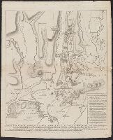
- Beinecke Rare Book and Manuscript Library > A plan of New York Island, with part of Long Island, Staten Island & east New Jersey : with a particular description of the engagement on the woody heights of Long Island, between Flatbush and Brooklyn, on the 27th of August 1776 between His Majesty's for
- Creator:
- Faden, William, 1749-1836
Palmer, W. (William), 1739-1812
Roberts, Henry, Lieut
- Published / Created:
- 1784
- Call Number:
- 23 1784
- Container / Volume:
- BRBL_00019
- Image Count:
- 1
- Resource Type:
- Maps, Atlases & Globes
- Found in:
- Beinecke Rare Book and Manuscript Library > Chart of the N.W. coast of America and the N.E. coast of Asia, explored in the years 1778 and 1779 / prepared by Lieut. Heny. Roberts, under the immediate inspection of Capt. Cook ; engraved by W. Palmer.