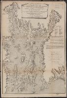
According to Kershaw this map is the second state., From: The English pilot, the fourth book, published between 1732 and 1749., and Map is showing shoals and depth is shown by soundings.
Publisher:
Sold by Willm. Mount & Tho. Page at the Postern on Great Tower Hill,
Subject (Geographic):
Atlantic Coast (North America)--Maps--Early works to 1800
Subject (Name):
Mount, William, d. 1769, bookseller and Page, Thomas, d. 1733, bookseller
Subject (Topic):
Nautical charts--Atlantic Coast (North America)--Early works to 1800
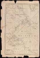
From: Vancouver's A voyage of discovery to the North Pacific Ocean and round the world. London, 1798., In top right margin: 5., Insets: Entrance of Columbia River -- Gray's Harbour -- Port Discovery., and Relief shown pictorially and by hachures. Depths shown by soundings.
Publisher:
J. Edwards & G. Robinson,
Subject (Geographic):
British Columbia--Maps--Early works to 1800 and Washington (State)--Maps--Early works to 1800
Subject (Name):
Arnold, Robert M.--Ownership, Baker, Joseph, 1768-1817, Edwards, James, 1757-1816, Robinson, G. G. (George G.), and Vancouver, George, 1757-1798. Voyage of discovery to the North Pacific Ocean and round the world. 1
Subject (Topic):
Coasts--British Columbia--Maps--Early works to 1800 and Coasts--Washington (State)--Maps--Early works to 1800
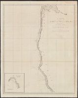
From: Vancouver's A voyage of discovery to the North Pacific Ocean and round the world. London, 1798., In top right margin: 7., Includes inset of "A survey of Port Stewart.", and Relief shown pictorially and by hachures. Depths shown by soundings.
Publisher:
J. Edwards & G. Robinson,
Subject (Geographic):
Alaska--Maps--Early works to 1800 and British Columbia--Maps--Early works to 1800
Subject (Name):
Arnold, Robert M.--Ownership, Baker, Joseph, 1768-1817, Edwards, James, 1757-1816, Robinson, G. G. (George G.), and Vancouver, George, 1757-1798. Voyage of discovery to the North Pacific Ocean and round the world. 1
Subject (Topic):
Coasts--Alaska--Early works to 1800 and Coasts--British Columbia--Maps--Early works to 1800
From: Vancouver's A voyage of discovery to the North Pacific Ocean and round the world. London, 1798., In top right margin: Plate 3., Includes inset of "Bay of Trinidad.", and Relief shown pictorially and by hachures. Depths shown by soundings.
Publisher:
J. Edwards & G. Robinson,
Subject (Geographic):
California--Maps--Early works to 1800 and Oregon--Maps--Early works to 1800
Subject (Name):
Arnold, Robert M.--Ownership, Baker, Benjamin, Baker, Joseph, 1768-1817, Edwards, James, 1757-1816, Robinson, G. G. (George G.), and Vancouver, George, 1757-1798. Voyage of discovery to the North Pacific
Subject (Topic):
Coasts--California--Maps--Early works to 1800 and Coasts--Oregon--Maps--Early works to 1800