Search
You Searched For
Search Results
- Creator:
- Carver, Jonathan, 1710-1780
- Published / Created:
- 16th Feb. 1776.
- Call Number:
- 734 1776A
- Container / Volume:
- BRBL_00727
- Image Count:
- 1
- Resource Type:
- Maps, Atlases & Globes
- Found in:
- Beinecke Rare Book and Manuscript Library > A new map of the province of Quebec : according to the Royal Proclamation, of the 7th of October 1763 / from the French surveys connected with those made after the war, by Captain Carver, and other officers, in His Majesty's service.
- Creator:
- Carver, Jonathan, 1710-1780
- Published / Created:
- 16th February 1776.
- Call Number:
- 131 1776-6
- Container / Volume:
- BRBL_00011
- Image Count:
- 1
- Resource Type:
- Maps, Atlases & Globes
- Found in:
- Beinecke Rare Book and Manuscript Library > A new map of the province of Quebec : according to the Royal Proclamation, of the 7th of October 1763 / from the French surveys connected with those made after the war, by Captain Carver, and other officers, in His Majesty's service.
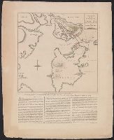
- Published / Created:
- 27 Novr. 1775.
- Call Number:
- 764 B65 1775G
- Container / Volume:
- BRBL_00454
- Image Count:
- 1
- Resource Type:
- Maps, Atlases & Globes
- Found in:
- Beinecke Rare Book and Manuscript Library > A plan of the battle on Bunkers Hill : fought on the 17th of June 1775, by an officer on the spot.
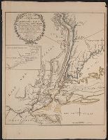
- Published / Created:
- 1776
- Call Number:
- 771hc 1776B
- Container / Volume:
- BRBL_00495
- Image Count:
- 1
- Resource Type:
- Maps, Atlases & Globes
- Found in:
- Beinecke Rare Book and Manuscript Library > The Seat of Action between the British and American Forces ... the Western part of Long Island ... Staten Island ... Amboy and New York ... Hudson's river from Courtland to Sandy Hook .... Surveys of Major Holland.
- Creator:
- Pownall, Thomas, 1722-1805
- Published / Created:
- 1776
- Call Number:
- Franklin 131 1776-5
- Image Count:
- 1
- Resource Type:
- Maps, Atlases & Globes
- Found in:
- Beinecke Rare Book and Manuscript Library > The provinces of New York and New Jersey [cartographic material] : with part of Pensilvania, and the Province of Quebec / drawn by Major Holland, Surveyor General, of the Northern District in America ; corrected and improved, from the original materials, by Governr. Pownall, Member of Parliament, 1776.