Search
You Searched For
Search Results
- Creator:
- Vancouver, George, 1757-1798
- Published / Created:
- [1798]
- Call Number:
- BrSides Folio 2017 57
- Collection Title:
- Voyage of discovery to the North Pacific ocean, and round the world.
- Image Count:
- 1
- Resource Type:
- Maps, Atlases & Globes
- Found in:
- Beinecke Rare Book and Manuscript Library > Views of parts of the coast of North West America / W. Alexander, delt. from sketches made on the spot ; J. Fittler sculp.
- Creator:
- Vancouver, George, 1757-1798
- Published / Created:
- [1798]
- Call Number:
- BrSides Folio 2017 58
- Collection Title:
- Voyage of discovery to the North Pacific ocean, and round the world.
- Image Count:
- 1
- Resource Type:
- Maps, Atlases & Globes
- Found in:
- Beinecke Rare Book and Manuscript Library > Views of parts of the coast of North West America / W. Alexander, delt. from sketches made on the spot ; engraved by B.T. Pouncy.
- Creator:
- Vancouver, George, 1757-1798
- Published / Created:
- [1798]
- Call Number:
- BrSides Folio 2017 59
- Collection Title:
- Voyage of discovery to the North Pacific ocean, and round the world.
- Image Count:
- 1
- Resource Type:
- Maps, Atlases & Globes
- Found in:
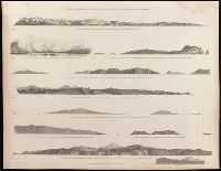
- Beinecke Rare Book and Manuscript Library > Views of the headlands and islands on the coasts of North West and South America / W. Alexander, delt. from sketches made on the spot ; J. Fittler, sculp.
- Creator:
- Wallis, J. (John), -1818
- Published / Created:
- Augt. 2nd, 1798.
- Call Number:
- 32 1798
- Container / Volume:
- BRBL_00044
- Image Count:
- 1
- Resource Type:
- Maps, Atlases & Globes
- Found in:
- Beinecke Rare Book and Manuscript Library > Wallis's new and correct map of the post roads of England and Wales.
- Published / Created:
- [1840?]
- Call Number:
- 654 1840
- Container / Volume:
- BRBL_00344
- Image Count:
- 2
- Resource Type:
- Maps, Atlases & Globes
- Found in:
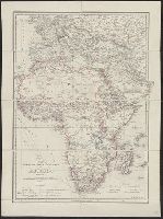
- Beinecke Rare Book and Manuscript Library > West Africa. Engraved by J. & C. Walker.
- Creator:
- Arrowsmith, John, 1790-1873
- Published / Created:
- 1858
- Call Number:
- 36 1858A
- Container / Volume:
- BRBL_00120
- Image Count:
- 1
- Resource Type:
- Maps, Atlases & Globes
- Found in:
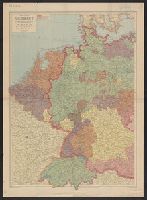
- Beinecke Rare Book and Manuscript Library > Western Germany / by J. Arrowsmith.
- Published / Created:
- 1832
- Call Number:
- 36 1832
- Container / Volume:
- BRBL_00119
- Image Count:
- 1
- Resource Type:
- Maps, Atlases & Globes
- Found in:
- Beinecke Rare Book and Manuscript Library > Western Germany By J. Arrowsmith.
- Creator:
- George Philip & Son
London Geographical Institute
- Published / Created:
- 1940
- Call Number:
- 36 1940A
- Container / Volume:
- BRBL_00121
- Image Count:
- 1
- Resource Type:
- Maps, Atlases & Globes
- Found in:
- Beinecke Rare Book and Manuscript Library > Western Germany, with Holland, Belgium and Switzerland.
- Creator:
- Great Britain. Hydrographic Dept
J. & C. Walker (Firm)
- Published / Created:
- [1866?]
- Call Number:
- 23cea J328 1861
- Image Count:
- 1
- Resource Type:
- Maps, Atlases & Globes
- Found in:
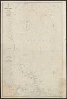
- Beinecke Rare Book and Manuscript Library > Western part of the Java Sea : from Lucipara I. to Sunda Strait and Batavia, corrected to 1861 / engraved by J. & C. Walker.
- Published / Created:
- [1916?]
- Call Number:
- BrSides Elephant Folio 2019 3
- Image Count:
- 1
- Resource Type:
- Maps, Atlases & Globes
- Found in:
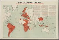
- Beinecke Rare Book and Manuscript Library > What Germany wants : her claims as set forth by leaders of German thought.
- Published / Created:
- [1916?]
- Call Number:
- 11hc 1914R
- Container / Volume:
- BRBL_00010B
- Image Count:
- 1
- Resource Type:
- Maps, Atlases & Globes
- Found in:
- Beinecke Rare Book and Manuscript Library > What Germany wants : her claims as set forth by leaders of German thought.
- Published / Created:
- 1816
- Call Number:
- 32 L84 1816A
- Container / Volume:
- BRBL_00049
- Image Count:
- 1
- Resource Type:
- Maps, Atlases & Globes
- Found in:
- Beinecke Rare Book and Manuscript Library > William Belch's New Map of London.
- Published / Created:
- 1755
- Call Number:
- 3223 1755
- Container / Volume:
- BRBL_00060
- Image Count:
- 1
- Resource Type:
- Maps, Atlases & Globes
- Found in:
- Beinecke Rare Book and Manuscript Library > Wiltshire ... Eman: Bowen ...
- Published / Created:
- c1914.
- Call Number:
- 32am L84 1914
- Container / Volume:
- BRBL_00075
- Image Count:
- 1
- Resource Type:
- Maps, Atlases & Globes
- Found in:
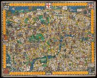
- Beinecke Rare Book and Manuscript Library > Wonderground map of the London Town drawn by MacDonald Gill.
- Published / Created:
- c1914.
- Call Number:
- 32am L84 1914
- Container / Volume:
- BRBL_00075
- Image Count:
- 1
- Resource Type:
- Maps, Atlases & Globes
- Found in:
- Beinecke Rare Book and Manuscript Library > Wonderground map of the London Town drawn by MacDonald Gill.
- Published / Created:
- [1855?]
- Call Number:
- 3191gm 1855
- Container / Volume:
- BRBL_00041
- Image Count:
- 1
- Resource Type:
- Maps, Atlases & Globes
- Found in:
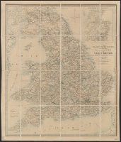
- Beinecke Rare Book and Manuscript Library > Wyld's A map of England, Wales, & Scotland describing all the direct and principal cross roads of Great Britain, with the distances measured between the market towns and from London: Likewise the Great Rivers and Navigable Canals and Railroads.
- Creator:
- Wyld, James, 1812-1887
- Published / Created:
- 1873
- Call Number:
- 6555 1873
- Container / Volume:
- BRBL_00346
- Image Count:
- 1
- Resource Type:
- Maps, Atlases & Globes
- Found in:
- Beinecke Rare Book and Manuscript Library > Wyld's Map of Ashanti : and neighbouring states with the British Possessions on the Gold Coast / published by James Wyld, Geographer to the Queen, 457 Strand, 11 & 12 Charing Cross & 2 Royal Exchange, London, November 20, 1873.
- Creator:
- Wyld, James, 1812-1887
- Published / Created:
- [1875?]
- Call Number:
- 60 1875
- Container / Volume:
- BRBL_00327
- Image Count:
- 1
- Resource Type:
- Maps, Atlases & Globes
- Found in:
- Beinecke Rare Book and Manuscript Library > Wyld's map shewing the various explorations in Africa / James Wyld.
- Creator:
- Wyld, James, 1812-1887
- Published / Created:
- 1861
- Call Number:
- 754hc 1861E
- Container / Volume:
- BRBL_00420
- Image Count:
- 1
- Resource Type:
- Maps, Atlases & Globes
- Found in:
- Beinecke Rare Book and Manuscript Library > Wyld's military map of the United States, the northern states, and the southern confederate states: with the forts, harbours, arsenals, and military positions.
- Creator:
- Wyld, James, 1812-1887
- Published / Created:
- [1862]
- Call Number:
- 32 L84 1862
- Container / Volume:
- BRBL_00050
- Image Count:
- 1
- Resource Type:
- Maps, Atlases & Globes
- Found in:
- Beinecke Rare Book and Manuscript Library > Wyld's new plan of London = Nouveau plan des Londres = Neuer Plan von London.
- Published / Created:
- 1858
- Call Number:
- 32 L84 1858A
- Container / Volume:
- BRBL_00050
- Image Count:
- 1
- Resource Type:
- Maps, Atlases & Globes
- Found in:
- Beinecke Rare Book and Manuscript Library > Wyld's new plan of London for 1858.
- Published / Created:
- [1845?]
- Call Number:
- 530 No. 12
- Container / Volume:
- BRBL_00287
- Image Count:
- 1
- Resource Type:
- Maps, Atlases & Globes
- Found in:
- Beinecke Rare Book and Manuscript Library > [Ancient Near East] Asia Minor Antiqua by William Henry Francis Plate L.L.D. ... J. & C. Walker, Sculp.
- Published / Created:
- [19--?]
- Call Number:
- 32 L84 1900
- Container / Volume:
- BRBL_00051
- Image Count:
- 5
- Resource Type:
- Maps, Atlases & Globes
- Found in:
- Beinecke Rare Book and Manuscript Library > [Map of London and Environs].
- Call Number:
- 11ba 1915
- Container / Volume:
- BRBL_00010A
- Image Count:
- 1
- Resource Type:
- Maps, Atlases & Globes
- Found in:
- Beinecke Rare Book and Manuscript Library > [Philips' 12 inch terrestrial globe.]
- Published / Created:
- 1915
- Call Number:
- 11ba 1915A
- Container / Volume:
- BRBL_00010A
- Image Count:
- 1
- Resource Type:
- Maps, Atlases & Globes
- Found in:
- Beinecke Rare Book and Manuscript Library > [Philips' 4 inch graphic globe.]
- Published / Created:
- 1825
- Call Number:
- 23cea 1825A
- Container / Volume:
- BRBL_00021
- Image Count:
- 2
- Resource Type:
- Maps, Atlases & Globes
- Found in:
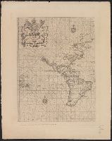
- Beinecke Rare Book and Manuscript Library > [Two charts of the Pacific Ocean, showing the Northwestern America and Sandwich Islands and ports].
- Published / Created:
- March 1880.
- Call Number:
- 11 1584
- Container / Volume:
- BRBL_00722
- Image Count:
- 2
- Resource Type:
- Maps, Atlases & Globes
- Found in:
- Beinecke Rare Book and Manuscript Library > [World map].
- Published / Created:
- March 1880.
- Call Number:
- 11 1600
- Container / Volume:
- BRBL_00002
- Image Count:
- 1
- Resource Type:
- Maps, Atlases & Globes
- Found in:
- Beinecke Rare Book and Manuscript Library > [World map].
- Published / Created:
- March 1880.
- Call Number:
- 11 1600
- Image Count:
- 1
- Resource Type:
- Maps, Atlases & Globes
- Found in:
- Beinecke Rare Book and Manuscript Library > [World map].