Search
You Searched For
Search Results
- Creator:
- United States. Congress. House. Committee on the Public Lands
- Published / Created:
- [1878?].
- Call Number:
- 75 1878
- Container / Volume:
- BRBL_00406
- Image Count:
- 16
- Resource Type:
- Maps, Atlases & Globes
- Found in:
- Beinecke Rare Book and Manuscript Library > 1876 Centennial map of the United States and territories : showing the extent of public surveys, indian and military reservations, land grant R.R. rail roads, canals, cities, towns & other details / compiled from the official surveys of the General Land O
- Creator:
- Magnus, Charles
- Published / Created:
- [1852]
- Call Number:
- 771 N49 1852
- Container / Volume:
- BRBL_00485
- Image Count:
- 1
- Resource Type:
- Maps, Atlases & Globes
- Found in:
- Beinecke Rare Book and Manuscript Library > Complete map of the cities of New York, Brooklyn and Williamsburgh [cartographic material].
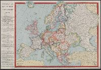
- Creator:
- C.S. Hammond & Company
- Published / Created:
- [ca. 1920]
- Call Number:
- 30fd 1920
- Container / Volume:
- BRBL_00037B
- Image Count:
- 1
- Resource Type:
- Maps, Atlases & Globes
- Found in:
- Beinecke Rare Book and Manuscript Library > Europe.
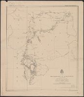
- Creator:
- Ludlow, William, 1843-1901
- Published / Created:
- [1874?]
- Call Number:
- 821 1874
- Container / Volume:
- BRBL_00566
- Image Count:
- 1
- Resource Type:
- Maps, Atlases & Globes
- Found in:
- Beinecke Rare Book and Manuscript Library > Map of a reconnaissance of the Black Hills, July and August, 1874, with troops under command of Lt. Col. G.A. Custer, 7th Cavalry / by Capt. Wm. Ludlow, Corps of Engineers.
- Creator:
- Van Loan, Walton
- Published / Created:
- 1877
- Call Number:
- 771 C29 1877
- Container / Volume:
- BRBL_00481
- Image Count:
- 1
- Resource Type:
- Maps, Atlases & Globes
- Found in:
- Beinecke Rare Book and Manuscript Library > Map of all points of interest within four miles of the Catskill Mountain House with roads and foot paths / surveyed and drawn by Walton Van Loan.
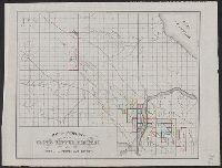
- Creator:
- J.O. Seymour & Co
- Published / Created:
- [ca. 1870]
- Call Number:
- 811gfc P831 1870
- Container / Volume:
- BRBL_00554
- Image Count:
- 1
- Resource Type:
- Maps, Atlases & Globes
- Found in:
- Beinecke Rare Book and Manuscript Library > Map of property of the Globe Copper Company and mines in the Portage Lake District.
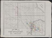
- Creator:
- Welton, E. W
- Published / Created:
- [1866?]
- Call Number:
- 837gfc R25 1866
- Container / Volume:
- BRBL_00595
- Image Count:
- 1
- Resource Type:
- Maps, Atlases & Globes
- Found in:
- Beinecke Rare Book and Manuscript Library > Map of the Reese River mining districts : showing explorations of D.E. Buel in 1864, and Joseph Todd in 1865 / compiled by John Todd ; drawn by E.W. Welton.
- Creator:
- Croskey, Joseph Rodney
- Published / Created:
- 1842
- Call Number:
- 796ad 1842
- Container / Volume:
- BRBL_00529
- Image Count:
- 1
- Resource Type:
- Maps, Atlases & Globes
- Found in:
- Beinecke Rare Book and Manuscript Library > Map of the Republic of Texas, exhibiting the property of John Woodward / drawn by Joseph Rodney Croskey.
- Creator:
- United States. General Land Office
- Published / Created:
- 1876
- Call Number:
- 75 1876
- Container / Volume:
- BRBL_00405
- Image Count:
- 6
- Resource Type:
- Maps, Atlases & Globes
- Found in:
- Beinecke Rare Book and Manuscript Library > Map of the United States and territories, showing the extent of public surveys, Indian and military reservations, land grant R.R., rail roads, canals, and other details / compiled from the official surveys of the General Land Office, and other authentic s