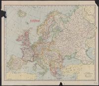
Hammond's large scale war map Italian Front, War map Italian Front, and War map of the Western Front
Description:
Both maps show battle lines as of Sept. 23rd, 1918., Copy 1: Printed on linen., Maps show railways, canals, forests, aircraft depots, wireless stations, forts, fortified towns, and nava, and Possibly issued with an index, which is no longer present.
Publisher:
C.S. Hammond & Co. (Incorporated) Engravers, Printers, Publishers 30 Church Street (Hudson Terminal),
Subject (Geographic):
Europe, Western--Maps and Italy--Maps
Subject (Topic):
World War, 1914-1918--Campaigns--Italy--Maps and World War, 1914-1918--Campaigns--Western Front--Maps
Hammond's large scale war map Italian Front, War map Italian Front, and War map of the Western Front
Description:
Both maps show battle lines as of Sept. 23rd, 1918., Maps show railways, canals, forests, aircraft depots, wireless stations, forts, fortified towns, and naval arsenals, etc., and Possibly issued with an index, which is no longer present.
Publisher:
C.S. Hammond & Co. (Incorporated) Engravers, Printers, Publishers 30 Church Street (Hudson Terminal),
Subject (Geographic):
Europe, Western--Maps and Italy--Maps
Subject (Topic):
World War, 1914-1918--Campaigns--Italy--Maps and World War, 1914-1918--Campaigns--Western Front--Maps
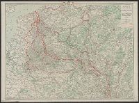
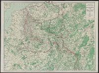
Relief shown by spot heights. and Shows "Furthest advance of the German Army," "Battle line August 15th, 1917," railways, canals, forests and woods, aircraft depots, wireless stations, forts and redoubts and fortresses, fortified towns and naval arsenals.
Publisher:
C.S. Hammond,
Subject (Geographic):
Europe, Western--Maps
Subject (Topic):
World War, 1914-1918--Campaigns--Western Front--Maps
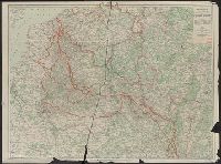
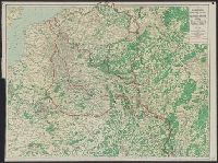
Indicates "Furthest advance of the German Army", and "Battle line May 10th, 1918" overprinted in red., Relief shown by spot heights., and Shows railways, canals, aircraft depots, wireless stations, forts, naval arsenals and boundaries.
Publisher:
C.S. Hammond,
Subject (Geographic):
Europe--Maps
Subject (Topic):
World War, 1914-1918--Campaigns--Europe--Maps and World War, 1914-1918--Campaigns--Western Front--Maps
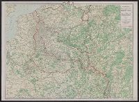
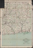
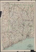
Includes the eastern part of Connecticut from Hartford east to the Rhode Island border. and Indicates best and fair roads, interurban electric railways, and railroads.
Publisher:
C.S. Hammond & Co.,
Subject (Geographic):
Connecticut--Maps
Subject (Name):
Geological Survey (U.S.) and U.S. Coast and Geodetic Survey
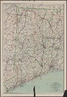
Includes the western part of Connecticut from The New York border to West Hartford and New Britain. and Indicates main auto routes and state improved roads, interurban electric lines, and railroads.
Publisher:
C.S. Hammond & Co.,
Subject (Geographic):
Connecticut--Maps
Subject (Name):
Geological Survey (U.S.) and U.S. Coast and Geodetic Survey